Bath Topo Map Michigan
To zoom in, hover over the map of Bath
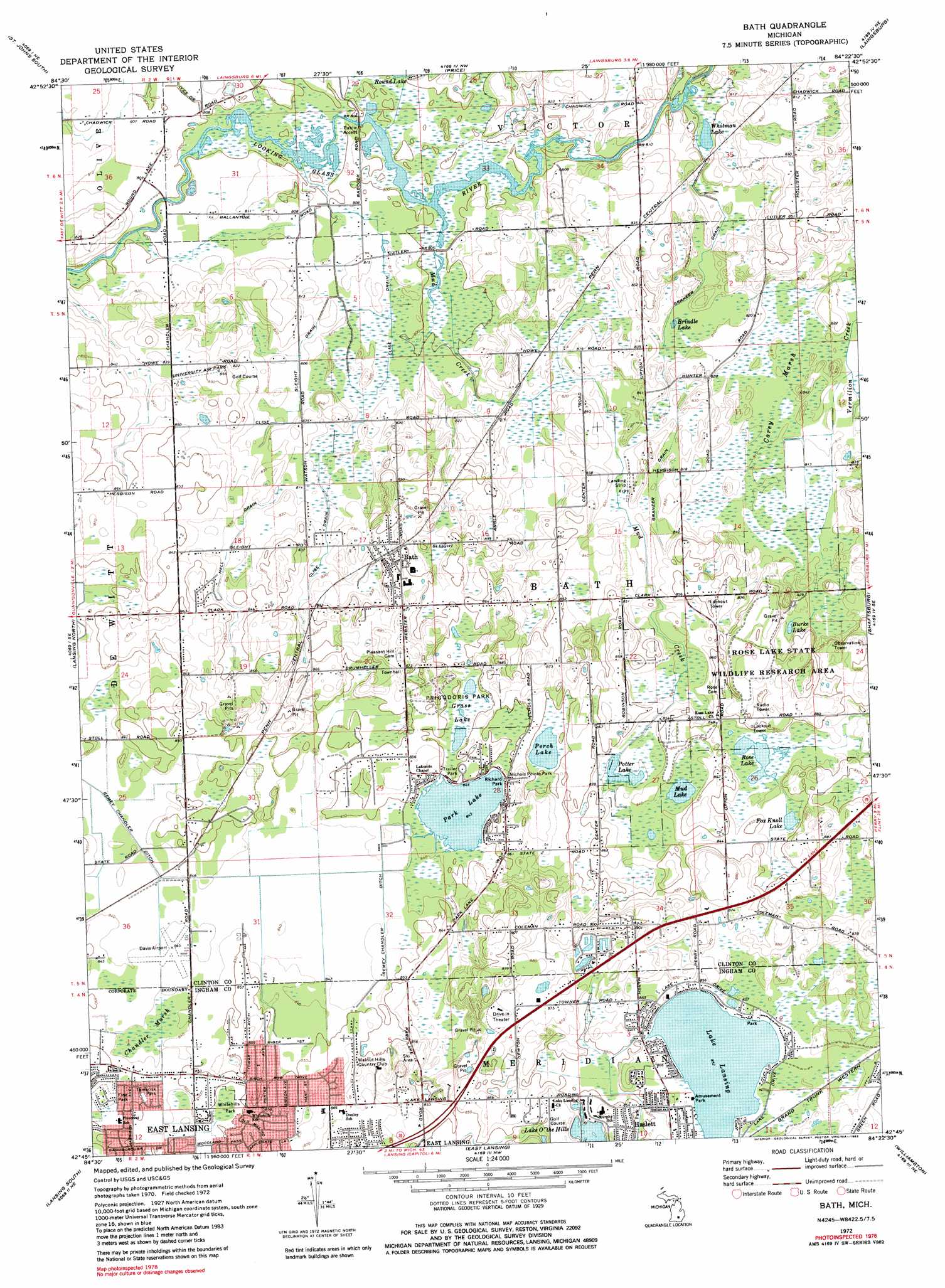
USGS Topo Quad 42084g4 - 1:24,000 scale
| Topo Map Name: | Bath |
| USGS Topo Quad ID: | 42084g4 |
| Print Size: | ca. 21 1/4" wide x 27" high |
| Southeast Coordinates: | 42.75° N latitude / 84.375° W longitude |
| Map Center Coordinates: | 42.8125° N latitude / 84.4375° W longitude |
| U.S. State: | MI |
| Filename: | o42084g4.jpg |
| Download Map JPG Image: | Bath topo map 1:24,000 scale |
| Map Type: | Topographic |
| Topo Series: | 7.5´ |
| Map Scale: | 1:24,000 |
| Source of Map Images: | United States Geological Survey (USGS) |
| Alternate Map Versions: |
Bath MI 1972, updated 1974 Download PDF Buy paper map Bath MI 1972, updated 1982 Download PDF Buy paper map Bath MI 2011 Download PDF Buy paper map Bath MI 2014 Download PDF Buy paper map Bath MI 2017 Download PDF Buy paper map |
1:24,000 Topo Quads surrounding Bath
Maple Rapids |
Saint Johns North |
Ovid West |
Ovid East |
Owosso North |
Riley |
Saint Johns South |
Price |
Laingsburg |
Owosso South |
Wacousta |
Lansing North |
Bath |
Shaftsburg |
Perry |
Dimondale |
Lansing South |
East Lansing |
Williamston |
Webberville |
Eaton Rapids |
Aurelius |
Mason |
Dansville |
Millville |
> Back to 42084e1 at 1:100,000 scale
> Back to 42084a1 at 1:250,000 scale
> Back to U.S. Topo Maps home
Bath topo map: Gazetteer
Bath: Airports
Davis Airport elevation 256m 839′University Airpark elevation 258m 846′
Wisner Airport elevation 249m 816′
Bath: Canals
Clise Drain elevation 246m 807′Graneer Drain elevation 249m 816′
Graneer Drain elevation 244m 800′
Hall Drain elevation 250m 820′
Sleight Drain elevation 246m 807′
Bath: Lakes
Brindle Lake elevation 246m 807′Burke Lake elevation 252m 826′
Fox Knoll Lake elevation 256m 839′
Lake Lansing elevation 260m 853′
Lake O'The Hills elevation 259m 849′
Mud Lake elevation 255m 836′
Park Lake elevation 257m 843′
Perch Lake elevation 258m 846′
Potter Lake elevation 252m 826′
Priggooris Lake elevation 259m 849′
Rose Lake elevation 255m 836′
Whitman Lake elevation 243m 797′
Bath: Parks
Bath School Disaster Historical Marker elevation 266m 872′Fine Park elevation 257m 843′
Nichols Pointe Park elevation 258m 846′
Priggooris Park elevation 259m 849′
Richard Park elevation 259m 849′
Rose Lake State Wildlife Research Area elevation 266m 872′
Tamarisk Park elevation 258m 846′
Whitehills Park elevation 260m 853′
Bath: Populated Places
Bath elevation 262m 859′Dutch Mills Mobile Home Park elevation -1m -4′
Oak Island Mobile Home Park elevation 264m 866′
Park Lake Mobile Home Court elevation 259m 849′
Bath: Post Offices
Bath Post Office elevation 265m 869′Bath: Streams
Ives Drain elevation 243m 797′Mud Creek elevation 244m 800′
Remey Chandler Drain elevation 254m 833′
Bath: Swamps
Chandler Marsh elevation 256m 839′Corey Marsh elevation 246m 807′
Bath digital topo map on disk
Buy this Bath topo map showing relief, roads, GPS coordinates and other geographical features, as a high-resolution digital map file on DVD:
Northern Illinois, Northern Indiana & Southwestern Michigan
Buy digital topo maps: Northern Illinois, Northern Indiana & Southwestern Michigan