Saint Johns South Topo Map Michigan
To zoom in, hover over the map of Saint Johns South
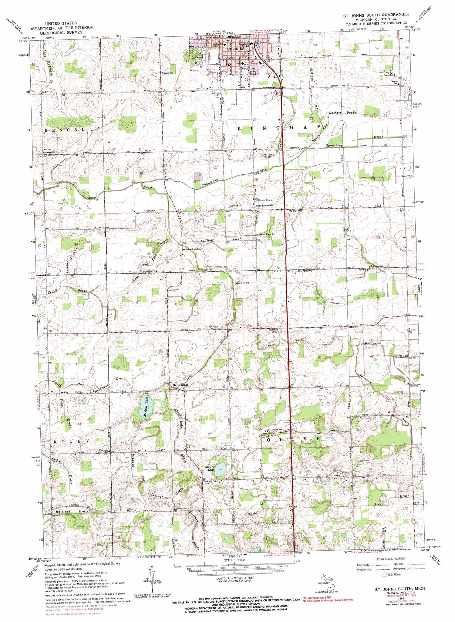
USGS Topo Quad 42084h5 - 1:24,000 scale
| Topo Map Name: | Saint Johns South |
| USGS Topo Quad ID: | 42084h5 |
| Print Size: | ca. 21 1/4" wide x 27" high |
| Southeast Coordinates: | 42.875° N latitude / 84.5° W longitude |
| Map Center Coordinates: | 42.9375° N latitude / 84.5625° W longitude |
| U.S. State: | MI |
| Filename: | o42084h5.jpg |
| Download Map JPG Image: | Saint Johns South topo map 1:24,000 scale |
| Map Type: | Topographic |
| Topo Series: | 7.5´ |
| Map Scale: | 1:24,000 |
| Source of Map Images: | United States Geological Survey (USGS) |
| Alternate Map Versions: |
St. Johns South MI 1965, updated 1967 Download PDF Buy paper map St. Johns South MI 1965, updated 1974 Download PDF Buy paper map St. Johns South MI 1965, updated 1991 Download PDF Buy paper map Saint Johns South MI 2011 Download PDF Buy paper map Saint Johns South MI 2014 Download PDF Buy paper map Saint Johns South MI 2017 Download PDF Buy paper map |
1:24,000 Topo Quads surrounding Saint Johns South
Carson City |
Perrinton |
Pompeii |
Ashley |
Chapin |
Hubbardston |
Maple Rapids |
Saint Johns North |
Ovid West |
Ovid East |
Wasphalia |
Riley |
Saint Johns South |
Price |
Laingsburg |
Eagle |
Wacousta |
Lansing North |
Bath |
Shaftsburg |
Needmore |
Dimondale |
Lansing South |
East Lansing |
Williamston |
> Back to 42084e1 at 1:100,000 scale
> Back to 42084a1 at 1:250,000 scale
> Back to U.S. Topo Maps home
Saint Johns South topo map: Gazetteer
Saint Johns South: Canals
Alward Lake Drain elevation 235m 770′Baldwin and Muskrat Drain elevation 233m 764′
Baugh Gachter Drain elevation 225m 738′
Blizzard Drain elevation 242m 793′
Bond and Palmer Drain elevation 225m 738′
Clavey Drain elevation 239m 784′
Coffman Drain elevation 237m 777′
Gillison Drain elevation 227m 744′
Lancaster Drain elevation 223m 731′
Locher Drain elevation 239m 784′
Pectil Drain elevation 229m 751′
Sheldon Drain elevation 227m 744′
Smith and Merchant Drain elevation 232m 761′
Yanz Drain elevation 234m 767′
Saint Johns South: Lakes
Alward Lake elevation 237m 777′Muskrat Lake elevation 231m 757′
Saint Johns South: Populated Places
Meadows of Saint Johns Mobile Home Park elevation 224m 734′Saint Johns South: Post Offices
Corkin Post Office (historical) elevation 244m 800′Merlebeach Post Office (historical) elevation 237m 777′
Olive Post Office (historical) elevation 237m 777′
Saint Johns South: Streams
Hamilton Drain elevation 235m 770′Holden Drain elevation 225m 738′
Spaulding Drain elevation 219m 718′
Saint Johns South digital topo map on disk
Buy this Saint Johns South topo map showing relief, roads, GPS coordinates and other geographical features, as a high-resolution digital map file on DVD:
Northern Illinois, Northern Indiana & Southwestern Michigan
Buy digital topo maps: Northern Illinois, Northern Indiana & Southwestern Michigan