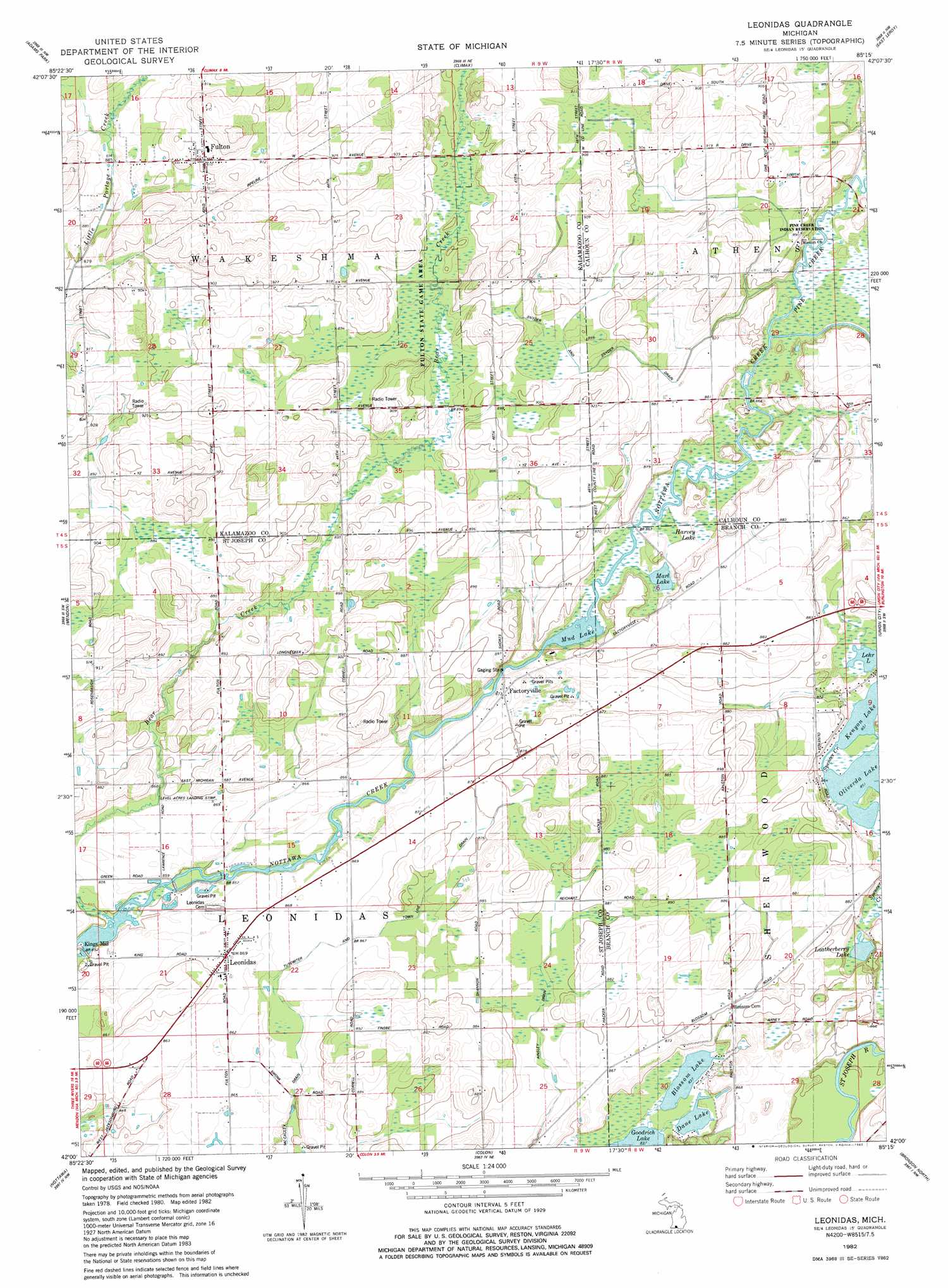
Leonidas Topo Map Michigan
To zoom in, hover over the map of Leonidas
USGS Topo Quad 42085a3 - 1:24,000 scale
| Topo Map Name: | Leonidas |
| USGS Topo Quad ID: | 42085a3 |
| Print Size: | ca. 21 1/4" wide x 27" high |
| Southeast Coordinates: | 42° N latitude / 85.25° W longitude |
| Map Center Coordinates: | 42.0625° N latitude / 85.3125° W longitude |
| U.S. State: | MI |
| Filename: | o42085a3.jpg |
| Download Map JPG Image: | Leonidas topo map 1:24,000 scale |
| Map Type: | Topographic |
| Topo Series: | 7.5´ |
| Map Scale: | 1:24,000 |
| Source of Map Images: | United States Geological Survey (USGS) |
| Alternate Map Versions: |
Leonidas MI 1982, updated 1982 Download PDF Buy paper map Leonidas MI 2011 Download PDF Buy paper map Leonidas MI 2014 Download PDF Buy paper map Leonidas MI 2016 Download PDF Buy paper map |
1:24,000 Topo Quads surrounding Leonidas
Kalamazoo |
Galesburg |
Augusta |
Battle Creek |
Ceresco |
Portage |
Adams Park |
Climax |
East Leroy |
Ellis Corners |
Vicksburg |
Mendon |
Leonidas |
Union City |
Burlington |
Three Rivers East |
Nottawa |
Colon |
Bronson North |
Coldwater West |
Klinger Lake |
Sturgis |
Burr Oak |
Bronson South |
Kinderhook |
> Back to 42085a1 at 1:100,000 scale
> Back to 42084a1 at 1:250,000 scale
> Back to U.S. Topo Maps home
Leonidas topo map: Gazetteer
Leonidas: Airports
Level Acres Landing Strip elevation 265m 869′Leonidas: Canals
Ashley Drain elevation 262m 859′McCauley Drain elevation 259m 849′
Snyder and Snyder Drain elevation 270m 885′
Tutewiter and Town Line Drain elevation 264m 866′
Leonidas: Lakes
Blossom Lake elevation 255m 836′Dane Lake elevation 255m 836′
Harvey Lake elevation 262m 859′
Kenyon Lake elevation 259m 849′
Leatherberry Lake elevation 260m 853′
Lehr Lake elevation 260m 853′
Marl Lake elevation 261m 856′
Mud Lake elevation 260m 853′
Oliverda Lake elevation 259m 849′
Leonidas: Parks
Fulton State Game Area elevation 271m 889′Leonidas: Populated Places
Factoryville elevation 265m 869′Factoryville elevation 265m 869′
Fulton elevation 279m 915′
Leonidas elevation 264m 866′
Leonidas: Post Offices
Leonidas Post Office elevation 264m 866′Sherwood Post Office (historical) elevation 270m 885′
Slayton Post Office (historical) elevation 273m 895′
Leonidas: Streams
Pine Creek elevation 263m 862′Leonidas digital topo map on disk
Buy this Leonidas topo map showing relief, roads, GPS coordinates and other geographical features, as a high-resolution digital map file on DVD:
Northern Illinois, Northern Indiana & Southwestern Michigan
Buy digital topo maps: Northern Illinois, Northern Indiana & Southwestern Michigan