Schoolcraft Nw Topo Map Michigan
To zoom in, hover over the map of Schoolcraft Nw
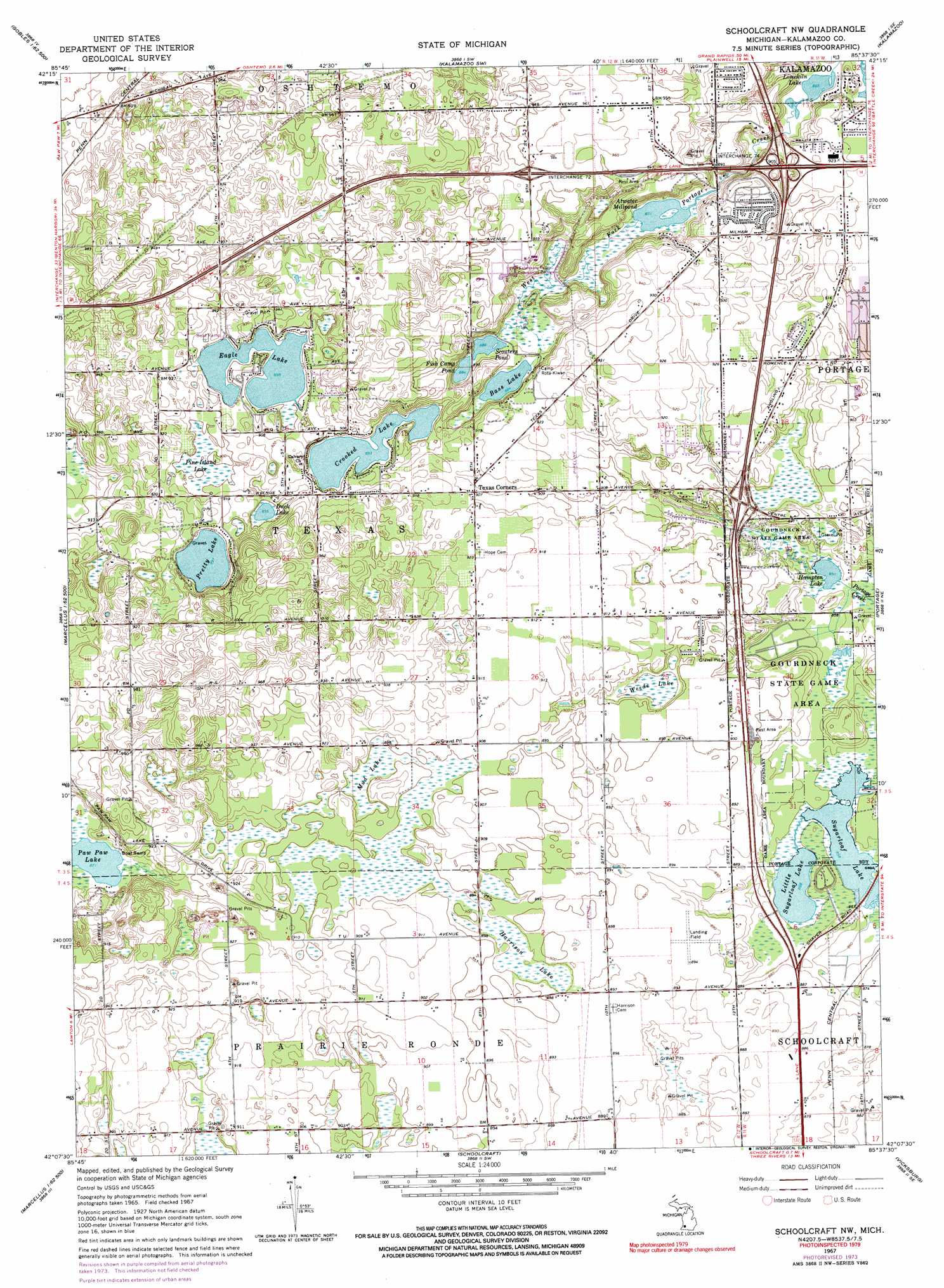
USGS Topo Quad 42085b6 - 1:24,000 scale
| Topo Map Name: | Schoolcraft Nw |
| USGS Topo Quad ID: | 42085b6 |
| Print Size: | ca. 21 1/4" wide x 27" high |
| Southeast Coordinates: | 42.125° N latitude / 85.625° W longitude |
| Map Center Coordinates: | 42.1875° N latitude / 85.6875° W longitude |
| U.S. State: | MI |
| Filename: | o42085b6.jpg |
| Download Map JPG Image: | Schoolcraft Nw topo map 1:24,000 scale |
| Map Type: | Topographic |
| Topo Series: | 7.5´ |
| Map Scale: | 1:24,000 |
| Source of Map Images: | United States Geological Survey (USGS) |
| Alternate Map Versions: |
Schoolcraft NW MI 1967, updated 1969 Download PDF Buy paper map Schoolcraft NW MI 1967, updated 1974 Download PDF Buy paper map Schoolcraft NW MI 1967, updated 1990 Download PDF Buy paper map Schoolcraft NW MI 2011 Download PDF Buy paper map Schoolcraft NW MI 2014 Download PDF Buy paper map Schoolcraft NW MI 2016 Download PDF Buy paper map |
1:24,000 Topo Quads surrounding Schoolcraft Nw
Bloomingdale |
Merson |
Otsego |
Kalamazoo Ne |
Delton |
Gobles West |
Gobles East |
Kalamazoo Sw |
Kalamazoo |
Galesburg |
Paw Paw |
Lawton |
Schoolcraft Nw |
Portage |
Adams Park |
Decatur |
Marcellus |
Schoolcraft |
Vicksburg |
Mendon |
Vandalia |
Jones |
Three Rivers West |
Three Rivers East |
Nottawa |
> Back to 42085a1 at 1:100,000 scale
> Back to 42084a1 at 1:250,000 scale
> Back to U.S. Topo Maps home
Schoolcraft Nw topo map: Gazetteer
Schoolcraft Nw: Airports
Perry Airport elevation 271m 889′Whitcomb Field elevation 277m 908′
Schoolcraft Nw: Crossings
Interchange 31 elevation 273m 895′Interchange 34 elevation 275m 902′
Interchange 72 elevation 293m 961′
Interchange 74 elevation 275m 902′
Schoolcraft Nw: Lakes
Atwater Millpond elevation 265m 869′Bass Lake elevation 269m 882′
Crooked Lake elevation 272m 892′
Duck Lake elevation 274m 898′
Eagle Lake elevation 274m 898′
Fish Camp Pond elevation 269m 882′
Hampton Lake elevation 259m 849′
Limekiln Lake elevation 263m 862′
Little Sugarloaf Lake elevation 261m 856′
Paw Paw Lake elevation 265m 869′
Pretty Lake elevation 273m 895′
Scouters Pond elevation 269m 882′
Sugarloaf Lake elevation 261m 856′
Schoolcraft Nw: Parks
Gourdneck State Game Area elevation 267m 875′Kalamazoo Region Historical Marker elevation 288m 944′
Schoolcraft Nw: Populated Places
Texas Corners elevation 277m 908′Schoolcraft Nw: Post Offices
Texas Post Office (historical) elevation 277m 908′Schoolcraft Nw: Swamps
Harrison Lake elevation 271m 889′Mud Lake elevation 274m 898′
Pine Island elevation 274m 898′
Weeds Lake elevation 268m 879′
Schoolcraft Nw digital topo map on disk
Buy this Schoolcraft Nw topo map showing relief, roads, GPS coordinates and other geographical features, as a high-resolution digital map file on DVD:
Northern Illinois, Northern Indiana & Southwestern Michigan
Buy digital topo maps: Northern Illinois, Northern Indiana & Southwestern Michigan