Kalamazoo Topo Map Michigan
To zoom in, hover over the map of Kalamazoo
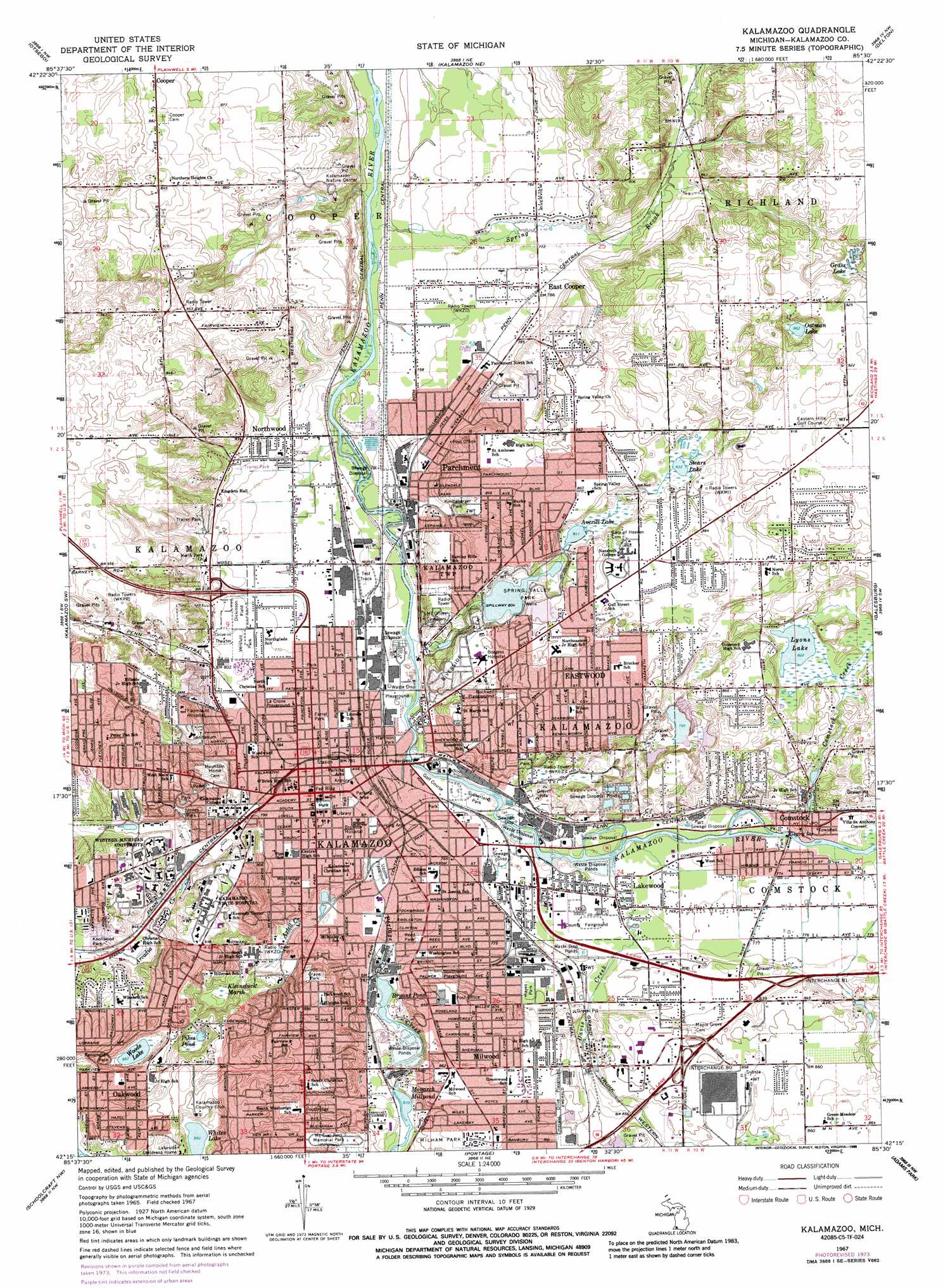
USGS Topo Quad 42085c5 - 1:24,000 scale
| Topo Map Name: | Kalamazoo |
| USGS Topo Quad ID: | 42085c5 |
| Print Size: | ca. 21 1/4" wide x 27" high |
| Southeast Coordinates: | 42.25° N latitude / 85.5° W longitude |
| Map Center Coordinates: | 42.3125° N latitude / 85.5625° W longitude |
| U.S. State: | MI |
| Filename: | o42085c5.jpg |
| Download Map JPG Image: | Kalamazoo topo map 1:24,000 scale |
| Map Type: | Topographic |
| Topo Series: | 7.5´ |
| Map Scale: | 1:24,000 |
| Source of Map Images: | United States Geological Survey (USGS) |
| Alternate Map Versions: |
Kalamazoo MI 1967, updated 1969 Download PDF Buy paper map Kalamazoo MI 1967, updated 1974 Download PDF Buy paper map Kalamazoo MI 1967, updated 1986 Download PDF Buy paper map Kalamazoo MI 1967, updated 1988 Download PDF Buy paper map Kalamazoo MI 1967, updated 1988 Download PDF Buy paper map Kalamazoo MI 1995, updated 1999 Download PDF Buy paper map Kalamazoo MI 2011 Download PDF Buy paper map Kalamazoo MI 2014 Download PDF Buy paper map Kalamazoo MI 2016 Download PDF Buy paper map |
1:24,000 Topo Quads surrounding Kalamazoo
Allegan |
Martin |
Orangeville |
Cloverdale |
Dowling |
Merson |
Otsego |
Kalamazoo Ne |
Delton |
Banfield |
Gobles East |
Kalamazoo Sw |
Kalamazoo |
Galesburg |
Augusta |
Lawton |
Schoolcraft Nw |
Portage |
Adams Park |
Climax |
Marcellus |
Schoolcraft |
Vicksburg |
Mendon |
Leonidas |
> Back to 42085a1 at 1:100,000 scale
> Back to 42084a1 at 1:250,000 scale
> Back to U.S. Topo Maps home
Kalamazoo topo map: Gazetteer
Kalamazoo: Airports
Borgess Medical Center Heliport elevation 258m 846′Bronson Methodist Hospital Heliport elevation 238m 780′
Triple H Airport elevation 235m 770′
Kalamazoo: Crossings
Interchange 80 elevation 262m 859′Interchange 81 elevation 247m 810′
Kalamazoo: Lakes
Averill Lake elevation 247m 810′Bryant Pond elevation 238m 780′
Grass Lake elevation 265m 869′
Lyons Lake elevation 250m 820′
Monarch Millpond elevation 247m 810′
Oatman Lake elevation 263m 862′
Pikes Pond elevation 258m 846′
Stears Lake elevation 254m 833′
Whites Lake elevation 259m 849′
Woods Lake elevation 260m 853′
Kalamazoo: Parks
AUV Auditorium Historical Marker elevation 237m 777′Cooper Congregational Church Historical Marker elevation 254m 833′
Crane Park elevation 270m 885′
David S Walbridge Historical Marker elevation 238m 780′
DeLano Homestead Historical Marker elevation 263m 862′
Dickinson Field elevation 236m 774′
East Hall Historical Marker elevation 272m 892′
Edward Israel Arctic Pioneer Historical Marker elevation 265m 869′
Emerald Drive Playground elevation 260m 853′
Epaphroditus Ransom Historical Marker elevation 239m 784′
Farrel Park elevation 236m 774′
First Baptist Church Historical Marker elevation 239m 784′
First United Methodist Church Historical Marker elevation 240m 787′
First Women's Club in Michigan Historical Marker elevation 240m 787′
Harrison Park elevation 232m 761′
Hayes Park elevation 243m 797′
Haymarket Historic District Historical Marker elevation 237m 777′
Henderson Park West Main Hill Historic District Historical Marker elevation 265m 869′
Jones Park elevation 263m 862′
Kalamazoo Celery Historical Marker elevation 233m 764′
Kalamazoo College Historical Marker elevation 241m 790′
Kalamazoo College Historical Marker elevation 260m 853′
Kalamazoo Gazette Historical Marker elevation 239m 784′
Kalamazoo Nature Center elevation 268m 879′
Kalamazoo School Case Historical Marker elevation 240m 787′
Kalamazoo State Hospital Historical Marker elevation 278m 912′
Kensington Park elevation 262m 859′
Kindleberger Park elevation 241m 790′
Knollwood Park elevation 261m 856′
La Crone Playground elevation 237m 777′
Lincoln at Kalamazoo Historical Marker elevation 240m 787′
Michigan State Grange Historical Marker elevation 237m 777′
Peninsula Building Historical Marker elevation 237m 777′
Pioneer Cemetery Historical Marker elevation 239m 784′
Reed Park elevation 238m 780′
Rockwell Playground elevation 255m 836′
South Street Historic District Historical Marker elevation 241m 790′
Southside Playground elevation 247m 810′
Spring Valley Park elevation 247m 810′
Stuart House Historical Marker elevation 243m 797′
Stuart Neighborhood Historical Marker elevation 241m 790′
Stuart Neighborhood Historical Marker elevation 243m 797′
Stuart Neighborhood Historical Marker elevation 240m 787′
Sutherland Park elevation 231m 757′
Upjohn Company Historical Marker elevation 238m 780′
Upjohn Playground elevation 232m 761′
Versluis Park elevation 237m 777′
Western Michigan University Historical Marker elevation 270m 885′
Westnedge Park elevation 239m 784′
William E Upjohn Historical Marker elevation 238m 780′
Women in the Michigan Grange Historical Marker elevation 237m 777′
Kalamazoo: Populated Places
Comstock elevation 237m 777′East Cooper elevation 239m 784′
Eastwood elevation 262m 859′
Kalamazoo elevation 240m 787′
Lakewood elevation 235m 770′
Milwood elevation 262m 859′
Northwood elevation 236m 774′
Oakwood elevation 274m 898′
Parchment elevation 236m 774′
Kalamazoo: Post Offices
Nazareth Post Office elevation 264m 866′Parchment Post Office (historical) elevation 240m 787′
Kalamazoo: Reservoirs
Spring Valley Lake elevation 245m 803′Kalamazoo: Streams
Arcadia Creek elevation 246m 807′Axtell Creek elevation 232m 761′
Comstock Creek elevation 234m 767′
Davis Creek elevation 232m 761′
Portage Creek elevation 231m 757′
Spring Brook elevation 228m 748′
Kalamazoo: Swamps
Kleinstuck Marsh elevation 251m 823′Kalamazoo digital topo map on disk
Buy this Kalamazoo topo map showing relief, roads, GPS coordinates and other geographical features, as a high-resolution digital map file on DVD:
Northern Illinois, Northern Indiana & Southwestern Michigan
Buy digital topo maps: Northern Illinois, Northern Indiana & Southwestern Michigan