Gobles West Topo Map Michigan
To zoom in, hover over the map of Gobles West
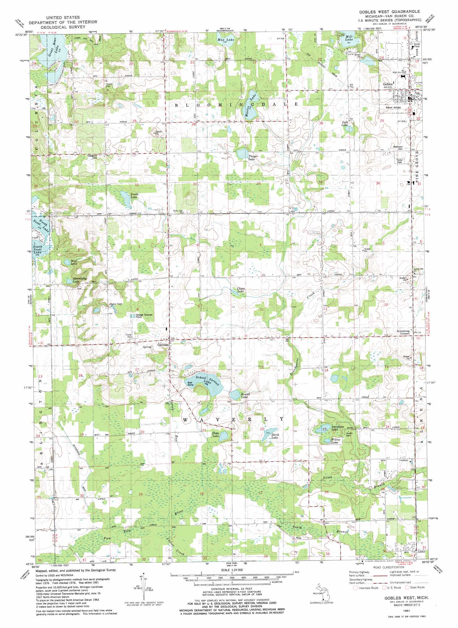
USGS Topo Quad 42085c8 - 1:24,000 scale
| Topo Map Name: | Gobles West |
| USGS Topo Quad ID: | 42085c8 |
| Print Size: | ca. 21 1/4" wide x 27" high |
| Southeast Coordinates: | 42.25° N latitude / 85.875° W longitude |
| Map Center Coordinates: | 42.3125° N latitude / 85.9375° W longitude |
| U.S. State: | MI |
| Filename: | o42085c8.jpg |
| Download Map JPG Image: | Gobles West topo map 1:24,000 scale |
| Map Type: | Topographic |
| Topo Series: | 7.5´ |
| Map Scale: | 1:24,000 |
| Source of Map Images: | United States Geological Survey (USGS) |
| Alternate Map Versions: |
Gobles West MI 1981, updated 1982 Download PDF Buy paper map Gobles West MI 2011 Download PDF Buy paper map Gobles West MI 2014 Download PDF Buy paper map Gobles West MI 2016 Download PDF Buy paper map |
1:24,000 Topo Quads surrounding Gobles West
Glenn |
Fennville |
Millgrove |
Allegan |
Martin |
Lacota |
Pullman |
Bloomingdale |
Merson |
Otsego |
Mcdonald |
Bangor |
Gobles West |
Gobles East |
Kalamazoo Sw |
Hartford |
Lawrence |
Paw Paw |
Lawton |
Schoolcraft Nw |
Sister Lakes |
Twin Lakes |
Decatur |
Marcellus |
Schoolcraft |
> Back to 42085a1 at 1:100,000 scale
> Back to 42084a1 at 1:250,000 scale
> Back to U.S. Topo Maps home
Gobles West topo map: Gazetteer
Gobles West: Airports
Beckman Airport elevation 219m 718′Wesler Airfield elevation 246m 807′
Gobles West: Canals
Butterfield Drain elevation 209m 685′Rich-Dillon Drain elevation 210m 688′
Gobles West: Lakes
Abernathy Lake elevation 209m 685′Chase Lake elevation 218m 715′
Davis Lake elevation 217m 711′
Great Bear Lake elevation 206m 675′
Lyle Lake elevation 233m 764′
Martin Lake elevation 227m 744′
Max Lake elevation 209m 685′
Max Lake elevation 221m 725′
Round Lake elevation 209m 685′
School Section Lake elevation 210m 688′
Shaw Lake elevation 208m 682′
Simmons Lake elevation 211m 692′
Smith Lake elevation 232m 761′
Thayer Lake elevation 226m 741′
Wilcox Lake elevation 212m 695′
Gobles West: Populated Places
Country Holiday Estates Mobile Home Park elevation 235m 770′Glendale elevation 233m 764′
Gobles elevation 249m 816′
Gobles West: Post Offices
Glendale Post Office (historical) elevation 233m 764′Gobles Post Office elevation 247m 810′
Waverly Post Office (historical) elevation 237m 777′
Gobles West: Streams
Brandywine Creek elevation 214m 702′Carter Creek elevation 208m 682′
Haven and Max Lake Drain elevation 206m 675′
North Branch Paw Paw River elevation 209m 685′
North Extension Drain elevation 218m 715′
South Branch Paw Paw River elevation 209m 685′
Spring Run elevation 208m 682′
Gobles West digital topo map on disk
Buy this Gobles West topo map showing relief, roads, GPS coordinates and other geographical features, as a high-resolution digital map file on DVD:
Northern Illinois, Northern Indiana & Southwestern Michigan
Buy digital topo maps: Northern Illinois, Northern Indiana & Southwestern Michigan