Maple Grove Topo Map Michigan
To zoom in, hover over the map of Maple Grove
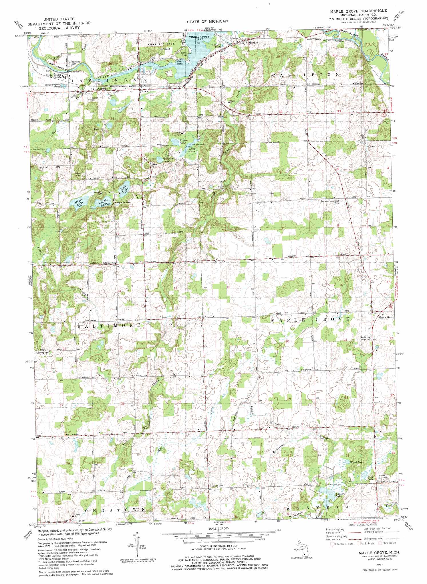
USGS Topo Quad 42085e2 - 1:24,000 scale
| Topo Map Name: | Maple Grove |
| USGS Topo Quad ID: | 42085e2 |
| Print Size: | ca. 21 1/4" wide x 27" high |
| Southeast Coordinates: | 42.5° N latitude / 85.125° W longitude |
| Map Center Coordinates: | 42.5625° N latitude / 85.1875° W longitude |
| U.S. State: | MI |
| Filename: | o42085e2.jpg |
| Download Map JPG Image: | Maple Grove topo map 1:24,000 scale |
| Map Type: | Topographic |
| Topo Series: | 7.5´ |
| Map Scale: | 1:24,000 |
| Source of Map Images: | United States Geological Survey (USGS) |
| Alternate Map Versions: |
Maple Grove MI 1981, updated 1981 Download PDF Buy paper map Maple Grove MI 2011 Download PDF Buy paper map Maple Grove MI 2014 Download PDF Buy paper map Maple Grove MI 2016 Download PDF Buy paper map |
1:24,000 Topo Quads surrounding Maple Grove
Alto |
Freeport |
Lake Odessa |
Woodbury |
Portland South |
Middleville |
Hastings |
Woodland |
Saubee Lake |
Hoytville |
Cloverdale |
Dowling |
Maple Grove |
Nashville |
Chester |
Delton |
Banfield |
Bedford |
Bellevue |
Olivet |
Galesburg |
Augusta |
Battle Creek |
Ceresco |
Marshall |
> Back to 42085e1 at 1:100,000 scale
> Back to 42084a1 at 1:250,000 scale
> Back to U.S. Topo Maps home
Maple Grove topo map: Gazetteer
Maple Grove: Lakes
Ellis Lake elevation 276m 905′Ellison Lake elevation 253m 830′
Gregory Lake elevation 256m 839′
Hall Lake elevation 263m 862′
Long Lake elevation 253m 830′
Middle Lake elevation 263m 862′
Mixer Lake elevation 262m 859′
Taylor Lake elevation 272m 892′
Wild Lake elevation 277m 908′
Maple Grove: Parks
Barryville Historical Marker elevation 287m 941′Charlton Park elevation 243m 797′
Indian Landing-Charlton Park Historical Marker elevation 245m 803′
Maple Grove: Populated Places
Barry's Resort and Mobile Home Park elevation 247m 810′Maple Grove elevation 296m 971′
Morgan elevation 247m 810′
Qumby elevation 247m 810′
Thornapple Lake Estates Mobile Home Park elevation 242m 793′
Maple Grove: Post Offices
Barryville Post Office (historical) elevation 259m 849′Highbank Post Office (historical) elevation 286m 938′
Maple Grove Post Office (historical) elevation 296m 971′
Morgan Post Office (historical) elevation 247m 810′
Quimby Post Office (historical) elevation 247m 810′
Maple Grove: Streams
Cedar Creek elevation 242m 793′High Bank Creek elevation 241m 790′
Squaw Brook elevation 283m 928′
Maple Grove digital topo map on disk
Buy this Maple Grove topo map showing relief, roads, GPS coordinates and other geographical features, as a high-resolution digital map file on DVD:
Northern Illinois, Northern Indiana & Southwestern Michigan
Buy digital topo maps: Northern Illinois, Northern Indiana & Southwestern Michigan