Dowling Topo Map Michigan
To zoom in, hover over the map of Dowling
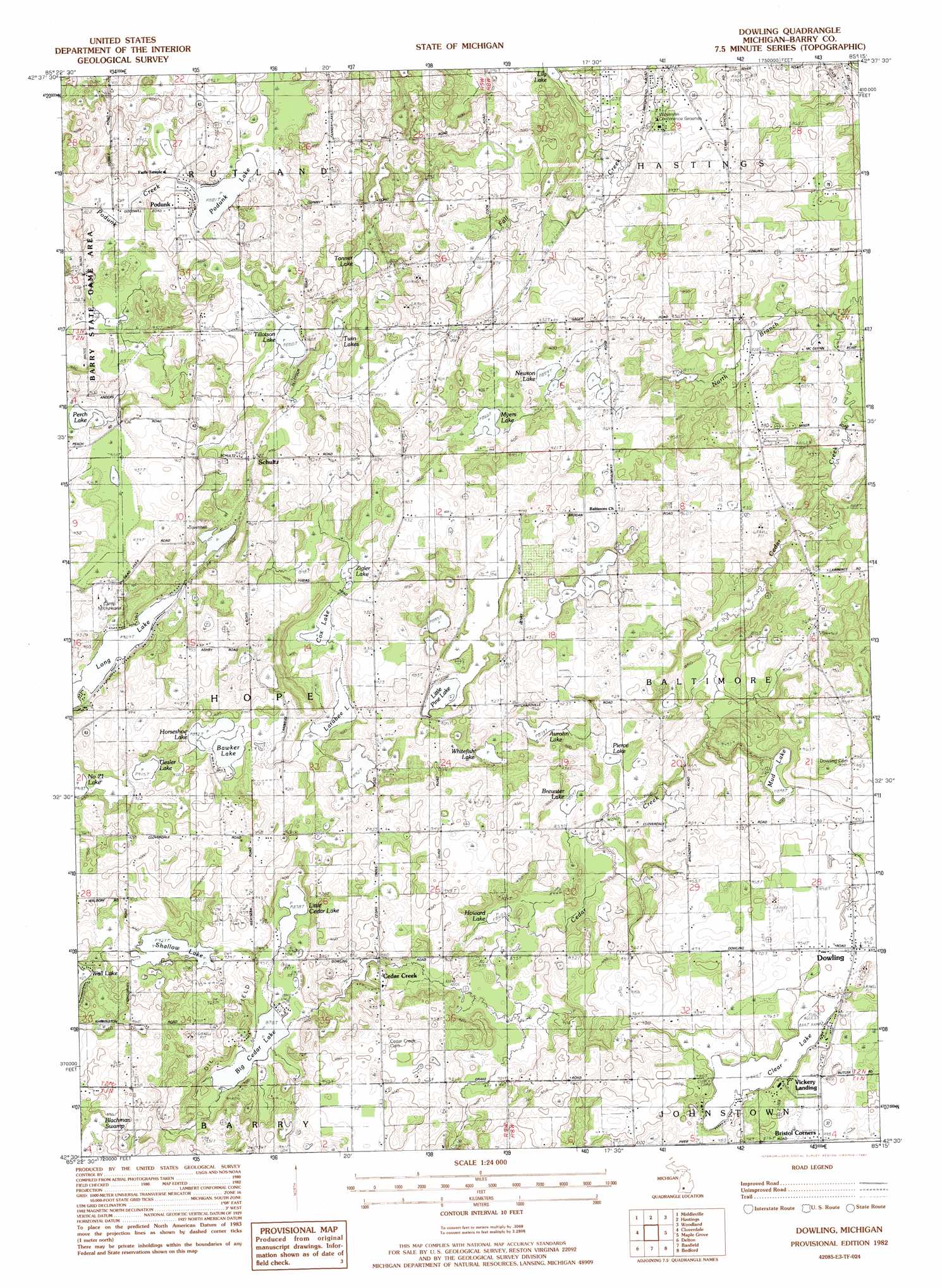
USGS Topo Quad 42085e3 - 1:24,000 scale
| Topo Map Name: | Dowling |
| USGS Topo Quad ID: | 42085e3 |
| Print Size: | ca. 21 1/4" wide x 27" high |
| Southeast Coordinates: | 42.5° N latitude / 85.25° W longitude |
| Map Center Coordinates: | 42.5625° N latitude / 85.3125° W longitude |
| U.S. State: | MI |
| Filename: | o42085e3.jpg |
| Download Map JPG Image: | Dowling topo map 1:24,000 scale |
| Map Type: | Topographic |
| Topo Series: | 7.5´ |
| Map Scale: | 1:24,000 |
| Source of Map Images: | United States Geological Survey (USGS) |
| Alternate Map Versions: |
Dowling MI 1982, updated 1982 Download PDF Buy paper map Dowling MI 2011 Download PDF Buy paper map Dowling MI 2014 Download PDF Buy paper map Dowling MI 2017 Download PDF Buy paper map |
1:24,000 Topo Quads surrounding Dowling
Caledonia |
Alto |
Freeport |
Lake Odessa |
Woodbury |
Bowens Mill |
Middleville |
Hastings |
Woodland |
Saubee Lake |
Orangeville |
Cloverdale |
Dowling |
Maple Grove |
Nashville |
Kalamazoo Ne |
Delton |
Banfield |
Bedford |
Bellevue |
Kalamazoo |
Galesburg |
Augusta |
Battle Creek |
Ceresco |
> Back to 42085e1 at 1:100,000 scale
> Back to 42084a1 at 1:250,000 scale
> Back to U.S. Topo Maps home
Dowling topo map: Gazetteer
Dowling: Lakes
Aurohn Lake elevation 267m 875′Bawker Lake elevation 272m 892′
Big Cedar Lake elevation 267m 875′
Brewster Lake elevation 260m 853′
Clear Lake elevation 287m 941′
Cox Lake elevation 269m 882′
Gesler Lake elevation 279m 915′
Horseshoe Lake elevation 272m 892′
Howard Lake elevation 262m 859′
Larabee Lake elevation 269m 882′
Lily Lake elevation 257m 843′
Little Cedar Lake elevation 267m 875′
Little Pine Lake elevation 272m 892′
Long Lake elevation 277m 908′
Mud Lake elevation 274m 898′
Myers Lake elevation 264m 866′
Newton Lake elevation 262m 859′
Perch Lake elevation 275m 902′
Pierce Lake elevation 261m 856′
Podunk Lake elevation 268m 879′
Shallow Lake elevation 282m 925′
Tanner Lake elevation 269m 882′
Tillotson Lake elevation 268m 879′
Twin Lakes elevation 270m 885′
Whitefish Lake elevation 275m 902′
Zigler Lake elevation 269m 882′
Dowling: Parks
Hope Township District Number Four School Historical Marker elevation 281m 921′Dowling: Populated Places
Cedar Creek elevation 279m 915′Dowling elevation 291m 954′
Podunk elevation 277m 908′
Schultz elevation 286m 938′
Vickery Landing elevation 290m 951′
Dowling: Post Offices
Cedarcreek Post Office (historical) elevation 279m 915′Dowling Post Office elevation 292m 958′
Pritchardville Post Office (historical) elevation 263m 862′
Shultz Post Office (historical) elevation 286m 938′
Dowling: Streams
Kellie Creek elevation 249m 816′North Branch Cedar Creek elevation 247m 810′
Dowling digital topo map on disk
Buy this Dowling topo map showing relief, roads, GPS coordinates and other geographical features, as a high-resolution digital map file on DVD:
Northern Illinois, Northern Indiana & Southwestern Michigan
Buy digital topo maps: Northern Illinois, Northern Indiana & Southwestern Michigan