Martin Topo Map Michigan
To zoom in, hover over the map of Martin
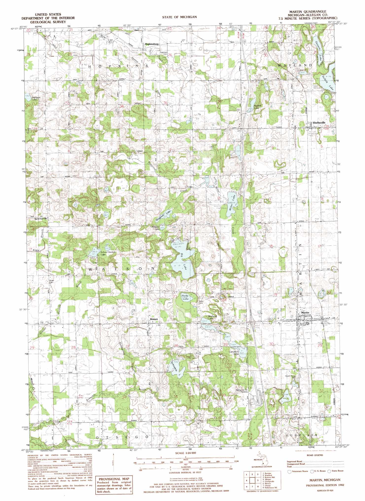
USGS Topo Quad 42085e6 - 1:24,000 scale
| Topo Map Name: | Martin |
| USGS Topo Quad ID: | 42085e6 |
| Print Size: | ca. 21 1/4" wide x 27" high |
| Southeast Coordinates: | 42.5° N latitude / 85.625° W longitude |
| Map Center Coordinates: | 42.5625° N latitude / 85.6875° W longitude |
| U.S. State: | MI |
| Filename: | o42085e6.jpg |
| Download Map JPG Image: | Martin topo map 1:24,000 scale |
| Map Type: | Topographic |
| Topo Series: | 7.5´ |
| Map Scale: | 1:24,000 |
| Source of Map Images: | United States Geological Survey (USGS) |
| Alternate Map Versions: |
Martin MI 1982, updated 1982 Download PDF Buy paper map Martin MI 2011 Download PDF Buy paper map Martin MI 2014 Download PDF Buy paper map Martin MI 2016 Download PDF Buy paper map |
1:24,000 Topo Quads surrounding Martin
Hudsonville West |
Hudsonville East |
Cutlerville |
Caledonia |
Alto |
Hamilton East |
Burnips |
Wayland |
Bowens Mill |
Middleville |
Millgrove |
Allegan |
Martin |
Orangeville |
Cloverdale |
Bloomingdale |
Merson |
Otsego |
Kalamazoo Ne |
Delton |
Gobles West |
Gobles East |
Kalamazoo Sw |
Kalamazoo |
Galesburg |
> Back to 42085e1 at 1:100,000 scale
> Back to 42084a1 at 1:250,000 scale
> Back to U.S. Topo Maps home
Martin topo map: Gazetteer
Martin: Canals
Goldspring Drain elevation 237m 777′Spring Run Drain elevation 231m 757′
Martin: Crossings
Interchange 55 elevation 258m 846′Interchange 59 elevation 237m 777′
Martin: Lakes
Big Lake elevation 241m 790′Buskirk Lake elevation 232m 761′
Caruthers Lake elevation 247m 810′
Geneva Lake elevation 248m 813′
Hicks Lake elevation 249m 816′
Ingerson Lake elevation 219m 718′
Miller Lake elevation 231m 757′
Pickerel Lake elevation 234m 767′
Schnable Lake elevation 231m 757′
School Section Lake elevation 224m 734′
Selkirk Lake elevation 242m 793′
Shagnasty Lake elevation 233m 764′
Wetheral Lake elevation 248m 813′
Martin: Populated Places
Country Meadows Mobile Home Community elevation 256m 839′Hopkinsburg elevation 223m 731′
Little Gem Mobile Home Court elevation 250m 820′
Martin elevation 253m 830′
Shelbyville elevation 252m 826′
Watson elevation 247m 810′
Martin: Post Offices
Martin Post Office elevation 253m 830′Monteith Post Office (historical) elevation 250m 820′
Shelbyville Post Office elevation 252m 826′
Watson Post Office (historical) elevation 247m 810′
Martin: Streams
Butternut Creek elevation 232m 761′Martin digital topo map on disk
Buy this Martin topo map showing relief, roads, GPS coordinates and other geographical features, as a high-resolution digital map file on DVD:
Northern Illinois, Northern Indiana & Southwestern Michigan
Buy digital topo maps: Northern Illinois, Northern Indiana & Southwestern Michigan