Allegan Topo Map Michigan
To zoom in, hover over the map of Allegan
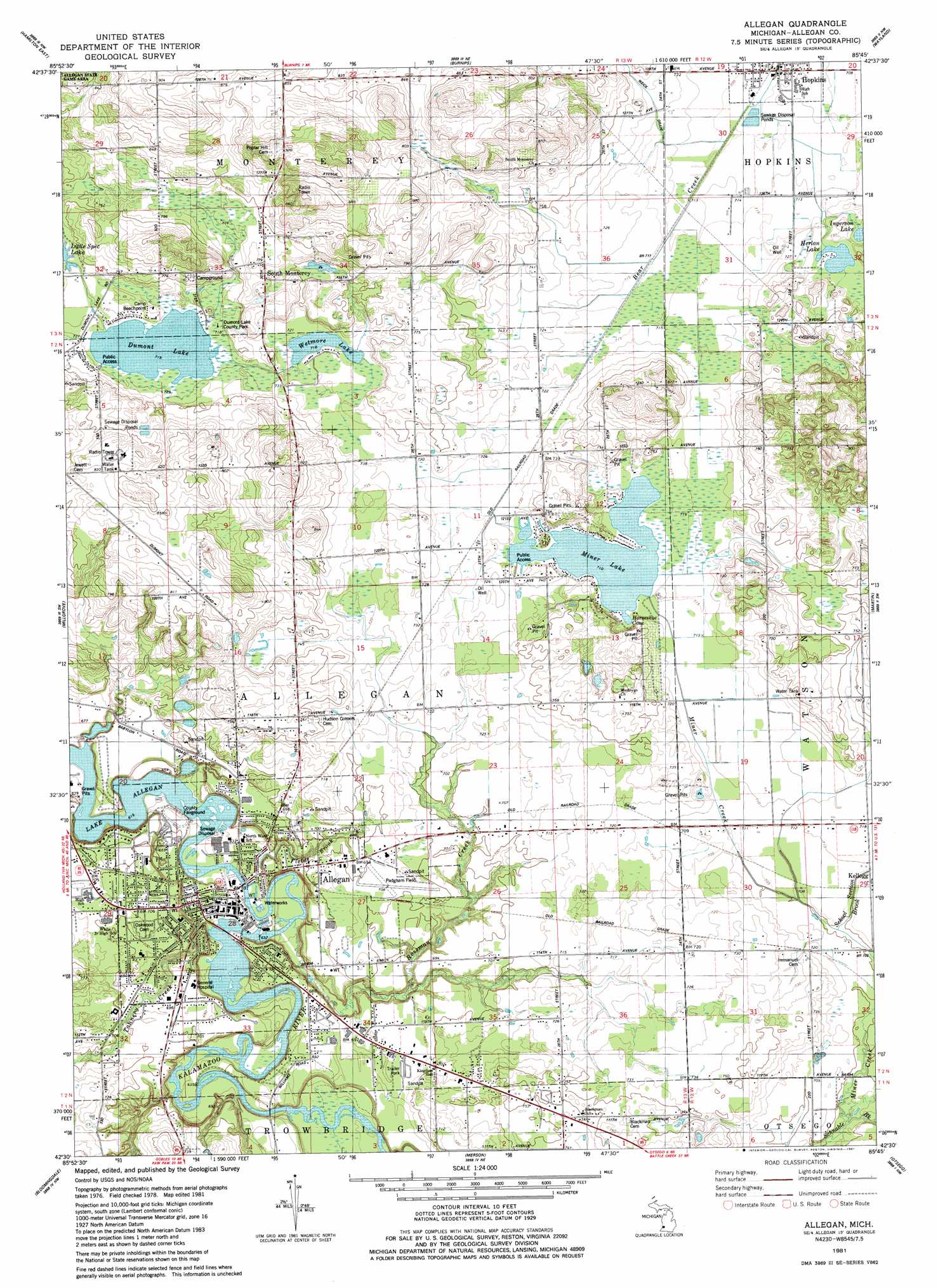
USGS Topo Quad 42085e7 - 1:24,000 scale
| Topo Map Name: | Allegan |
| USGS Topo Quad ID: | 42085e7 |
| Print Size: | ca. 21 1/4" wide x 27" high |
| Southeast Coordinates: | 42.5° N latitude / 85.75° W longitude |
| Map Center Coordinates: | 42.5625° N latitude / 85.8125° W longitude |
| U.S. State: | MI |
| Filename: | o42085e7.jpg |
| Download Map JPG Image: | Allegan topo map 1:24,000 scale |
| Map Type: | Topographic |
| Topo Series: | 7.5´ |
| Map Scale: | 1:24,000 |
| Source of Map Images: | United States Geological Survey (USGS) |
| Alternate Map Versions: |
Allegan MI 1981, updated 1981 Download PDF Buy paper map Allegan MI 2011 Download PDF Buy paper map Allegan MI 2014 Download PDF Buy paper map Allegan MI 2016 Download PDF Buy paper map |
1:24,000 Topo Quads surrounding Allegan
Holland East |
Hudsonville West |
Hudsonville East |
Cutlerville |
Caledonia |
Hamilton West |
Hamilton East |
Burnips |
Wayland |
Bowens Mill |
Fennville |
Millgrove |
Allegan |
Martin |
Orangeville |
Pullman |
Bloomingdale |
Merson |
Otsego |
Kalamazoo Ne |
Bangor |
Gobles West |
Gobles East |
Kalamazoo Sw |
Kalamazoo |
> Back to 42085e1 at 1:100,000 scale
> Back to 42084a1 at 1:250,000 scale
> Back to U.S. Topo Maps home
Allegan topo map: Gazetteer
Allegan: Airports
Padgham Field elevation 215m 705′Allegan: Bays
Horseshoe Cove elevation 216m 708′Allegan: Bridges
Second Street Bridge elevation 192m 629′Allegan: Lakes
Dumont Lake elevation 218m 715′Herlan Lake elevation 220m 721′
Miner Lake elevation 216m 708′
Wetmore Lake elevation 219m 718′
Allegan: Parks
Allegan County Historical Marker elevation 197m 646′Dumont Lake County Park elevation 219m 718′
Episcopal Church of the Good Shepherd Historical Marker elevation 197m 646′
JayCee Park elevation 188m 616′
Mahan Park elevation 193m 633′
Riverfront Park elevation 194m 636′
Rossman Esplanade Park elevation 208m 682′
Second Street Bridge Historical Marker elevation 192m 629′
Sue Lange Memorial Park elevation 207m 679′
Allegan: Populated Places
Allegan elevation 199m 652′Allegan Mobile Estates elevation 197m 646′
Hopkins elevation 217m 711′
South Monterey elevation 236m 774′
Allegan: Post Offices
Abronia Post Office (historical) elevation 218m 715′Allegan Post Office elevation 196m 643′
Hopkins Post Office elevation 215m 705′
Kellogg Post Office (historical) elevation 215m 705′
Minerlake Post Office (historical) elevation 221m 725′
South Monterey Post Office (historical) elevation 236m 774′
Allegan: Streams
Fields Brook elevation 191m 626′Miner Creek elevation 207m 679′
Rossman Creek elevation 187m 613′
School Section Brook elevation 213m 698′
Allegan digital topo map on disk
Buy this Allegan topo map showing relief, roads, GPS coordinates and other geographical features, as a high-resolution digital map file on DVD:
Northern Illinois, Northern Indiana & Southwestern Michigan
Buy digital topo maps: Northern Illinois, Northern Indiana & Southwestern Michigan