Saubee Lake Topo Map Michigan
To zoom in, hover over the map of Saubee Lake
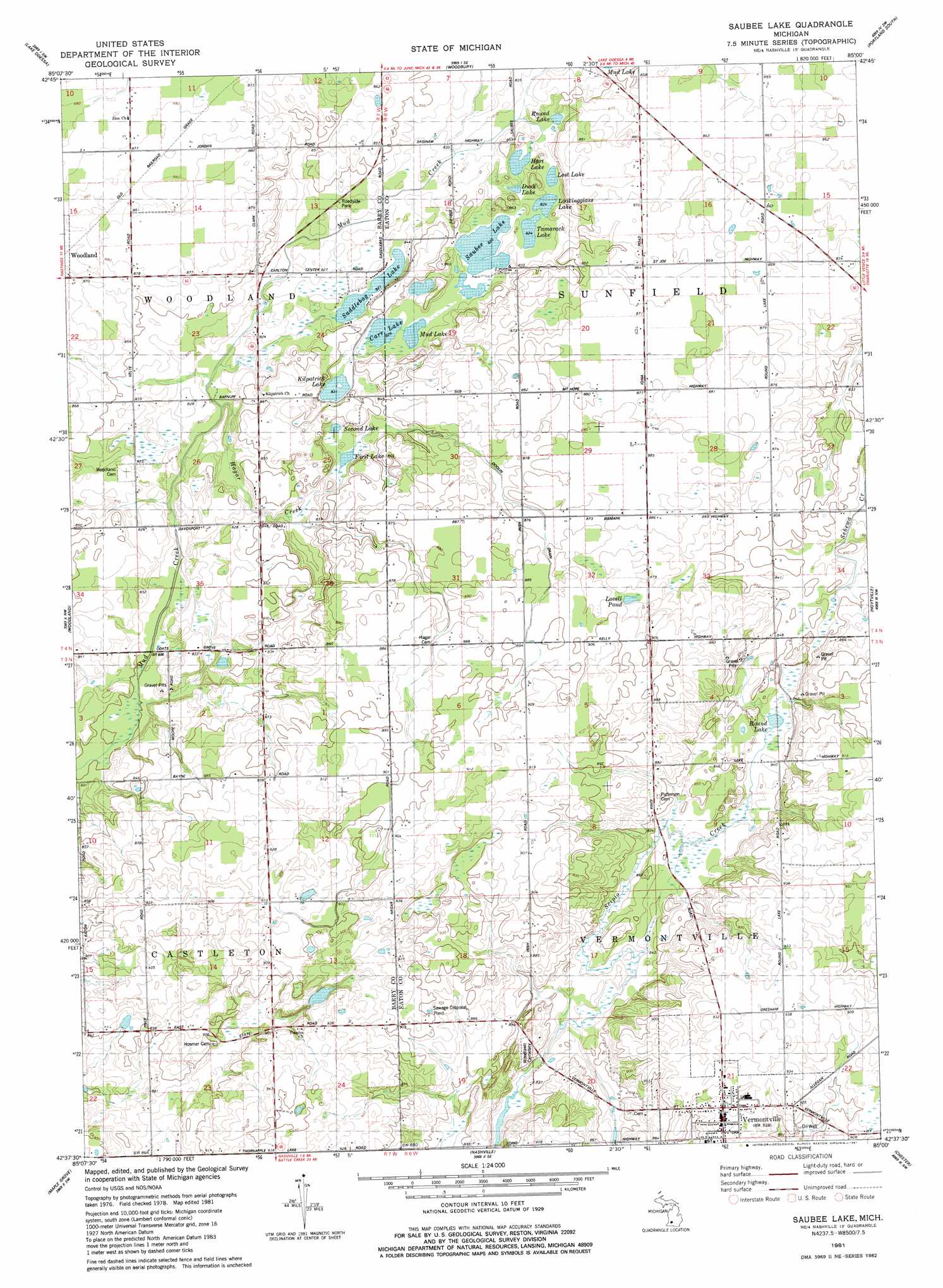
USGS Topo Quad 42085f1 - 1:24,000 scale
| Topo Map Name: | Saubee Lake |
| USGS Topo Quad ID: | 42085f1 |
| Print Size: | ca. 21 1/4" wide x 27" high |
| Southeast Coordinates: | 42.625° N latitude / 85° W longitude |
| Map Center Coordinates: | 42.6875° N latitude / 85.0625° W longitude |
| U.S. State: | MI |
| Filename: | o42085f1.jpg |
| Download Map JPG Image: | Saubee Lake topo map 1:24,000 scale |
| Map Type: | Topographic |
| Topo Series: | 7.5´ |
| Map Scale: | 1:24,000 |
| Source of Map Images: | United States Geological Survey (USGS) |
| Alternate Map Versions: |
Saubee Lake MI 1981, updated 1981 Download PDF Buy paper map Saubee Lake MI 2011 Download PDF Buy paper map Saubee Lake MI 2014 Download PDF Buy paper map Saubee Lake MI 2016 Download PDF Buy paper map |
1:24,000 Topo Quads surrounding Saubee Lake
Lowell |
Saranac |
Ionia |
Portland North |
Wasphalia |
Freeport |
Lake Odessa |
Woodbury |
Portland South |
Eagle |
Hastings |
Woodland |
Saubee Lake |
Hoytville |
Needmore |
Dowling |
Maple Grove |
Nashville |
Chester |
Charlotte |
Banfield |
Bedford |
Bellevue |
Olivet |
Duck Lake |
> Back to 42085e1 at 1:100,000 scale
> Back to 42084a1 at 1:250,000 scale
> Back to U.S. Topo Maps home
Saubee Lake topo map: Gazetteer
Saubee Lake: Lakes
Carr Lake elevation 251m 823′Durk Lake elevation 252m 826′
First Lake elevation 252m 826′
Hart Lake elevation 258m 846′
Kilpatrick Lake elevation 253m 830′
Lookingglass Lake elevation 251m 823′
Lost Lake elevation 253m 830′
Lovell Pond elevation 268m 879′
Mud Lake elevation 252m 826′
Round Lake elevation 255m 836′
Saddlebag Lake elevation 250m 820′
Saubee Lake elevation 250m 820′
Second Lake elevation 252m 826′
Tamarock Lake elevation 251m 823′
Saubee Lake: Parks
Opera House Historical Marker elevation 286m 938′Vermontville Academy Historical Marker elevation 283m 928′
Vermontville City Park elevation 284m 931′
Vermontville United Methodist Church Historical Marker elevation 283m 928′
Saubee Lake: Populated Places
Vermontville elevation 285m 935′Saubee Lake: Post Offices
Bismarck Post Office (historical) elevation 269m 882′Blair Post Office (historical) elevation 253m 830′
Clinton Junction Post Office (historical) elevation 265m 869′
Clinton Junction Post Office (historical) elevation 265m 869′
Dellwood Post Office (historical) elevation 266m 872′
Vermontville Post Office elevation 285m 935′
Saubee Lake: Streams
Hagar Creek elevation 248m 813′Saubee Lake digital topo map on disk
Buy this Saubee Lake topo map showing relief, roads, GPS coordinates and other geographical features, as a high-resolution digital map file on DVD:
Northern Illinois, Northern Indiana & Southwestern Michigan
Buy digital topo maps: Northern Illinois, Northern Indiana & Southwestern Michigan