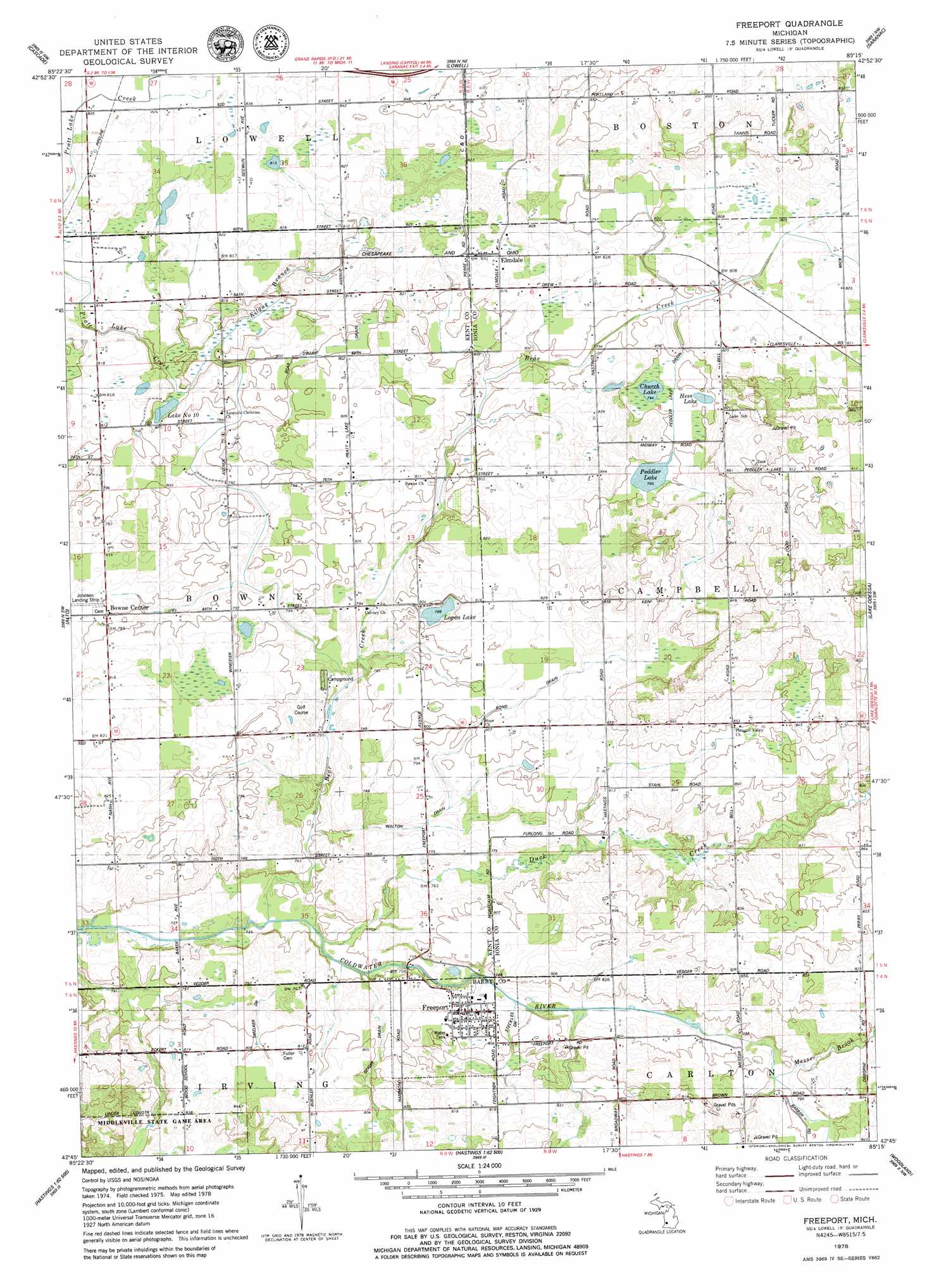
Freeport Topo Map Michigan
To zoom in, hover over the map of Freeport
USGS Topo Quad 42085g3 - 1:24,000 scale
| Topo Map Name: | Freeport |
| USGS Topo Quad ID: | 42085g3 |
| Print Size: | ca. 21 1/4" wide x 27" high |
| Southeast Coordinates: | 42.75° N latitude / 85.25° W longitude |
| Map Center Coordinates: | 42.8125° N latitude / 85.3125° W longitude |
| U.S. State: | MI |
| Filename: | o42085g3.jpg |
| Download Map JPG Image: | Freeport topo map 1:24,000 scale |
| Map Type: | Topographic |
| Topo Series: | 7.5´ |
| Map Scale: | 1:24,000 |
| Source of Map Images: | United States Geological Survey (USGS) |
| Alternate Map Versions: |
Freeport MI 1978, updated 1979 Download PDF Buy paper map Freeport MI 2011 Download PDF Buy paper map Freeport MI 2014 Download PDF Buy paper map Freeport MI 2016 Download PDF Buy paper map |
1:24,000 Topo Quads surrounding Freeport
Rockford |
Cannonsburg |
Smyrna |
Belding |
Shiloh |
Grand Rapids East |
Cascade |
Lowell |
Saranac |
Ionia |
Caledonia |
Alto |
Freeport |
Lake Odessa |
Woodbury |
Bowens Mill |
Middleville |
Hastings |
Woodland |
Saubee Lake |
Orangeville |
Cloverdale |
Dowling |
Maple Grove |
Nashville |
> Back to 42085e1 at 1:100,000 scale
> Back to 42084a1 at 1:250,000 scale
> Back to U.S. Topo Maps home
Freeport topo map: Gazetteer
Freeport: Airports
Johnson Airport elevation 251m 823′Freeport: Canals
Bear Swamp Drain elevation 244m 800′Bond Drain elevation 247m 810′
Geiger Drain elevation 240m 787′
Peddler Lake Drain elevation 244m 800′
Smelker Drain elevation 238m 780′
Stecklee Drain elevation 239m 784′
Walton Drain elevation 234m 767′
Freeport: Lakes
Church Lake elevation 242m 793′Hess Lake elevation 244m 800′
Lake Number Ten elevation 242m 793′
Logan Lake elevation 240m 787′
Peddler Lake elevation 242m 793′
Freeport: Parks
Middleville State Game Area elevation 243m 797′Freeport: Populated Places
Bowne Center elevation 244m 800′Elmdale elevation 253m 830′
Freeport elevation 240m 787′
Freeport: Post Offices
Bowne Post Office (historical) elevation 244m 800′Elmdale Post Office (historical) elevation 253m 830′
Fillmore Post Office (historical) elevation 255m 836′
Freeport Post Office elevation 241m 790′
Logan Post Office (historical) elevation 244m 800′
West Campbell Post Office (historical) elevation 263m 862′
Freeport: Streams
Bear Creek elevation 223m 731′Duck Creek elevation 227m 744′
Kilgus Branch elevation 239m 784′
Messer Brook elevation 239m 784′
Freeport digital topo map on disk
Buy this Freeport topo map showing relief, roads, GPS coordinates and other geographical features, as a high-resolution digital map file on DVD:
Northern Illinois, Northern Indiana & Southwestern Michigan
Buy digital topo maps: Northern Illinois, Northern Indiana & Southwestern Michigan