Grand Rapids West Topo Map Michigan
To zoom in, hover over the map of Grand Rapids West
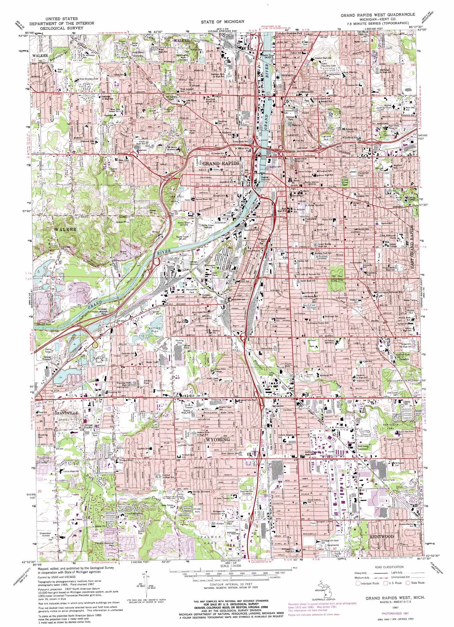
USGS Topo Quad 42085h6 - 1:24,000 scale
| Topo Map Name: | Grand Rapids West |
| USGS Topo Quad ID: | 42085h6 |
| Print Size: | ca. 21 1/4" wide x 27" high |
| Southeast Coordinates: | 42.875° N latitude / 85.625° W longitude |
| Map Center Coordinates: | 42.9375° N latitude / 85.6875° W longitude |
| U.S. State: | MI |
| Filename: | o42085h6.jpg |
| Download Map JPG Image: | Grand Rapids West topo map 1:24,000 scale |
| Map Type: | Topographic |
| Topo Series: | 7.5´ |
| Map Scale: | 1:24,000 |
| Source of Map Images: | United States Geological Survey (USGS) |
| Alternate Map Versions: |
Grand Rapids West MI 1967, updated 1969 Download PDF Buy paper map Grand Rapids West MI 1967, updated 1973 Download PDF Buy paper map Grand Rapids West MI 1967, updated 1981 Download PDF Buy paper map Grand Rapids West MI 1967, updated 1982 Download PDF Buy paper map Grand Rapids West MI 1996, updated 1999 Download PDF Buy paper map Grand Rapids West MI 2011 Download PDF Buy paper map Grand Rapids West MI 2014 Download PDF Buy paper map Grand Rapids West MI 2017 Download PDF Buy paper map |
1:24,000 Topo Quads surrounding Grand Rapids West
Ravenna |
Casnovia |
Sparta |
Cedar Springs |
Evans |
Coopersville |
Marne |
Cedar Springs Sw |
Rockford |
Cannonsburg |
Allendale |
Grandville |
Grand Rapids West |
Grand Rapids East |
Cascade |
Hudsonville West |
Hudsonville East |
Cutlerville |
Caledonia |
Alto |
Hamilton East |
Burnips |
Wayland |
Bowens Mill |
Middleville |
> Back to 42085e1 at 1:100,000 scale
> Back to 42084a1 at 1:250,000 scale
> Back to U.S. Topo Maps home
Grand Rapids West topo map: Gazetteer
Grand Rapids West: Airports
Amway Downtown Heliport elevation 188m 616′Butterworth Hospital Heliport elevation 222m 728′
Saint Marys Hospital Heliport elevation 201m 659′
Sumner Heliport elevation 221m 725′
Grand Rapids West: Crossings
Interchange 72 elevation 183m 600′Interchange 73 elevation 190m 623′
Interchange 75 elevation 224m 734′
Interchange 76 elevation 193m 633′
Interchange 77A elevation 188m 616′
Interchange 77B elevation 188m 616′
Interchange 77C elevation 201m 659′
Interchange 78 elevation 216m 708′
Interchange 79 elevation 207m 679′
Interchange 79 elevation 219m 718′
Interchange 80 elevation 204m 669′
Interchange 81 elevation 207m 679′
Interchange 82 elevation 196m 643′
Interchange 83A elevation 202m 662′
Interchange 83B elevation 199m 652′
Interchange 84 elevation 193m 633′
Interchange 85A elevation 193m 633′
Interchange 85B elevation 187m 613′
Interchange 86 elevation 190m 623′
Interchange 87 elevation 191m 626′
Interchange 88 elevation 191m 626′
Grand Rapids West: Lakes
Battjes Lake elevation 186m 610′Lamar Lake elevation 181m 593′
Luvis Lake elevation 184m 603′
Porter Lake elevation 183m 600′
Grand Rapids West: Parks
Ah-Nab-Awen-Park elevation 183m 600′Aquinas College Historical Marker elevation 231m 757′
Arthur Hendrick Vandenberg Historical Marker elevation 188m 616′
Battjes Park elevation 184m 603′
Baw-wa-ting Historical Marker elevation 181m 593′
Belknap Park elevation 211m 692′
Blandford Nature Center elevation 223m 731′
Briggs Park elevation 201m 659′
Buck Creek Nature Preserve elevation 196m 643′
Burgis Park elevation 206m 675′
Calvin Crest Park elevation 194m 636′
Campus Park elevation 201m 659′
Canal Street Park elevation 186m 610′
Central High School Historical Marker elevation 227m 744′
Central Reformed Church Historical Marker elevation 223m 731′
Charles Lemery Park elevation 196m 643′
Coit Park elevation 193m 633′
Ferrand Memorial Park elevation 213m 698′
First (Park) Congregational Church - Second Historical Marker elevation 199m 652′
First (Park) Congregational Church Historical Marker elevation 199m 652′
Fish Ladder Park elevation -1m -4′
Fortieth Street Park elevation 203m 666′
Franklin Park elevation 231m 757′
Fuller Park elevation 219m 718′
Furniture Industry Historical Marker elevation 183m 600′
Garfield Park elevation 207m 679′
George P. Tilma Nature Preserve elevation 221m 725′
Gerald R Ford Boyhood Home Historical Marker elevation 217m 711′
Grant Park elevation 189m 620′
Harrison Park elevation 188m 616′
Highland Park elevation 204m 669′
Hillcroft Park elevation 202m 662′
Home Acres Park elevation 208m 682′
Hopewell Indian Mounds Park elevation 181m 593′
Houseman Field elevation 218m 715′
Jackson Park elevation 207m 679′
John Ball Park elevation 191m 626′
Ken-O-Sha Park elevation 206m 675′
Kimball Stadium elevation 186m 610′
Ladies Literary Club Historical Marker elevation 197m 646′
Lamar Park elevation 184m 603′
Lincoln Park elevation 186m 610′
Linda Park elevation 223m 731′
Lions Park elevation 207m 679′
MacKay Jaycees Park elevation 214m 702′
Marquette Park elevation 186m 610′
Martin Luther King Park elevation 231m 757′
Mary Waters Park elevation 215m 705′
Mathias Alten Historical Marker elevation 228m 748′
Mathias Alten Home and Studio Historical Marker elevation 228m 748′
May House Historical Marker elevation 213m 698′
McCabe-Marlowe House Historical Marker elevation 223m 731′
Mulick Park elevation 227m 744′
One Hundred Twenty-Sixth Infantry Historical Marker elevation 206m 675′
Oriole Park elevation 201m 659′
Palmer Park elevation 197m 646′
Pinery Park elevation 191m 626′
Plaster Creek Family Park elevation 194m 636′
Prairie Park elevation 193m 633′
President Gerald R Ford Historical Marker elevation 217m 711′
Richmond Park elevation 209m 685′
Roberto Clemente Park elevation 187m 613′
Roosevelt Park elevation 196m 643′
Rosa Parks Circle elevation 188m 616′
Saint Andrew's Cemetery Historical Marker elevation 215m 705′
Shawmut Hills Park elevation 230m 754′
Sixth Street Bridge Historical Marker elevation 183m 600′
Sixth Street Park elevation 187m 613′
South Field elevation 204m 669′
South Lawn Park elevation 208m 682′
Summerwood Park elevation 212m 695′
The Castle Historical Marker elevation 219m 718′
Valley City Milling Company Historical Marker elevation 183m 600′
Valley Field elevation 188m 616′
Vandenberg Center Historical Marker elevation 188m 616′
Veterans Memorial Park elevation 198m 649′
Veteran's Memorial Park elevation 208m 682′
Villa Maria Historical Marker elevation 196m 643′
Voight House Historical Marker elevation 224m 734′
Wilcox Park elevation 225m 738′
Grand Rapids West: Populated Places
Chateau Ferrand Estates Mobile Home Park elevation 203m 666′Country Estates Mobile Home Park elevation 207m 679′
Grand Rapids elevation 195m 639′
Paris Estates Mobile Home Park elevation 208m 682′
Windmill Pointe Mobile Home Park elevation 207m 679′
Wyoming elevation 196m 643′
Grand Rapids West: Post Offices
Crosby Post Office (historical) elevation 226m 741′Grand Rapids Post Office elevation 187m 613′
Paris Post Office (historical) elevation 212m 695′
Wyoming Post Office (historical) elevation 208m 682′
Grand Rapids West: Reservoirs
Lake Leota elevation 181m 593′Grand Rapids West: Streams
Indian Mill Creek elevation 183m 600′Plaster Creek elevation 179m 587′
Grand Rapids West digital topo map on disk
Buy this Grand Rapids West topo map showing relief, roads, GPS coordinates and other geographical features, as a high-resolution digital map file on DVD:
Northern Illinois, Northern Indiana & Southwestern Michigan
Buy digital topo maps: Northern Illinois, Northern Indiana & Southwestern Michigan