Highland Park Topo Map Illinois
To zoom in, hover over the map of Highland Park
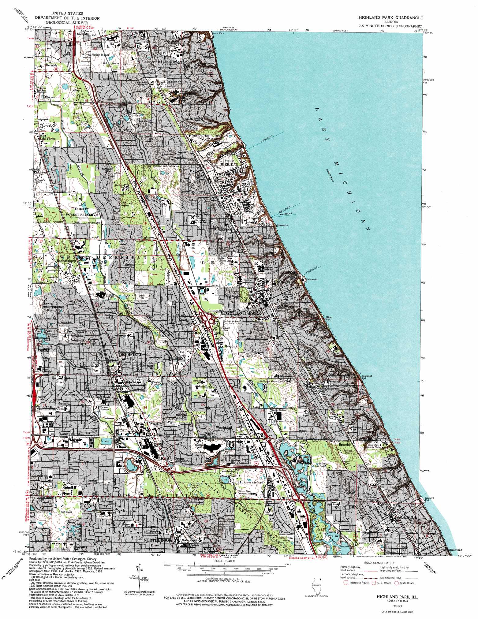
USGS Topo Quad 42087b7 - 1:24,000 scale
| Topo Map Name: | Highland Park |
| USGS Topo Quad ID: | 42087b7 |
| Print Size: | ca. 21 1/4" wide x 27" high |
| Southeast Coordinates: | 42.125° N latitude / 87.75° W longitude |
| Map Center Coordinates: | 42.1875° N latitude / 87.8125° W longitude |
| U.S. State: | IL |
| Filename: | o42087b7.jpg |
| Download Map JPG Image: | Highland Park topo map 1:24,000 scale |
| Map Type: | Topographic |
| Topo Series: | 7.5´ |
| Map Scale: | 1:24,000 |
| Source of Map Images: | United States Geological Survey (USGS) |
| Alternate Map Versions: |
Highland Park IL 1928 Download PDF Buy paper map Highland Park IL 1928, updated 1930 Download PDF Buy paper map Highland Park IL 1928, updated 1938 Download PDF Buy paper map Highland Park IL 1928, updated 1948 Download PDF Buy paper map Highland Park IL 1951 Download PDF Buy paper map Highland Park IL 1953, updated 1955 Download PDF Buy paper map Highland Park IL 1963, updated 1964 Download PDF Buy paper map Highland Park IL 1963, updated 1973 Download PDF Buy paper map Highland Park IL 1963, updated 1981 Download PDF Buy paper map Highland Park IL 1993, updated 1993 Download PDF Buy paper map Highland Park IL 2000, updated 2001 Download PDF Buy paper map Highland Park IL 2012 Download PDF Buy paper map Highland Park IL 2015 Download PDF Buy paper map |
1:24,000 Topo Quads surrounding Highland Park
Antioch |
Wadsworth |
Zion |
||
Grayslake |
Libertyville |
Waukegan |
||
Lake Zurich |
Wheeling |
Highland Park |
||
Palatine |
Arlington Heights |
Park Ridge |
Evanston |
|
Lombard |
Elmhurst |
River Forest |
Chicago Loop |
> Back to 42087a1 at 1:100,000 scale
> Back to 42086a1 at 1:250,000 scale
> Back to U.S. Topo Maps home
Highland Park topo map: Gazetteer
Highland Park: Airports
Gieser Heliport elevation 196m 643′Highland Park: Crossings
Interchange 29 elevation 196m 643′Interchange 30 elevation 195m 639′
Highland Park: Parks
Briarwood Park elevation 200m 656′Buckthorn Park elevation 196m 643′
Buena Park elevation 206m 675′
Centennial Park elevation 197m 646′
Central Park elevation 200m 656′
Chicago Botanical Gardens elevation 194m 636′
Clavery Park elevation 204m 669′
Cloverdale Park elevation 198m 649′
Coast Guard Park elevation 201m 659′
Crestwood Park elevation 205m 672′
Cumnor Court Park elevation 199m 652′
Deer Spring Park elevation 204m 669′
Deerpath Community Park elevation 203m 666′
Devonshire Park elevation 199m 652′
Estates Tot Lot elevation 199m 652′
Farwell Field elevation 207m 679′
Glenbrook Countryside Park elevation 206m 675′
Greenfield Park elevation 202m 662′
Heller Park elevation 203m 666′
Highmoor Park elevation 200m 656′
Highmoor Park Nature Preserve elevation 200m 656′
Hillside Park elevation 206m 675′
Hybernia Nature Preserve elevation 198m 649′
Idlewild Park elevation 206m 675′
Indian Ridge Park elevation 209m 685′
James C Mitchell Park elevation 202m 662′
Jaycee Memorial Park elevation 201m 659′
Jewett Park elevation 206m 675′
John Blumberg Park elevation 203m 666′
John F Kennedy Park elevation 196m 643′
Keller Park elevation 199m 652′
Kipling Park elevation 211m 692′
Laurel Park elevation 207m 679′
Leonardi Park elevation 196m 643′
Lincoln Park elevation 213m 698′
Lincoln Place Park elevation 209m 685′
Longview Park elevation 206m 675′
Manot Park elevation 194m 636′
Maplewood Park elevation 201m 659′
McCormick Woods Nature Preserve elevation 203m 666′
Memorial Park elevation 208m 682′
Millard Park elevation 198m 649′
Mooney Park elevation 203m 666′
Moraine Park elevation 199m 652′
Moroney Park elevation 204m 669′
North Field Park elevation 204m 669′
Northcroft Park elevation 210m 688′
Old Elm Park elevation 213m 698′
Olson Park elevation 202m 662′
Park Avenue Park elevation 182m 597′
Pine Street Park elevation 201m 659′
Port Clinton Park elevation 200m 656′
Prairie Wolf Slough County Forest Preserve elevation 203m 666′
Ravinia Park elevation 207m 679′
Roger Williams Park elevation 205m 672′
Rosewood Park elevation 196m 643′
Shelton Park elevation 204m 669′
Shepard Park elevation 202m 662′
Sherwood Park elevation 209m 685′
Sherwood Park elevation 198m 649′
Sleepy Hollow Park elevation 195m 639′
Snyder Park elevation 204m 669′
Somme Prairie Nature Preserve elevation 198m 649′
South Park elevation 212m 695′
South Park elevation 206m 675′
Sunset Woods Park elevation 206m 675′
Trail Tree Park elevation 199m 652′
Village Green elevation 196m 643′
Walden Park elevation 204m 669′
Waveland Park elevation 202m 662′
Westridge Park elevation 199m 652′
Williamsburg Square Park elevation 200m 656′
Wilmot Park elevation 202m 662′
Woodland Park elevation 208m 682′
Woodridge Park elevation 198m 649′
Highland Park: Populated Places
Ancient Tree elevation 209m 685′Bachs Addition elevation 203m 666′
Bannockburn elevation 209m 685′
Blodgett elevation 201m 659′
Bradless Subdivision elevation 210m 688′
Braeside elevation 207m 679′
Briarwood Glen elevation 203m 666′
Bridlewood Lane elevation 206m 675′
Briergate elevation 194m 636′
Briergate Station elevation 195m 639′
Brookside Estates elevation 202m 662′
Buttonwood elevation 205m 672′
Carlye Subdivision elevation 210m 688′
Chapel Hill Estates elevation 207m 679′
Charlemagne East elevation 209m 685′
Charring Cross elevation 199m 652′
Clarke's Subdivision elevation 198m 649′
Colonial Village elevation 208m 682′
Coral Manor elevation 210m 688′
Cotswald Subdivision elevation 200m 656′
Dean-Horsch Subdivision elevation 205m 672′
Deerfield elevation 209m 685′
Deerpath elevation 204m 669′
Del Mar Woods elevation 201m 659′
Dundee Road Acres elevation 201m 659′
Dunsten Green elevation 201m 659′
Estates of Charlemagne elevation 209m 685′
Everett elevation 208m 682′
Evergreen Subdivision elevation 209m 685′
Fair Acres elevation 198m 649′
Fair Meadows elevation 198m 649′
Fair Oaks elevation 193m 633′
Garden Court elevation 204m 669′
Glenbrook Countryside elevation 204m 669′
Glencoe elevation 205m 672′
Grace Manor elevation 205m 672′
Greenbriar Highlands elevation 201m 659′
Heart O' Northbrook elevation 196m 643′
Highland Park elevation 212m 695′
Highlands elevation 200m 656′
Highmoor elevation 205m 672′
Highwood elevation 206m 675′
Huntington elevation 202m 662′
Innisfail elevation 205m 672′
Kennedy elevation 209m 685′
Kinchester Lane Subdivision elevation 204m 669′
Kingsport Court elevation 207m 679′
Lane Park elevation 194m 636′
Lee Acres elevation 199m 652′
Lee Woods elevation 202m 662′
Linden Ridge elevation 203m 666′
Little Orchard Subdivision elevation 196m 643′
Lone Tree Subdivision elevation 209m 685′
Manus North Shore Estates elevation 203m 666′
Maple Ridge elevation 201m 659′
Markus Subdivision elevation 206m 675′
Marlen Subdivision elevation 205m 672′
Meyer's Subdivision elevation 196m 643′
Mission Hills Estates elevation 202m 662′
Northbrook elevation 197m 646′
Northbrook Colonial Estates elevation 207m 679′
Northbrook East elevation 196m 643′
Northbrook Estates elevation 202m 662′
Northbrook Gardens elevation 201m 659′
Northbrook Glen elevation 204m 669′
Northbrook Heights elevation 204m 669′
Northbrook Highlands elevation 200m 656′
Northbrook Manor elevation 195m 639′
Northbrook Mews elevation 201m 659′
Northbrook Oaks elevation 200m 656′
Northbrook Villa elevation 198m 649′
Northfield Acres elevation 201m 659′
Northwood Edens elevation 193m 633′
Old Colony Court elevation 201m 659′
Olson's Subdivision elevation 201m 659′
Oury Point elevation 206m 675′
Pheasant Creek elevation 205m 672′
Ravinia elevation 209m 685′
Red Haw Ridge elevation 201m 659′
Ridgecroft elevation 209m 685′
Rugen Subdivision elevation 200m 656′
Saint Stephens Green elevation 201m 659′
Shermer Ridge elevation 208m 682′
Shermer Square elevation 207m 679′
Shermerville elevation 197m 646′
Skokie Highlands elevation 195m 639′
Skokie Manor elevation 206m 675′
Sportmans Cove elevation 207m 679′
Star Subdivision elevation 204m 669′
Sunridge elevation 196m 643′
Sycamore Lane elevation 196m 643′
The Colonnades elevation 197m 646′
Thorn Hill elevation 201m 659′
Tiber Hill Estates elevation 204m 669′
Timber Lane elevation 203m 666′
Timber Ridge elevation 207m 679′
Villas of Northbrook elevation 203m 666′
Ville Du Parc elevation 207m 679′
Water Edge Subdivision elevation 198m 649′
Weller's Subdivision elevation 205m 672′
West Lake Forest elevation 207m 679′
White Plains elevation 203m 666′
Wildebrook On The Green elevation 211m 692′
Williamsburg Square elevation 201m 659′
Wilshire Terrace elevation 201m 659′
Woodlands elevation 203m 666′
Woodridge elevation 199m 652′
Highland Park: Post Offices
Glencoe Post Office elevation 204m 669′Highland Park Main Post Office elevation 212m 695′
Highwood Post Office elevation 210m 688′
Northbrook Post Office elevation 201m 659′
Ravinia Station Highland Park Post Office elevation 205m 672′
Highland Park: Reservoirs
Lake Eleanor elevation 200m 656′Highland Park: Woods
Chipilly Woods elevation 201m 659′Somme Woods elevation 204m 669′
Sunset Ridge Woods elevation 197m 646′
Turnbull Woods elevation 208m 682′
Highland Park digital topo map on disk
Buy this Highland Park topo map showing relief, roads, GPS coordinates and other geographical features, as a high-resolution digital map file on DVD:
Northern Illinois, Northern Indiana & Southwestern Michigan
Buy digital topo maps: Northern Illinois, Northern Indiana & Southwestern Michigan