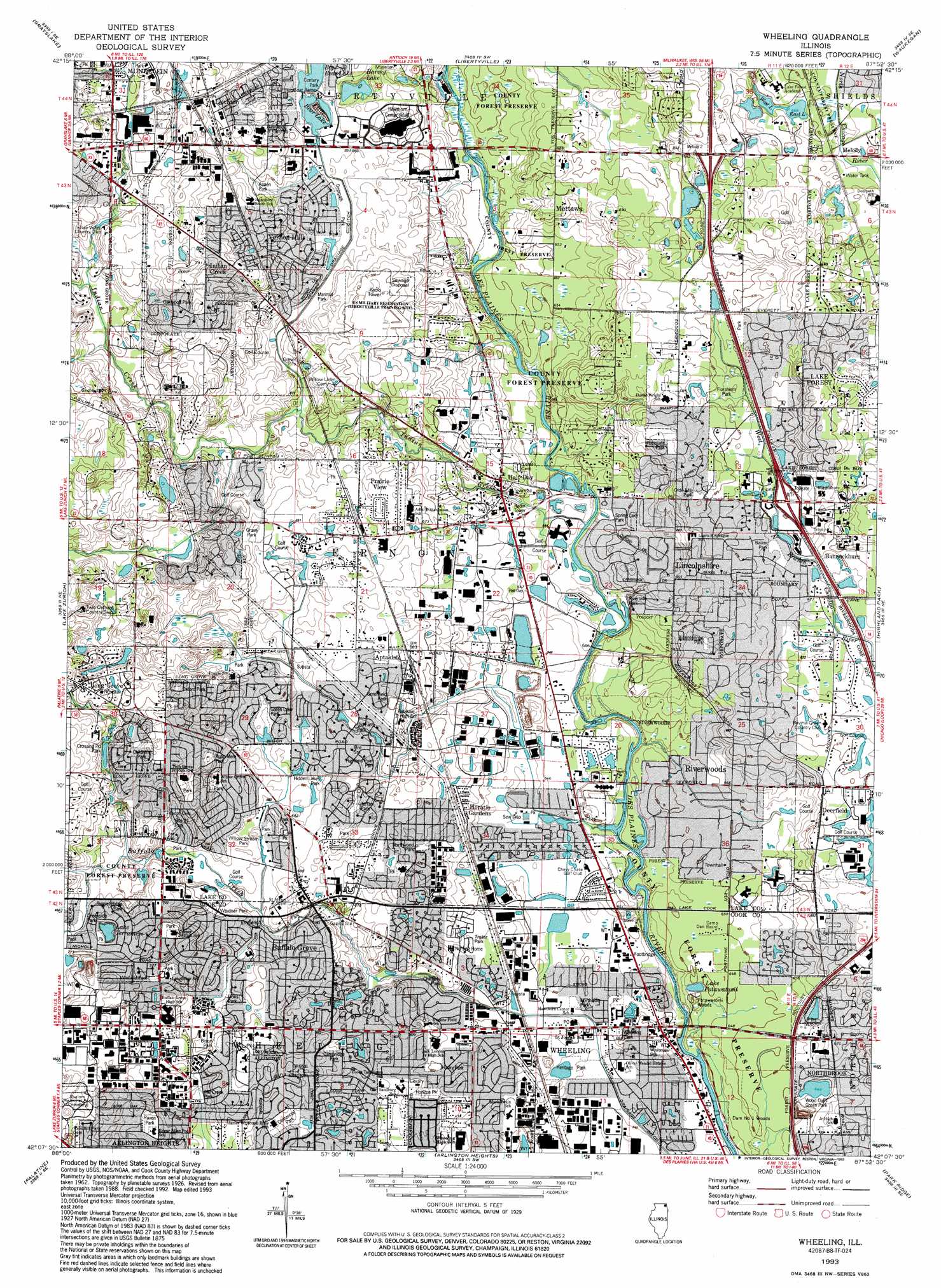
Wheeling Topo Map Illinois
To zoom in, hover over the map of Wheeling
USGS Topo Quad 42087b8 - 1:24,000 scale
| Topo Map Name: | Wheeling |
| USGS Topo Quad ID: | 42087b8 |
| Print Size: | ca. 21 1/4" wide x 27" high |
| Southeast Coordinates: | 42.125° N latitude / 87.875° W longitude |
| Map Center Coordinates: | 42.1875° N latitude / 87.9375° W longitude |
| U.S. State: | IL |
| Filename: | o42087b8.jpg |
| Download Map JPG Image: | Wheeling topo map 1:24,000 scale |
| Map Type: | Topographic |
| Topo Series: | 7.5´ |
| Map Scale: | 1:24,000 |
| Source of Map Images: | United States Geological Survey (USGS) |
| Alternate Map Versions: |
Wheeling IL 1928 Download PDF Buy paper map Wheeling IL 1928, updated 1932 Download PDF Buy paper map Wheeling IL 1928, updated 1948 Download PDF Buy paper map Wheeling IL 1953, updated 1955 Download PDF Buy paper map Wheeling IL 1963, updated 1964 Download PDF Buy paper map Wheeling IL 1963, updated 1973 Download PDF Buy paper map Wheeling IL 1963, updated 1981 Download PDF Buy paper map Wheeling IL 1963, updated 1986 Download PDF Buy paper map Wheeling IL 1993, updated 1993 Download PDF Buy paper map Wheeling IL 1998, updated 2002 Download PDF Buy paper map Wheeling IL 2012 Download PDF Buy paper map Wheeling IL 2015 Download PDF Buy paper map |
1:24,000 Topo Quads surrounding Wheeling
Fox Lake |
Antioch |
Wadsworth |
Zion |
|
Wauconda |
Grayslake |
Libertyville |
Waukegan |
|
Barrington |
Lake Zurich |
Wheeling |
Highland Park |
|
Streamwood |
Palatine |
Arlington Heights |
Park Ridge |
Evanston |
West Chicago |
Lombard |
Elmhurst |
River Forest |
Chicago Loop |
> Back to 42087a1 at 1:100,000 scale
> Back to 42086a1 at 1:250,000 scale
> Back to U.S. Topo Maps home
Wheeling topo map: Gazetteer
Wheeling: Airports
Chicagoland Airport (historical) elevation 202m 662′Wheeling: Canals
Seavey Drainage Ditch elevation 206m 675′Wheeling Drainage Ditch elevation 194m 636′
Wheeling: Dams
White Pine Ditch Reservoir Dam elevation 206m 675′Wheeling: Lakes
Big Bear Lake elevation 208m 682′Harvey Lake elevation 205m 672′
Lake Potawatomi elevation 196m 643′
Little Bear Lake elevation 209m 685′
West Lake elevation 204m 669′
Wheeling: Parks
Aspen Park elevation 211m 692′Augusta Park elevation 212m 695′
Balzer Park elevation 203m 666′
Bicentennial Park elevation 207m 679′
Bison Park elevation 215m 705′
Buffalo Creek Forest Preserve elevation 218m 715′
Busch Grove Community Park elevation 207m 679′
Cambridge Park elevation 207m 679′
Captain Dan Wright Forest Preserve elevation 197m 646′
Centennial Park elevation 210m 688′
Childerly Park elevation 203m 666′
Childrens Park elevation 218m 715′
Churchill Park elevation 207m 679′
Creekside Park elevation 215m 705′
Crossing Pond Park elevation 217m 711′
Deerpath Park elevation 206m 675′
E L Ryerson Conservation Area elevation 197m 646′
Edward L Ryerson Nature Preserve elevation 198m 649′
Emmerich East Park elevation 205m 672′
Emmerich Park elevation 209m 685′
Florsheim Park elevation 204m 669′
Florsheim Park Nature Preserve elevation 204m 669′
Grainger Woods County Forest Preserve elevation 202m 662′
Green Lake Park elevation 207m 679′
Greenfield Park elevation 208m 682′
Grove Park elevation 210m 688′
Half Day County Forest Preserve elevation 197m 646′
Heritage Park elevation 195m 639′
Hidden Lakes Park elevation 207m 679′
Highland Point Park elevation 204m 669′
Horizon Park elevation 202m 662′
Husky Park elevation 198m 649′
Lake Terramere Park elevation 217m 711′
Lions Park elevation 208m 682′
Marimal Park elevation 206m 675′
Mill Creek Park elevation 210m 688′
Nickol Knoll Park elevation 225m 738′
Northside Park elevation 198m 649′
Northwood Park elevation 203m 666′
Oakwood Park elevation 224m 734′
Old Farm Park elevation 206m 675′
Olde Mill Park elevation 208m 682′
Oxford Park elevation 219m 718′
Prairie Park elevation 206m 675′
Prairie View Park elevation 208m 682′
Raven Park elevation 217m 711′
Riverside Park elevation 193m 633′
Rupp Material Park elevation 218m 715′
Salceda Park elevation 202m 662′
Site 21 Park elevation 211m 692′
Spring Lake Park elevation 196m 643′
Sunset Ridge Park elevation 213m 698′
Tartan Park elevation 210m 688′
Twin Creeks Park elevation 206m 675′
Twin Groves Park elevation 216m 708′
Weidner Park elevation 209m 685′
Whitegate Park elevation 211m 692′
Willow Stream Park elevation 207m 679′
Winfield Park elevation 219m 718′
Wood Oaks Green Park elevation 198m 649′
Wheeling: Populated Places
Aptakisic elevation 208m 682′Avanti Ridge elevation 200m 656′
Buffalo Grove elevation 207m 679′
C H Taylor's Sanwaldrun Estates elevation 203m 666′
Charlemagne elevation 206m 675′
Dana Court Subdivision elevation 202m 662′
Downing Street Subdivision elevation 203m 666′
Edgewood Grove elevation 201m 659′
Forest View Estates elevation 198m 649′
Fournins Subdivision elevation 203m 666′
Half Day elevation 199m 652′
Horatio Gardens elevation 203m 666′
Indian Creek elevation 226m 741′
Ivy Club of Northbrook elevation 205m 672′
Lakeshire elevation 200m 656′
Leithton elevation 221m 725′
Lincolnshire elevation 201m 659′
Long Grove elevation 223m 731′
Melody elevation 204m 669′
Mettawa elevation 208m 682′
Normandy Hill elevation 205m 672′
North Northfield elevation 204m 669′
Picardy Circle elevation 200m 656′
Prairie View elevation 212m 695′
Regency Place elevation 201m 659′
Ridgeland elevation 201m 659′
Riverwoods elevation 200m 656′
Salceca North elevation 204m 669′
Sanders Crossing elevation 209m 685′
Sanders Estates elevation 207m 679′
Sanders Prairie elevation 200m 656′
Sunny Acres elevation 208m 682′
Sunset View Estates elevation 207m 679′
Sutton Point elevation 203m 666′
Vernon Hills elevation 224m 734′
Villas North elevation 200m 656′
Wheeling elevation 198m 649′
Winschester Lane North elevation 201m 659′
Wood Oaks Glen elevation 198m 649′
Woodoaks Court elevation 201m 659′
Wheeling: Post Offices
Lincolnshire Post Office elevation 202m 662′Wheeling Post Office elevation 197m 646′
Wheeling: Reservoirs
Lake Shermerville elevation 197m 646′Lake Terramere elevation 214m 702′
White Pine Ditch Reservoir elevation 206m 675′
Wheeling: Streams
Indian Creek elevation 194m 636′Wheeling: Woods
Dam Number 1 Woods elevation 197m 646′Potawatomi Woods elevation 196m 643′
Sullivan Woods elevation 209m 685′
Wheeling digital topo map on disk
Buy this Wheeling topo map showing relief, roads, GPS coordinates and other geographical features, as a high-resolution digital map file on DVD:
Northern Illinois, Northern Indiana & Southwestern Michigan
Buy digital topo maps: Northern Illinois, Northern Indiana & Southwestern Michigan