Palatine Topo Map Illinois
To zoom in, hover over the map of Palatine
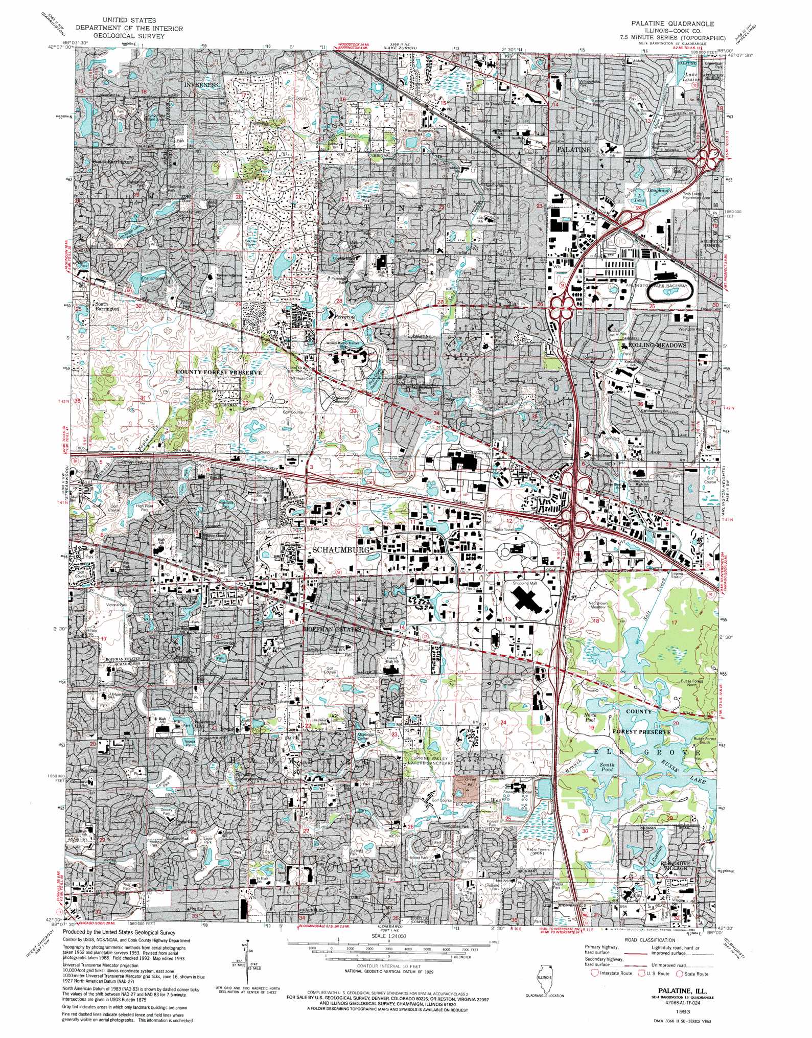
USGS Topo Quad 42088a1 - 1:24,000 scale
| Topo Map Name: | Palatine |
| USGS Topo Quad ID: | 42088a1 |
| Print Size: | ca. 21 1/4" wide x 27" high |
| Southeast Coordinates: | 42° N latitude / 88° W longitude |
| Map Center Coordinates: | 42.0625° N latitude / 88.0625° W longitude |
| U.S. State: | IL |
| Filename: | o42088a1.jpg |
| Download Map JPG Image: | Palatine topo map 1:24,000 scale |
| Map Type: | Topographic |
| Topo Series: | 7.5´ |
| Map Scale: | 1:24,000 |
| Source of Map Images: | United States Geological Survey (USGS) |
| Alternate Map Versions: |
Palatine IL 1953, updated 1955 Download PDF Buy paper map Palatine IL 1961, updated 1962 Download PDF Buy paper map Palatine IL 1961, updated 1973 Download PDF Buy paper map Palatine IL 1961, updated 1981 Download PDF Buy paper map Palatine IL 1961, updated 1987 Download PDF Buy paper map Palatine IL 1993, updated 1994 Download PDF Buy paper map Palatine IL 1998, updated 2002 Download PDF Buy paper map Palatine IL 2012 Download PDF Buy paper map Palatine IL 2015 Download PDF Buy paper map |
1:24,000 Topo Quads surrounding Palatine
Mchenry |
Wauconda |
Grayslake |
Libertyville |
Waukegan |
Crystal Lake |
Barrington |
Lake Zurich |
Wheeling |
Highland Park |
Elgin |
Streamwood |
Palatine |
Arlington Heights |
Park Ridge |
Geneva |
West Chicago |
Lombard |
Elmhurst |
River Forest |
Aurora North |
Naperville |
Wheaton |
Hinsdale |
Berwyn |
> Back to 42088a1 at 1:100,000 scale
> Back to 42088a1 at 1:250,000 scale
> Back to U.S. Topo Maps home
Palatine topo map: Gazetteer
Palatine: Airports
Gould Center Heliport elevation 213m 698′Hospital Heliport elevation 213m 698′
Marriott Heliport elevation 220m 721′
Schaumburg Municipal Helistop elevation 222m 728′
Steel Supply Heliport elevation 214m 702′
Palatine: Crossings
Interchange 1 elevation 222m 728′Interchange 4 elevation 218m 715′
Palatine: Dams
South Dam on Salt Creek elevation 210m 688′Palatine: Flats
Ned Brown Meadow elevation 214m 702′Palatine: Forests
Busse Forest North elevation 213m 698′Busse Forest South elevation 212m 695′
Palatine: Lakes
Busse Lake elevation 209m 685′Doughnut Lake elevation 216m 708′
Lake Irene elevation 216m 708′
Palatine: Parks
Abrahamsen Park elevation 229m 751′Apollo Park elevation 233m 764′
Ash Park elevation 244m 800′
Ashwood Park elevation 228m 748′
Atcher Park elevation 245m 803′
Birch Park elevation 230m 754′
Birchwood Park elevation 226m 741′
Blackhawk Park elevation 247m 810′
Bock Park elevation 249m 816′
Bond Park elevation 253m 830′
Busse Forest Nature Preserve elevation 212m 695′
Campanelli Park elevation 246m 807′
Cedar Park elevation 227m 744′
Charlemagne Park elevation 248m 813′
Chestnut Lake Park elevation 244m 800′
Chestnut Park elevation 219m 718′
Chino Park elevation 243m 797′
Clark Park elevation 223m 731′
Colony Lake Park elevation 249m 816′
Colony Park elevation 259m 849′
Colony Point Nature Area elevation 258m 846′
Community Park elevation 229m 751′
Cottonwood Park elevation 240m 787′
Cottonwood Park elevation 225m 738′
Countryside Park elevation 225m 738′
Cove Park elevation 243m 797′
Debra Park elevation 216m 708′
Disney Park elevation 213m 698′
Dooley Park elevation 245m 803′
Duxbury Park elevation 242m 793′
Eagle Park elevation 243m 797′
Evergreen Park elevation 243m 797′
Fairview Park elevation 235m 770′
Falk Park elevation 244m 800′
Fountain Square Park elevation 222m 728′
Freedom Park elevation 242m 793′
Greenbrier Park elevation 221m 725′
Hampshire Park elevation 219m 718′
Hawthorne Park elevation 223m 731′
Heron Park elevation 234m 767′
High Point Park elevation 237m 777′
Highland Park elevation 236m 774′
Hilltop Park elevation 247m 810′
Hoffman Park elevation 244m 800′
Hoover Park elevation 249m 816′
Huntington Park elevation 266m 872′
Jay Cee Park elevation 244m 800′
Juniper Park elevation 253m 830′
Kimball Hill Park elevation 215m 705′
Kingsport East Park elevation 227m 744′
Kingston Park elevation 262m 859′
Lancer Creek Park elevation 229m 751′
Levitt Park elevation 243m 797′
Lindberg Park elevation 220m 721′
Lindberg Park elevation 219m 718′
Locust Park elevation 221m 725′
Locust Park elevation 230m 754′
Maggie Rogers Park elevation 255m 836′
Mallard Park elevation 234m 767′
Maple Park elevation 242m 793′
Maple Park elevation 219m 718′
Marsh Park elevation 221m 725′
McGee Park elevation 222m 728′
Mead Park elevation 219m 718′
Ned Brown Preserve elevation 212m 695′
New Brittany Park elevation 253m 830′
North Park elevation 248m 813′
North Ridge Lake Park elevation 253m 830′
Oak Hollow Conservation Area elevation 247m 810′
Oak Park elevation 219m 718′
Palatine Prairie Nature Preserve elevation 234m 767′
Patomic Park elevation 224m 734′
Patridge Park elevation 231m 757′
Paul Douglas Forest Preserve elevation 245m 803′
Peregrine Park elevation 228m 748′
Pine Park elevation 251m 823′
Plum Grove Reservoir Park elevation 229m 751′
Pochet Park elevation 247m 810′
Powell Park elevation 216m 708′
Riemer Reservoir Park elevation 235m 770′
Roberts Park elevation 248m 813′
Salk Park elevation 252m 826′
Salk Park elevation 213m 698′
Sheffield Park elevation 250m 820′
Slingerland Park elevation 247m 810′
Sloan Park elevation 247m 810′
South Park elevation 248m 813′
South Ridge Lake Park elevation 252m 826′
Sparrow Park elevation 234m 767′
Spring Valley Nature Sanctuary elevation 219m 718′
Summit Park elevation 233m 764′
Sundance Park elevation 255m 836′
Sunset Meadows Park elevation 208m 682′
Sunset Park elevation 230m 754′
Terada Park elevation 247m 810′
Thornbark Park elevation 252m 826′
Timbercrest Park elevation 241m 790′
Twin Lakes Recreational Area elevation 216m 708′
Valley Park elevation 247m 810′
Victoria Park elevation 242m 793′
Virginia Terrace Park elevation 223m 731′
Vogelei Park elevation 252m 826′
Volkening Park elevation 246m 807′
Waverly Park elevation 213m 698′
Westbury Lake Park elevation 248m 813′
Westgate Park elevation 217m 711′
Whippoorwill Park elevation 235m 770′
Whispering Lake Park elevation 258m 846′
Willow Park elevation 252m 826′
Willowwood Park elevation 224m 734′
Winston Park elevation 221m 725′
Woodland Meadows Park elevation 216m 708′
Woodstock Park elevation 247m 810′
Zocher Park elevation 252m 826′
Palatine: Populated Places
Creekside elevation 222m 728′Fairfax Village elevation 225m 738′
Hoffman Estates elevation 239m 784′
Inverness elevation 257m 843′
Palatine elevation 226m 741′
Plum Grove Village elevation 226m 741′
Rolling Meadows elevation 219m 718′
Schaumburg elevation 242m 793′
South Barrington elevation 259m 849′
Williamsburg elevation 214m 702′
Winthrop Village elevation 225m 738′
Palatine: Post Offices
Palatine Post Office elevation 230m 754′Schaumburg Post Office elevation 247m 810′
Palatine: Reservoirs
Busse Woods Reservoir elevation 210m 688′Kingsport Lake elevation 234m 767′
Lake Cosman elevation 212m 695′
North Pool elevation 210m 688′
Peregrine Lake elevation 227m 744′
South Pool elevation 209m 685′
Volkening Lake elevation 245m 803′
Palatine: Streams
West Branch Salt Creek elevation 209m 685′Palatine digital topo map on disk
Buy this Palatine topo map showing relief, roads, GPS coordinates and other geographical features, as a high-resolution digital map file on DVD:
Northern Illinois, Northern Indiana & Southwestern Michigan
Buy digital topo maps: Northern Illinois, Northern Indiana & Southwestern Michigan