Caledonia Topo Map Illinois
To zoom in, hover over the map of Caledonia
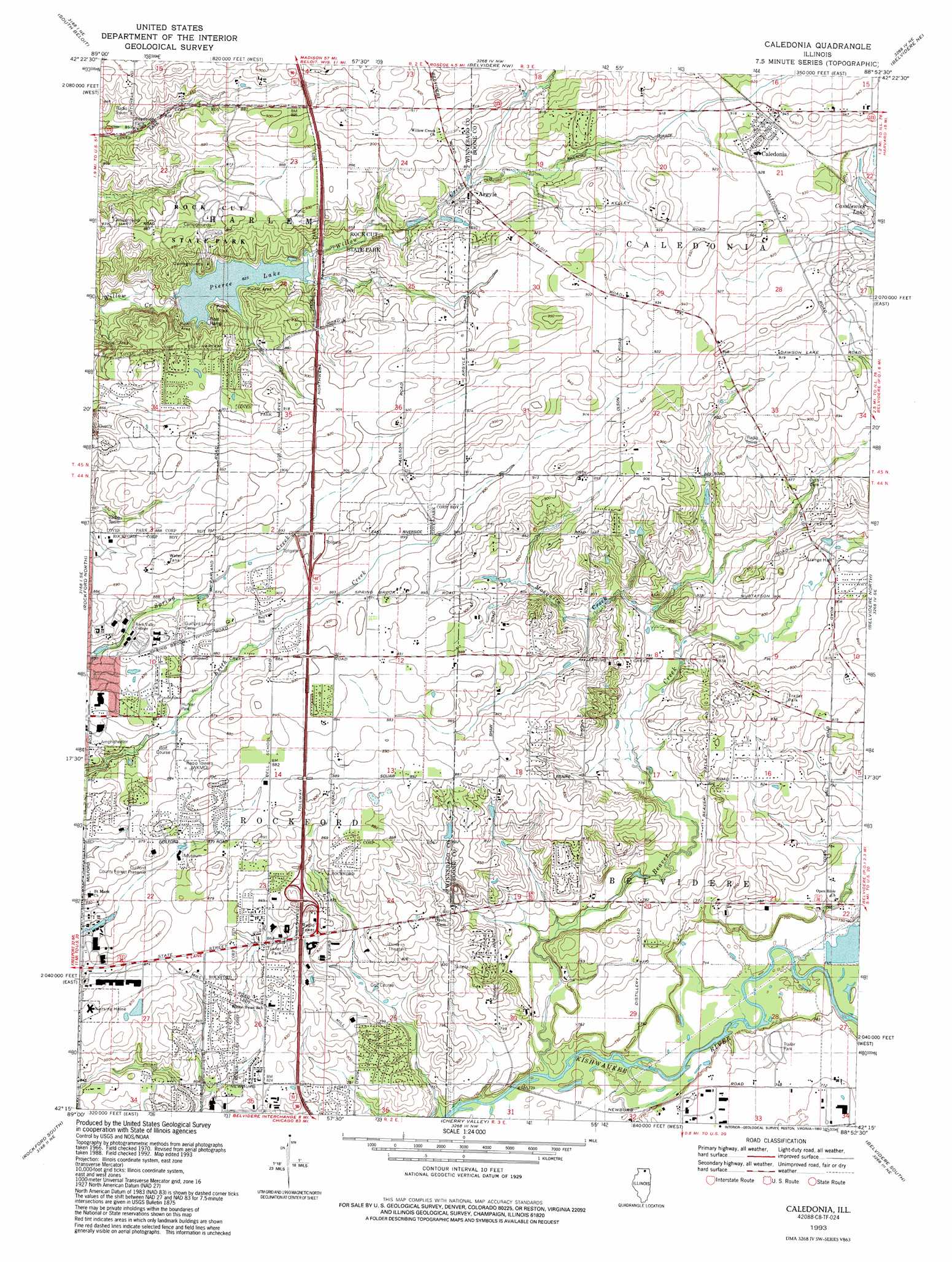
USGS Topo Quad 42088c8 - 1:24,000 scale
| Topo Map Name: | Caledonia |
| USGS Topo Quad ID: | 42088c8 |
| Print Size: | ca. 21 1/4" wide x 27" high |
| Southeast Coordinates: | 42.25° N latitude / 88.875° W longitude |
| Map Center Coordinates: | 42.3125° N latitude / 88.9375° W longitude |
| U.S. State: | IL |
| Filename: | o42088c8.jpg |
| Download Map JPG Image: | Caledonia topo map 1:24,000 scale |
| Map Type: | Topographic |
| Topo Series: | 7.5´ |
| Map Scale: | 1:24,000 |
| Source of Map Images: | United States Geological Survey (USGS) |
| Alternate Map Versions: |
Caledonia IL 1970, updated 1972 Download PDF Buy paper map Caledonia IL 1970, updated 1977 Download PDF Buy paper map Caledonia IL 2012 Download PDF Buy paper map Caledonia IL 2015 Download PDF Buy paper map |
1:24,000 Topo Quads surrounding Caledonia
Newark |
Beloit |
Shopiere |
Clinton |
Sharon |
Shirland |
South Beloit |
Belvidere Nw |
Belvidere Ne |
Capron |
Winnebago |
Rockford North |
Caledonia |
Belvidere North |
Garden Prairie |
Kishwaukee |
Rockford South |
Cherry Valley |
Belvidere South |
Riley |
Stillman Valley |
Kings |
Fairdale |
Kirkland |
Genoa |
> Back to 42088a1 at 1:100,000 scale
> Back to 42088a1 at 1:250,000 scale
> Back to U.S. Topo Maps home
Caledonia topo map: Gazetteer
Caledonia: Airports
Kings Acres Airport elevation 271m 889′Caledonia: Dams
Pierce Lake Dam elevation 254m 833′Caledonia: Forests
Willow Creek Forest Preserve (historical) elevation 245m 803′Caledonia: Mines
State Street Mine elevation 241m 790′Caledonia: Parks
Guilford County Forest Preserve elevation 262m 859′Hunter Park elevation 261m 856′
Plum Grove Nature Preserve elevation 265m 869′
Rock Cut State Park elevation 254m 833′
Caledonia: Populated Places
Argyle elevation 269m 882′Caledonia elevation 283m 928′
North Caledonia (historical) elevation 284m 931′
Caledonia: Post Offices
Caledonia Post Office elevation 283m 928′Caledonia: Reservoirs
Pierce Lake elevation 251m 823′Caledonia: Streams
Beaver Creek elevation 222m 728′Meander Creek elevation 237m 777′
Caledonia digital topo map on disk
Buy this Caledonia topo map showing relief, roads, GPS coordinates and other geographical features, as a high-resolution digital map file on DVD:
Northern Illinois, Northern Indiana & Southwestern Michigan
Buy digital topo maps: Northern Illinois, Northern Indiana & Southwestern Michigan