Antioch Topo Map Illinois
To zoom in, hover over the map of Antioch
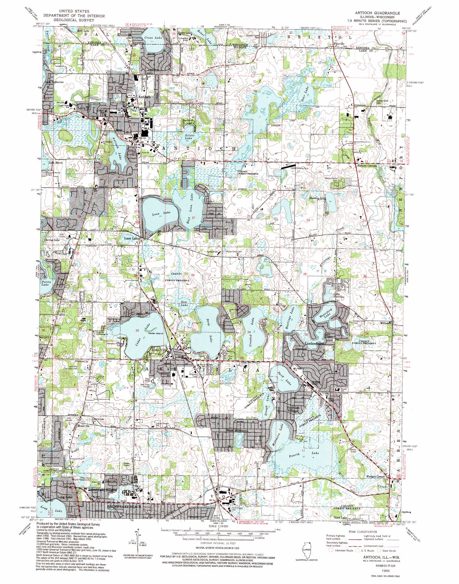
USGS Topo Quad 42088d1 - 1:24,000 scale
| Topo Map Name: | Antioch |
| USGS Topo Quad ID: | 42088d1 |
| Print Size: | ca. 21 1/4" wide x 27" high |
| Southeast Coordinates: | 42.375° N latitude / 88° W longitude |
| Map Center Coordinates: | 42.4375° N latitude / 88.0625° W longitude |
| U.S. States: | IL, WI |
| Filename: | o42088d1.jpg |
| Download Map JPG Image: | Antioch topo map 1:24,000 scale |
| Map Type: | Topographic |
| Topo Series: | 7.5´ |
| Map Scale: | 1:24,000 |
| Source of Map Images: | United States Geological Survey (USGS) |
| Alternate Map Versions: |
Antioch IL 1960, updated 1962 Download PDF Buy paper map Antioch IL 1960, updated 1973 Download PDF Buy paper map Antioch IL 1960, updated 1986 Download PDF Buy paper map Antioch IL 1993, updated 1993 Download PDF Buy paper map Antioch IL 2012 Download PDF Buy paper map Antioch IL 2015 Download PDF Buy paper map |
1:24,000 Topo Quads surrounding Antioch
Burlington |
Rochester |
Union Grove |
Sturtevant |
Racine South |
Genoa City |
Silver Lake |
Paddock Lake |
Pleasant Prairie |
Kenosha |
Richmond |
Fox Lake |
Antioch |
Wadsworth |
Zion |
Mchenry |
Wauconda |
Grayslake |
Libertyville |
Waukegan |
Crystal Lake |
Barrington |
Lake Zurich |
Wheeling |
Highland Park |
> Back to 42088a1 at 1:100,000 scale
> Back to 42088a1 at 1:250,000 scale
> Back to U.S. Topo Maps home
Antioch topo map: Gazetteer
Antioch: Airports
Donald Alfred Gade Airport elevation 244m 800′Antioch: Canals
Dutch Gap Canal elevation 229m 751′Antioch: Dams
Elmwood Farms Lake Dam elevation 223m 731′Lake Linden Dam elevation 235m 770′
White Lake Dam elevation 240m 787′
Antioch: Islands
Cedar Island elevation 241m 790′Antioch: Lakes
Antioch Lake elevation 229m 751′Benet Lake elevation 241m 790′
Benet Lake elevation 241m 790′
Cedar Lake elevation 238m 780′
Crooked Lake elevation 232m 761′
Cross Lake elevation 247m 810′
Cross Lake elevation 247m 810′
Deep Lake elevation 235m 770′
Deer Lake elevation 232m 761′
East Loon Lake elevation 235m 770′
Faith Evangelical Lutheran School elevation 239m 784′
Fourth Lake elevation 232m 761′
Hastings Lake elevation 232m 761′
Hendrick Lake elevation 241m 790′
Huntley Lake elevation 229m 751′
Lake Potomac elevation 232m 761′
Loon Lake elevation 235m 770′
Miltmore Lake elevation 232m 761′
Redwing Slough Lake elevation 235m 770′
Sand Lake elevation 235m 770′
Silver Lake elevation 232m 761′
Slough Lake elevation 235m 770′
Sun Lake elevation 235m 770′
Waterford Lake elevation 232m 761′
Antioch: Parks
Cedar Lake Bog Nature Preserve elevation 242m 793′Duck Hill Farm Forest Preserve elevation 237m 777′
East End Park elevation 245m 803′
Engle Memorial Park elevation 237m 777′
Forest View Park elevation 235m 770′
Fourth Lake Fen Forest Preserve elevation 234m 767′
Gateway Park elevation 237m 777′
Lake Villa Park elevation 244m 800′
Lake Villa Township Park elevation 245m 803′
McDonald Woods Forest Preserve elevation 222m 728′
Redwing Slough Forest Preserve elevation 236m 774′
Shag Lake Nature Preserve Park elevation 235m 770′
Sun Lake Forest Preserve elevation 236m 774′
Willow Park elevation 234m 767′
Antioch: Populated Places
Antioch elevation 239m 784′Benet Lake elevation 262m 859′
Hickory Corners elevation 242m 793′
Lake Villa elevation 241m 790′
Lindenhurst elevation 243m 797′
Loon Lake elevation 238m 780′
Millburn elevation 226m 741′
Monaville elevation 241m 790′
Pikeville elevation 237m 777′
Rainbow Lake Manor Mobile Home Park elevation 241m 790′
Rollins elevation 241m 790′
Round Lake Heights elevation 239m 784′
Venetian Village elevation 243m 797′
Wedges Corner elevation 236m 774′
Antioch: Post Offices
Sand Lake Post Office (historical) elevation 240m 787′Antioch: Reservoirs
Elmwood Farms Lake elevation 223m 731′Homer White Lake elevation 238m 780′
Lake Linden elevation 235m 770′
White Lake elevation 240m 787′
Antioch: Streams
Eagle Creek elevation 226m 741′Hastings Creek elevation 222m 728′
Sequoit Creek elevation 226m 741′
Trevor Creek elevation 225m 738′
Trevor Creek elevation 225m 738′
Antioch digital topo map on disk
Buy this Antioch topo map showing relief, roads, GPS coordinates and other geographical features, as a high-resolution digital map file on DVD:
Northern Illinois, Northern Indiana & Southwestern Michigan
Buy digital topo maps: Northern Illinois, Northern Indiana & Southwestern Michigan