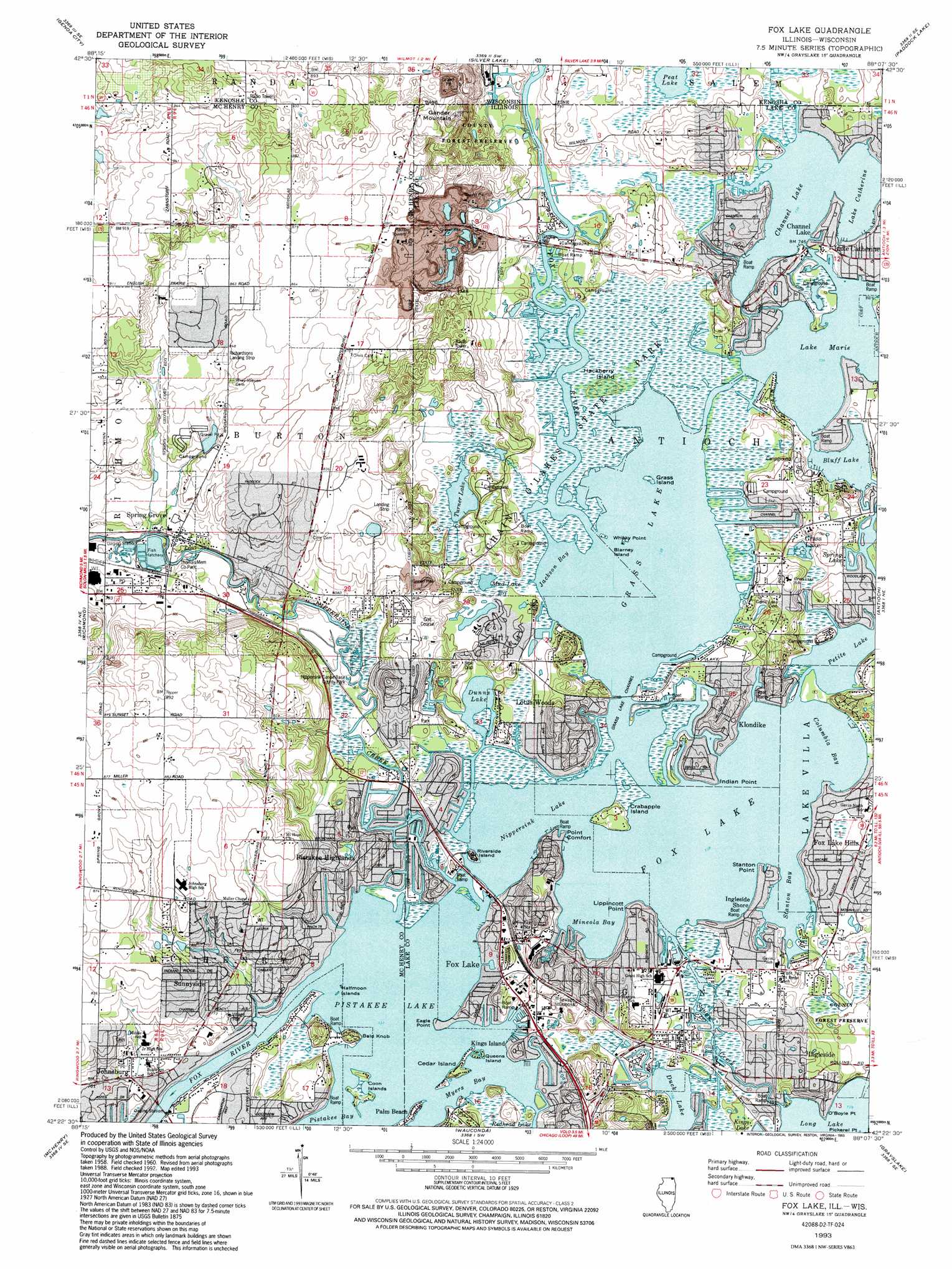
Fox Lake Topo Map Illinois
To zoom in, hover over the map of Fox Lake
USGS Topo Quad 42088d2 - 1:24,000 scale
| Topo Map Name: | Fox Lake |
| USGS Topo Quad ID: | 42088d2 |
| Print Size: | ca. 21 1/4" wide x 27" high |
| Southeast Coordinates: | 42.375° N latitude / 88.125° W longitude |
| Map Center Coordinates: | 42.4375° N latitude / 88.1875° W longitude |
| U.S. States: | IL, WI |
| Filename: | o42088d2.jpg |
| Download Map JPG Image: | Fox Lake topo map 1:24,000 scale |
| Map Type: | Topographic |
| Topo Series: | 7.5´ |
| Map Scale: | 1:24,000 |
| Source of Map Images: | United States Geological Survey (USGS) |
| Alternate Map Versions: |
Fox Lake IL 1960, updated 1962 Download PDF Buy paper map Fox Lake IL 1960, updated 1973 Download PDF Buy paper map Fox Lake IL 1960, updated 1983 Download PDF Buy paper map Fox Lake IL 1993, updated 1993 Download PDF Buy paper map Fox Lake IL 2012 Download PDF Buy paper map Fox Lake IL 2015 Download PDF Buy paper map |
1:24,000 Topo Quads surrounding Fox Lake
Springfield |
Burlington |
Rochester |
Union Grove |
Sturtevant |
Lake Geneva |
Genoa City |
Silver Lake |
Paddock Lake |
Pleasant Prairie |
Hebron |
Richmond |
Fox Lake |
Antioch |
Wadsworth |
Woodstock |
Mchenry |
Wauconda |
Grayslake |
Libertyville |
Huntley |
Crystal Lake |
Barrington |
Lake Zurich |
Wheeling |
> Back to 42088a1 at 1:100,000 scale
> Back to 42088a1 at 1:250,000 scale
> Back to U.S. Topo Maps home
Fox Lake topo map: Gazetteer
Fox Lake: Airports
Antioch Airport (historical) elevation 229m 751′Arrow Heliport elevation 225m 738′
Fox Lake Seaplane Base elevation 224m 734′
Pillow Hill Airport elevation 248m 813′
Precision Chrome Heliport elevation 225m 738′
Richardson Field elevation 258m 846′
Richardsons Landing Strip elevation 259m 849′
Fox Lake: Bays
Columbia Bay elevation 223m 731′Jackson Bay elevation 223m 731′
Mineola Bay elevation 223m 731′
Stanton Bay elevation 223m 731′
Fox Lake: Capes
Eagle Point elevation 223m 731′Indian Point elevation 226m 741′
Lippincott Point elevation 229m 751′
Lotus Point elevation 227m 744′
O'Boyle Point elevation 224m 734′
Pickerel Point elevation 224m 734′
Point Comfort elevation 223m 731′
Stanton Point elevation 223m 731′
Whisky Point elevation 223m 731′
Fox Lake: Dams
Eagle Lake 3WR1658 Dam elevation 228m 748′Kazimier Lake Dam elevation 242m 793′
Fox Lake: Islands
Barney Island elevation 223m 731′Cedar Island elevation 226m 741′
Coon Islands elevation 223m 731′
Crabapple Island elevation 225m 738′
Grass Island elevation 223m 731′
Hackberry Island elevation 227m 744′
Halfmoon Islands elevation 223m 731′
Queens Island elevation 224m 734′
Riverside Island elevation 229m 751′
Fox Lake: Lakes
Bluff Lake elevation 223m 731′Channel Lake elevation 223m 731′
Duck Lake elevation 223m 731′
Dunns Lake elevation 223m 731′
Fox Lake elevation 223m 731′
Grass Lake elevation 223m 731′
Lake Catherine elevation 223m 731′
Lake Marie elevation 223m 731′
Long Lake elevation 224m 734′
Mud Lake elevation 225m 738′
Nippersink Lake elevation 223m 731′
Peat Lake elevation 226m 741′
Petite Lake elevation 223m 731′
Pistakee Lake elevation 223m 731′
Spring Lake elevation 223m 731′
Turner Lake elevation 226m 741′
Fox Lake: Parks
Chain O'Lakes State Park elevation 225m 738′Gander Mountain Forest Preserve elevation 237m 777′
Gavin Bog and Prairie Nature Preserve elevation 229m 751′
Grant Woods Forest Preserve elevation 229m 751′
Nippersink Canoe Base County Park elevation 226m 741′
Peat Lake State Natural Area elevation 226m 741′
Spring Grove Fen Nature Preserve elevation 228m 748′
Thomas Memorial County Park elevation 227m 744′
Turner Lake Fen Nature Preserve elevation 226m 741′
Weingart Road Sedge Meadow Nature Preserve elevation 224m 734′
Fox Lake: Populated Places
Channel Lake elevation 227m 744′Fox Lake elevation 228m 748′
Fox Lake Hills elevation 229m 751′
Grass Lake elevation 234m 767′
Ingleside elevation 233m 764′
Ingleside Shore elevation 226m 741′
Johnsburg elevation 229m 751′
Kings Island elevation 233m 764′
Klondike elevation 237m 777′
Lake Catherine elevation 228m 748′
Lotus Woods elevation 240m 787′
Palm Beach elevation 229m 751′
Pistakee elevation 226m 741′
Pistakee Highlands elevation 231m 757′
Spring Grove elevation 233m 764′
Sunnyside elevation 232m 761′
Fox Lake: Post Offices
English Prairie Post Office (historical) elevation 271m 889′Spring Grove Post Office elevation 241m 790′
Fox Lake: Reservoirs
Eagle Lake 7 elevation 228m 748′Kazimier Lake elevation 242m 793′
Fox Lake: Streams
Fox River elevation 223m 731′Nippersink Creek elevation 223m 731′
Squaw Creek elevation 223m 731′
Fox Lake: Summits
Bald Knob elevation 235m 770′Gander Mountain elevation 283m 928′
Fox Lake digital topo map on disk
Buy this Fox Lake topo map showing relief, roads, GPS coordinates and other geographical features, as a high-resolution digital map file on DVD:
Northern Illinois, Northern Indiana & Southwestern Michigan
Buy digital topo maps: Northern Illinois, Northern Indiana & Southwestern Michigan