Burlington Topo Map Wisconsin
To zoom in, hover over the map of Burlington
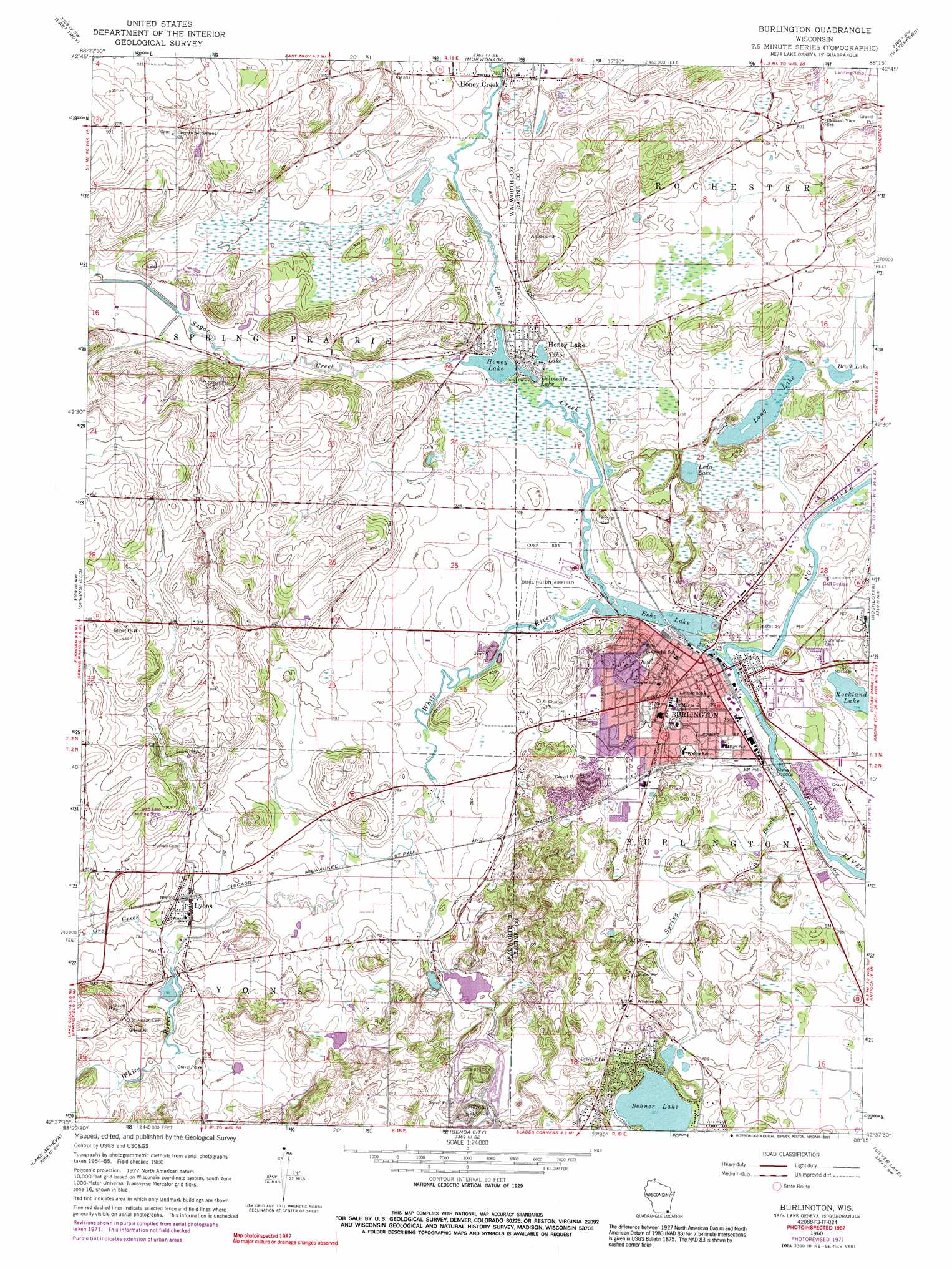
USGS Topo Quad 42088f3 - 1:24,000 scale
| Topo Map Name: | Burlington |
| USGS Topo Quad ID: | 42088f3 |
| Print Size: | ca. 21 1/4" wide x 27" high |
| Southeast Coordinates: | 42.625° N latitude / 88.25° W longitude |
| Map Center Coordinates: | 42.6875° N latitude / 88.3125° W longitude |
| U.S. State: | WI |
| Filename: | o42088f3.jpg |
| Download Map JPG Image: | Burlington topo map 1:24,000 scale |
| Map Type: | Topographic |
| Topo Series: | 7.5´ |
| Map Scale: | 1:24,000 |
| Source of Map Images: | United States Geological Survey (USGS) |
| Alternate Map Versions: |
Burlington WI 1960, updated 1962 Download PDF Buy paper map Burlington WI 1960, updated 1973 Download PDF Buy paper map Burlington WI 1960, updated 1991 Download PDF Buy paper map Burlington WI 2010 Download PDF Buy paper map Burlington WI 2013 Download PDF Buy paper map Burlington WI 2016 Download PDF Buy paper map |
1:24,000 Topo Quads surrounding Burlington
Palmyra |
Eagle |
Genesee |
Muskego |
Hales Corners |
Little Prairie |
East Troy |
Mukwonago |
Waterford |
North Cape |
Elkhorn |
Springfield |
Burlington |
Rochester |
Union Grove |
Walworth |
Lake Geneva |
Genoa City |
Silver Lake |
Paddock Lake |
Harvard |
Hebron |
Richmond |
Fox Lake |
Antioch |
> Back to 42088e1 at 1:100,000 scale
> Back to 42088a1 at 1:250,000 scale
> Back to U.S. Topo Maps home
Burlington topo map: Gazetteer
Burlington: Airports
Burlington Municipal Airport elevation 236m 774′Wag-Aero Airport elevation 272m 892′
Burlington: Dams
Burlington 2WP311 Dam elevation 232m 761′Honey Lake WP276 Dam elevation 235m 770′
Burlington: Lakes
Bohner Lake elevation 245m 803′Brock Lake elevation 230m 754′
Leda Lake elevation 230m 754′
Long Lake elevation 230m 754′
Rockland Lake elevation 231m 757′
Tahoe Lake elevation 237m 777′
Burlington: Parks
Beaumont Field elevation 231m 757′Benson Park elevation 231m 757′
Bushnell Park elevation 232m 761′
Devor Park elevation 240m 787′
Echo Veterans Memorial Park elevation 231m 757′
Grove Street Park elevation 233m 764′
Highridge Park elevation 268m 879′
McCanna Park elevation 231m 757′
Meinhardt Park elevation 231m 757′
Nestles Park elevation 233m 764′
Riverside Park elevation 231m 757′
Schamling Park elevation 243m 797′
Steinhoff Park elevation 236m 774′
Sunset Park elevation 242m 793′
Wagner Park elevation 233m 764′
Water Tower Park elevation 249m 816′
Wehmhoff Jucker Park elevation 231m 757′
Wehmhoff Square elevation 233m 764′
Burlington: Populated Places
Burlington elevation 234m 767′Honey Creek elevation 246m 807′
Honey Lake elevation 236m 774′
Lyons elevation 244m 800′
Motors Mobile Home Park elevation 238m 780′
Burlington: Post Offices
Burlington Post Office elevation 232m 761′Burlington: Reservoirs
Delmonte Lake elevation 235m 770′Echo Lake elevation 233m 764′
Echo Lake 284 elevation 232m 761′
Honey Lake elevation 235m 770′
Honey Lake 70 elevation 235m 770′
Burlington: Streams
Honey Creek elevation 232m 761′Ore Creek elevation 237m 777′
Spring Brook elevation 229m 751′
Sugar Creek elevation 234m 767′
White River elevation 231m 757′
Burlington digital topo map on disk
Buy this Burlington topo map showing relief, roads, GPS coordinates and other geographical features, as a high-resolution digital map file on DVD:
Northern Illinois, Northern Indiana & Southwestern Michigan
Buy digital topo maps: Northern Illinois, Northern Indiana & Southwestern Michigan