Janesville East Topo Map Wisconsin
To zoom in, hover over the map of Janesville East
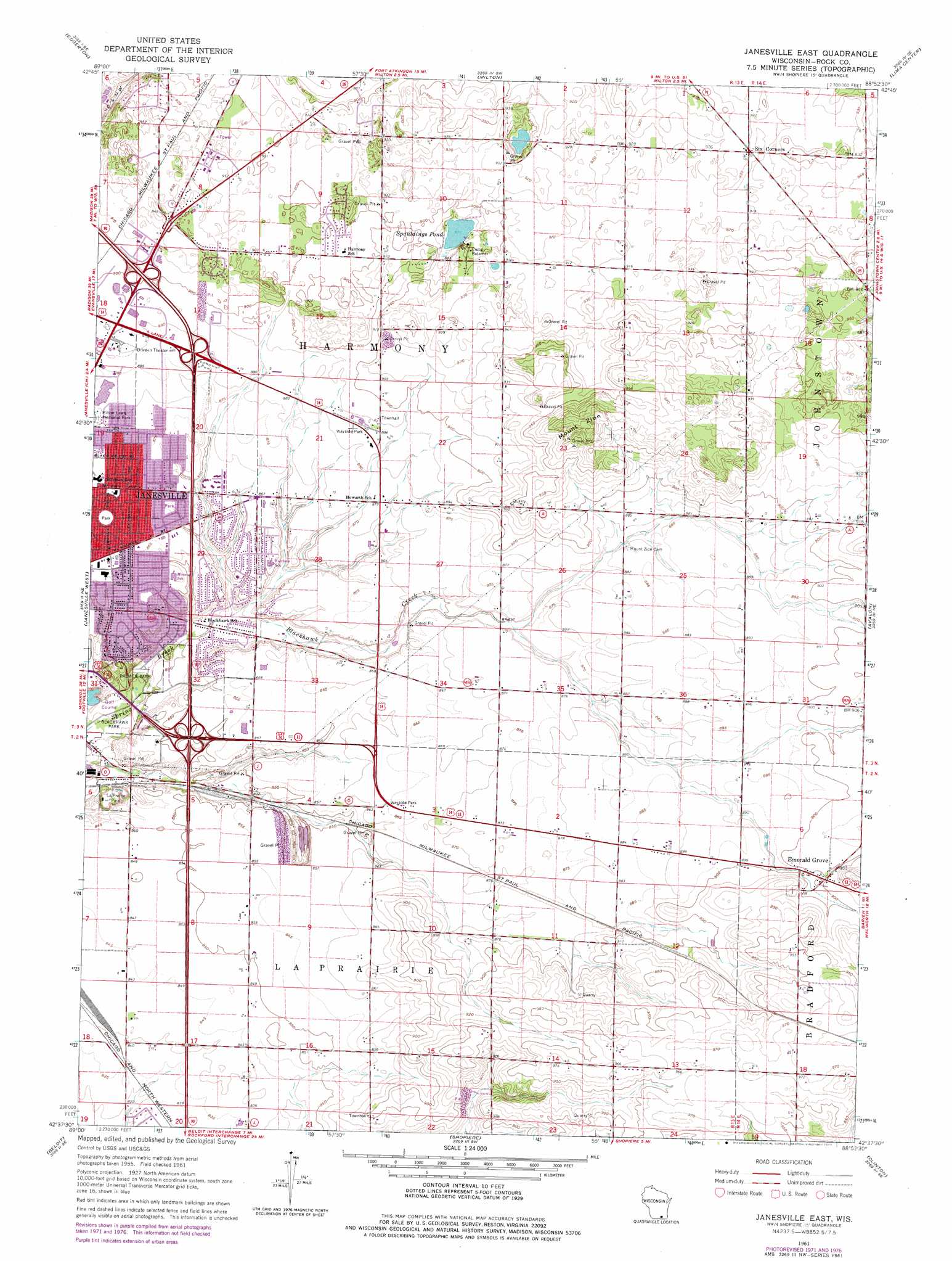
USGS Topo Quad 42088f8 - 1:24,000 scale
| Topo Map Name: | Janesville East |
| USGS Topo Quad ID: | 42088f8 |
| Print Size: | ca. 21 1/4" wide x 27" high |
| Southeast Coordinates: | 42.625° N latitude / 88.875° W longitude |
| Map Center Coordinates: | 42.6875° N latitude / 88.9375° W longitude |
| U.S. State: | WI |
| Filename: | o42088f8.jpg |
| Download Map JPG Image: | Janesville East topo map 1:24,000 scale |
| Map Type: | Topographic |
| Topo Series: | 7.5´ |
| Map Scale: | 1:24,000 |
| Source of Map Images: | United States Geological Survey (USGS) |
| Alternate Map Versions: |
Janesville East WI 1961, updated 1964 Download PDF Buy paper map Janesville East WI 1961, updated 1972 Download PDF Buy paper map Janesville East WI 1961, updated 1977 Download PDF Buy paper map Janesville East WI 2010 Download PDF Buy paper map Janesville East WI 2013 Download PDF Buy paper map Janesville East WI 2016 Download PDF Buy paper map |
1:24,000 Topo Quads surrounding Janesville East
Stoughton |
Rockdale |
Busseyville |
Fort Atkinson |
Rome |
Cooksville |
Edgerton |
Milton |
Lima Center |
Whitewater |
Footville |
Janesville West |
Janesville East |
Avalon |
Delavan |
Newark |
Beloit |
Shopiere |
Clinton |
Sharon |
Shirland |
South Beloit |
Belvidere Nw |
Belvidere Ne |
Capron |
> Back to 42088e1 at 1:100,000 scale
> Back to 42088a1 at 1:250,000 scale
> Back to U.S. Topo Maps home
Janesville East topo map: Gazetteer
Janesville East: Crossings
Exit 177 elevation 259m 849′Interchange 171 elevation 278m 912′
Interchange 175 elevation 259m 849′
Janesville East: Lakes
Spauldings Pond elevation 265m 869′Janesville East: Parks
Ardon Park elevation 269m 882′Blackhawk Meadows Park elevation 245m 803′
Blackhawk Park elevation 237m 777′
Georgetown Park elevation 266m 872′
Hampshire Park elevation 261m 856′
Hawthorne Park elevation 265m 869′
Huron Park elevation 262m 859′
Jackman Park elevation 259m 849′
LaPrairie Park elevation 236m 774′
Mandale Park elevation 262m 859′
Palmer Park elevation 241m 790′
Ruger Park elevation 261m 856′
Saturn Park elevation 274m 898′
Janesville East: Populated Places
Emerald Grove elevation 274m 898′Janesville East: Streams
Blackhawk Creek elevation 246m 807′Janesville East: Summits
Mount Zion elevation 316m 1036′Janesville East digital topo map on disk
Buy this Janesville East topo map showing relief, roads, GPS coordinates and other geographical features, as a high-resolution digital map file on DVD:
Northern Illinois, Northern Indiana & Southwestern Michigan
Buy digital topo maps: Northern Illinois, Northern Indiana & Southwestern Michigan