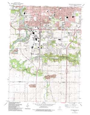
Rockford South Topo Map Illinois
To zoom in, hover over the map of Rockford South
USGS Topo Quad 42089b1 - 1:24,000 scale
| Topo Map Name: | Rockford South |
| USGS Topo Quad ID: | 42089b1 |
| Print Size: | ca. 21 1/4" wide x 27" high |
| Southeast Coordinates: | 42.125° N latitude / 89° W longitude |
| Map Center Coordinates: | 42.1875° N latitude / 89.0625° W longitude |
| U.S. State: | IL |
| Filename: | o42089b1.jpg |
| Download Map JPG Image: | Rockford South topo map 1:24,000 scale |
| Map Type: | Topographic |
| Topo Series: | 7.5´ |
| Map Scale: | 1:24,000 |
| Source of Map Images: | United States Geological Survey (USGS) |
| Alternate Map Versions: |
Camp Grant IL 1949, updated 1949 Download PDF Buy paper map Rockford South IL 1971, updated 1973 Download PDF Buy paper map Rockford South IL 1971, updated 1977 Download PDF Buy paper map Rockford South IL 1993, updated 1993 Download PDF Buy paper map Rockford South IL 2012 Download PDF Buy paper map Rockford South IL 2015 Download PDF Buy paper map |
1:24,000 Topo Quads surrounding Rockford South
> Back to 42089a1 at 1:100,000 scale
> Back to 42088a1 at 1:250,000 scale
> Back to U.S. Topo Maps home
Rockford South topo map: Gazetteer
Rockford South: Airports
Greater Rockford Airport elevation 222m 728′Rockford South: Crossings
Interchange 115 elevation 255m 836′Rockford South: Forests
Kilbuck Bluffs County Forest Preserve elevation 220m 721′Kishwaukee County Forest Preserve elevation 233m 764′
Kishwaukee Gorge North County Forest Preserve elevation 259m 849′
Kishwaukee Gorge South County Forest Preserve elevation 247m 810′
Klehm County Forest Preserve elevation 233m 764′
Rockford Rotary County Forest Preserve elevation 240m 787′
Trailside County Forest Preserve elevation 236m 774′
Rockford South: Islands
Blackhawk Island elevation 214m 702′Island Number 1 elevation 211m 692′
Rockford South: Mines
Mulford Quarry Number 139 elevation 247m 810′Rockview Quarry elevation 230m 754′
Rockford South: Parks
Atwood Park Estates Playground elevation 254m 833′Blackhawk Park elevation 227m 744′
Don Schmid Park elevation 218m 715′
GEM Field Park elevation 213m 698′
Harmon Park elevation 237m 777′
Jamestown Park elevation 225m 738′
Ken-Rock Park elevation 221m 725′
Mariposa Playground elevation 268m 879′
Pinetree Park elevation 216m 708′
Sarbrook Park elevation 222m 728′
Sawyer Playground elevation 231m 757′
Seth B Atwood Park elevation 218m 715′
Southeast Park elevation 224m 734′
Vasa Park elevation 252m 826′
Rockford South: Populated Places
Anns Mobile Home Park elevation 236m 774′Arthur L Johnson Subdivision elevation 234m 767′
Atwood Estates elevation 250m 820′
Atwood Park Estates elevation 250m 820′
Blackcrest elevation 247m 810′
Blackhawk Island Subdivision elevation 212m 695′
Blackhawk Island Subdivision Number 2 elevation 214m 702′
Burr Oak Acres elevation 255m 836′
Canyon Ridge elevation 251m 823′
Cheyenne Heights elevation 235m 770′
Clarks Mobile Home Park elevation 239m 784′
Cleveland Subdivision elevation 234m 767′
Coreys Bluff elevation 237m 777′
Coventry Hills elevation 251m 823′
Factory Addition elevation 222m 728′
Family Manufactured Home Community elevation 220m 721′
Franklin Gardens elevation 218m 715′
Fritchens Subdivision elevation 236m 774′
Gem Suburban Manufactured Housing Community elevation 215m 705′
Gottfred Subdivision elevation 222m 728′
Grant Park elevation 223m 731′
Green View Heights elevation 243m 797′
Greendale elevation 240m 787′
Greenridge Estates elevation 249m 816′
Harrison Avenue Gardens elevation 224m 734′
Harrisville elevation 238m 780′
Hickory View Estates elevation 247m 810′
Indian Village elevation 221m 725′
Kinseys Little Farms elevation 219m 718′
Kishwaukee Glen elevation 254m 833′
Kishwaukee Subdivision elevation 224m 734′
Lindberg Park elevation 239m 784′
Linview elevation 248m 813′
Lloyd Whale Subdivision elevation 240m 787′
Lonesome Acres elevation 253m 830′
Mancuso Village Park elevation 228m 748′
Maywood Manor elevation 236m 774′
Morris Kennedy Subdivision elevation 227m 744′
Morristown elevation 230m 754′
Mulford Highlands elevation 248m 813′
Mutimer Subdivision elevation 235m 770′
New Milford elevation 224m 734′
Normandy Heights elevation 236m 774′
Pine Manor elevation 248m 813′
Ravinia Park elevation 220m 721′
River Forest elevation 219m 718′
River Grove elevation 250m 820′
Riverview Mobile Home Park elevation 212m 695′
Shepardson Subdivision elevation 259m 849′
Silver Hills elevation 242m 793′
Victory Homes elevation 225m 738′
Winnebago Court elevation 224m 734′
Rockford South: Streams
Killbuck Creek elevation 210m 688′Rockford South digital topo map on disk
Buy this Rockford South topo map showing relief, roads, GPS coordinates and other geographical features, as a high-resolution digital map file on DVD:
Northern Illinois, Northern Indiana & Southwestern Michigan
Buy digital topo maps: Northern Illinois, Northern Indiana & Southwestern Michigan


