Stoughton Topo Map Wisconsin
To zoom in, hover over the map of Stoughton
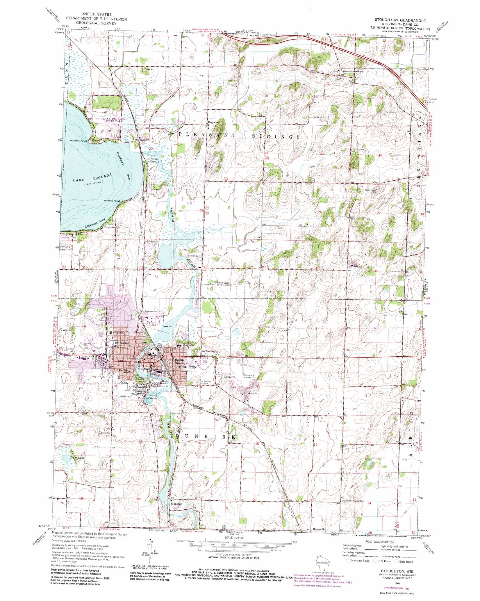
USGS Topo Quad 42089h2 - 1:24,000 scale
| Topo Map Name: | Stoughton |
| USGS Topo Quad ID: | 42089h2 |
| Print Size: | ca. 21 1/4" wide x 27" high |
| Southeast Coordinates: | 42.875° N latitude / 89.125° W longitude |
| Map Center Coordinates: | 42.9375° N latitude / 89.1875° W longitude |
| U.S. State: | WI |
| Filename: | o42089h2.jpg |
| Download Map JPG Image: | Stoughton topo map 1:24,000 scale |
| Map Type: | Topographic |
| Topo Series: | 7.5´ |
| Map Scale: | 1:24,000 |
| Source of Map Images: | United States Geological Survey (USGS) |
| Alternate Map Versions: |
Stoughton WI 1961, updated 1964 Download PDF Buy paper map Stoughton WI 1961, updated 1970 Download PDF Buy paper map Stoughton WI 1961, updated 1983 Download PDF Buy paper map Stoughton WI 2010 Download PDF Buy paper map Stoughton WI 2013 Download PDF Buy paper map Stoughton WI 2016 Download PDF Buy paper map |
1:24,000 Topo Quads surrounding Stoughton
Waunakee |
De Forest |
Sun Prairie |
Marshall |
Waterloo |
Madison West |
Madison East |
Cottage Grove |
Deerfield |
Lake Mills |
Oregon |
Rutland |
Stoughton |
Rockdale |
Busseyville |
Attica |
Evansville |
Cooksville |
Edgerton |
Milton |
Albany |
Orfordville |
Footville |
Janesville West |
Janesville East |
> Back to 42089e1 at 1:100,000 scale
> Back to 42088a1 at 1:250,000 scale
> Back to U.S. Topo Maps home
Stoughton topo map: Gazetteer
Stoughton: Airports
Matson Airport elevation 278m 912′Stoughton: Bays
Atkinson Bay elevation 257m 843′Williams Bay elevation 257m 843′
Stoughton: Capes
Nichols Point elevation 266m 872′Williams Point elevation 264m 866′
Stoughton: Dams
Dunkirk Dam elevation 253m 830′Lake Kegonsa 2WP390 Dam elevation 259m 849′
Stoughton Dam elevation 256m 839′
Stoughton: Lakes
Grass Lake elevation 268m 879′Virgin Lake elevation 275m 902′
Stoughton: Parks
Bjoin Park elevation 259m 849′Division Street Park elevation 258m 846′
East Side Park elevation 270m 885′
Henry Sundby Park elevation 256m 839′
La Follette County Park elevation 259m 849′
Lake Kegonsa State Park elevation 271m 889′
Lowell Street Park elevation 261m 856′
Mandt Park elevation 257m 843′
Pleasant Hill Hights Park elevation 280m 918′
Veterans Park elevation 265m 869′
Viking County Park elevation 259m 849′
Stoughton: Populated Places
Dunkirk elevation 255m 836′Hanerville elevation 266m 872′
Kegonsa elevation 267m 875′
Oak Knoll elevation 267m 875′
Petty Acres elevation 266m 872′
Pleasant Hill elevation 282m 925′
Riverwood Estates elevation 260m 853′
Rolling Acres elevation 269m 882′
Stoughton elevation 267m 875′
Stoughton: Post Offices
Stoughton Post Office elevation 266m 872′Stoughton: Reservoirs
Dunkirk Millpond 442 elevation 253m 830′Lake Kegonsa 410 elevation 259m 849′
Stoughton Millpond 429 elevation 256m 839′
Stoughton digital topo map on disk
Buy this Stoughton topo map showing relief, roads, GPS coordinates and other geographical features, as a high-resolution digital map file on DVD:
Northern Illinois, Northern Indiana & Southwestern Michigan
Buy digital topo maps: Northern Illinois, Northern Indiana & Southwestern Michigan