Rutland Topo Map Wisconsin
To zoom in, hover over the map of Rutland
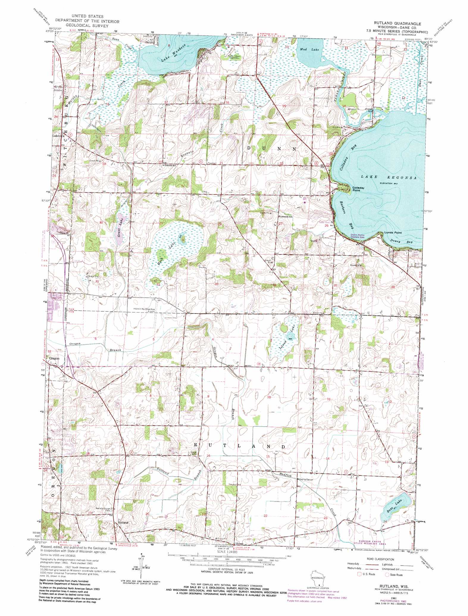
USGS Topo Quad 42089h3 - 1:24,000 scale
| Topo Map Name: | Rutland |
| USGS Topo Quad ID: | 42089h3 |
| Print Size: | ca. 21 1/4" wide x 27" high |
| Southeast Coordinates: | 42.875° N latitude / 89.25° W longitude |
| Map Center Coordinates: | 42.9375° N latitude / 89.3125° W longitude |
| U.S. State: | WI |
| Filename: | o42089h3.jpg |
| Download Map JPG Image: | Rutland topo map 1:24,000 scale |
| Map Type: | Topographic |
| Topo Series: | 7.5´ |
| Map Scale: | 1:24,000 |
| Source of Map Images: | United States Geological Survey (USGS) |
| Alternate Map Versions: |
Rutland WI 1961, updated 1964 Download PDF Buy paper map Rutland WI 1961, updated 1970 Download PDF Buy paper map Rutland WI 1961, updated 1983 Download PDF Buy paper map Rutland WI 2010 Download PDF Buy paper map Rutland WI 2013 Download PDF Buy paper map Rutland WI 2016 Download PDF Buy paper map |
1:24,000 Topo Quads surrounding Rutland
Springfield Corners |
Waunakee |
De Forest |
Sun Prairie |
Marshall |
Middleton |
Madison West |
Madison East |
Cottage Grove |
Deerfield |
Verona |
Oregon |
Rutland |
Stoughton |
Rockdale |
Belleville |
Attica |
Evansville |
Cooksville |
Edgerton |
Monticello |
Albany |
Orfordville |
Footville |
Janesville West |
> Back to 42089e1 at 1:100,000 scale
> Back to 42088a1 at 1:250,000 scale
> Back to U.S. Topo Maps home
Rutland topo map: Gazetteer
Rutland: Airports
McManus Hoonch-Na-Shee-Kaw Airport elevation 282m 925′Quams Marina Seaplane Base elevation 257m 843′
Rutland: Bays
Barbers Bay elevation 257m 843′Colladay Bay elevation 257m 843′
Dewey Bay elevation 257m 843′
Rutland: Capes
Colladay Point elevation 266m 872′Lone Tree Point elevation 257m 843′
Lunds Point elevation 262m 859′
Rutland: Crossings
Red Bridge Crossing elevation 258m 846′Rutland: Lakes
Bass Lake elevation 265m 869′Grass Lake elevation 284m 931′
Hook Lake elevation 283m 928′
Island Lake elevation 274m 898′
Lake Kegonsa elevation 257m 843′
Mud Lake elevation 258m 846′
Rutland: Parks
Hook Lake Bog State Natural Area elevation 283m 928′Jaycee Park elevation 284m 931′
Waubesa Wetlands State Natural Area elevation 258m 846′
Rutland: Populated Places
Bayview Heights elevation 268m 879′Lakeview elevation 270m 885′
Rutland elevation 288m 944′
Rutland: Streams
Door Creek elevation 257m 843′Murphys Creek elevation 257m 843′
Oregon Branch elevation 269m 882′
Rutland Branch elevation 269m 882′
Swan Creek elevation 257m 843′
Rutland digital topo map on disk
Buy this Rutland topo map showing relief, roads, GPS coordinates and other geographical features, as a high-resolution digital map file on DVD:
Northern Illinois, Northern Indiana & Southwestern Michigan
Buy digital topo maps: Northern Illinois, Northern Indiana & Southwestern Michigan