Preston Topo Map Iowa
To zoom in, hover over the map of Preston
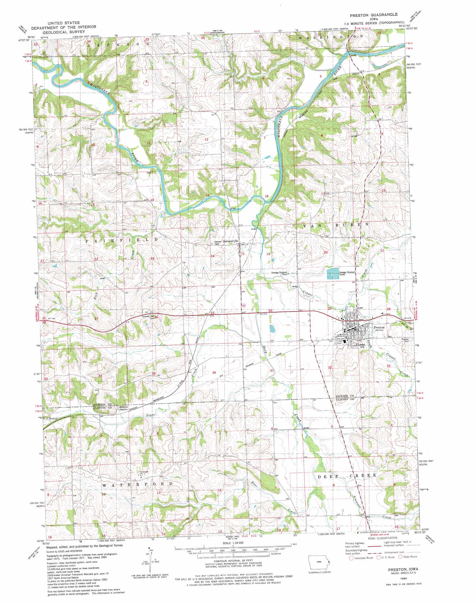
USGS Topo Quad 42090a4 - 1:24,000 scale
| Topo Map Name: | Preston |
| USGS Topo Quad ID: | 42090a4 |
| Print Size: | ca. 21 1/4" wide x 27" high |
| Southeast Coordinates: | 42° N latitude / 90.375° W longitude |
| Map Center Coordinates: | 42.0625° N latitude / 90.4375° W longitude |
| U.S. State: | IA |
| Filename: | o42090a4.jpg |
| Download Map JPG Image: | Preston topo map 1:24,000 scale |
| Map Type: | Topographic |
| Topo Series: | 7.5´ |
| Map Scale: | 1:24,000 |
| Source of Map Images: | United States Geological Survey (USGS) |
| Alternate Map Versions: |
Preston IA 1980, updated 1981 Download PDF Buy paper map Preston IA 2010 Download PDF Buy paper map Preston IA 2013 Download PDF Buy paper map Preston IA 2015 Download PDF Buy paper map |
1:24,000 Topo Quads surrounding Preston
Zwingle |
La Motte |
Bellevue |
Hanover |
Elizabeth |
Fulton |
Andrew |
Springbrook |
Green Island |
Blackhawk |
Maquoketa |
Delmar North |
Preston |
Miles |
Savanna |
Elwood |
Delmar South |
Goose Lake |
Andover |
Clinton Nw |
Grand Mound |
De Witt |
Malone |
Camanche |
Clinton |
> Back to 42090a1 at 1:100,000 scale
> Back to 42090a1 at 1:250,000 scale
> Back to U.S. Topo Maps home
Preston topo map: Gazetteer
Preston: Populated Places
Browns elevation 215m 705′Preston elevation 197m 646′
Rockaway (historical) elevation 188m 616′
Spragueville elevation 202m 662′
Preston: Post Offices
Brown Post Office (historical) elevation 215m 705′Higginsport Post Office (historical) elevation 227m 744′
Preston Post Office elevation 201m 659′
Spragueville Post Office elevation 202m 662′
Preston: Streams
Bear Creek elevation 200m 656′Copper Creek elevation 196m 643′
Deep Creek elevation 186m 610′
Rock Creek elevation 186m 610′
Ryan Creek elevation 193m 633′
Simmons Creek elevation 197m 646′
South Copper Creek elevation 196m 643′
Sugar Creek elevation 194m 636′
Preston: Trails
Jackson County Recreational Trail elevation 188m 616′Preston digital topo map on disk
Buy this Preston topo map showing relief, roads, GPS coordinates and other geographical features, as a high-resolution digital map file on DVD: