Galena Topo Map Illinois
To zoom in, hover over the map of Galena
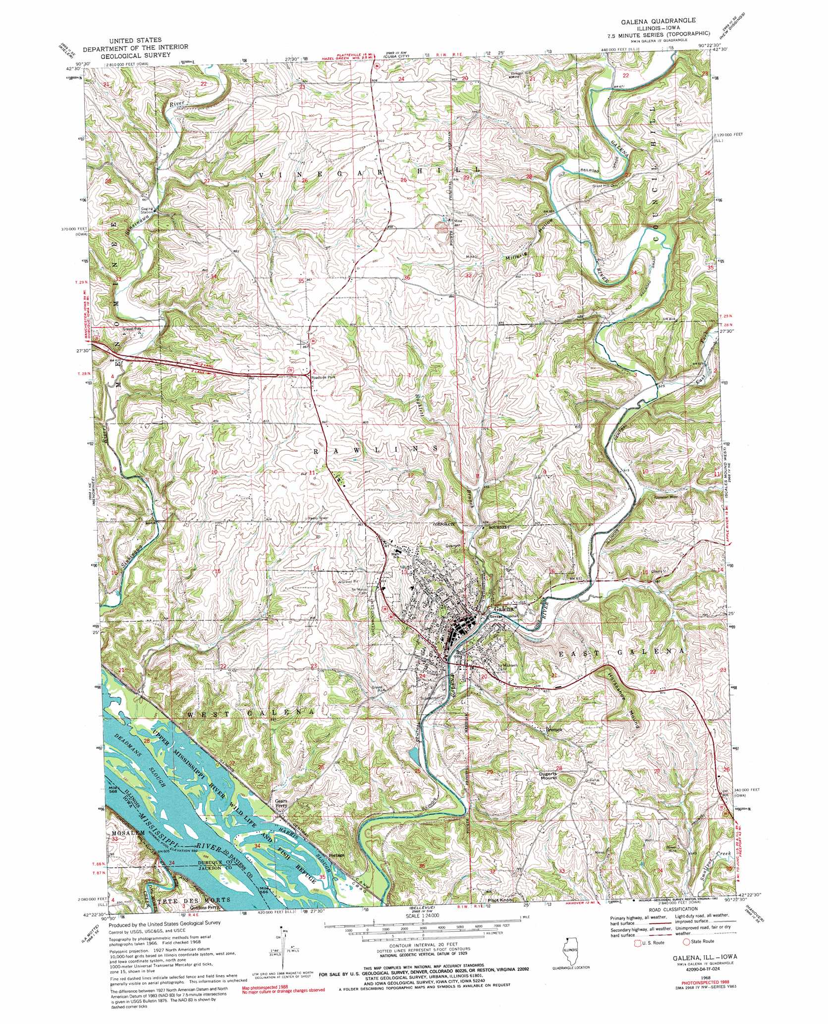
USGS Topo Quad 42090d4 - 1:24,000 scale
| Topo Map Name: | Galena |
| USGS Topo Quad ID: | 42090d4 |
| Print Size: | ca. 21 1/4" wide x 27" high |
| Southeast Coordinates: | 42.375° N latitude / 90.375° W longitude |
| Map Center Coordinates: | 42.4375° N latitude / 90.4375° W longitude |
| U.S. States: | IL, IA |
| Filename: | o42090d4.jpg |
| Download Map JPG Image: | Galena topo map 1:24,000 scale |
| Map Type: | Topographic |
| Topo Series: | 7.5´ |
| Map Scale: | 1:24,000 |
| Source of Map Images: | United States Geological Survey (USGS) |
| Alternate Map Versions: |
Galena IL 1968, updated 1970 Download PDF Buy paper map Galena IL 1968, updated 1989 Download PDF Buy paper map Galena IL 1968, updated 1992 Download PDF Buy paper map Galena IL 1968, updated 1992 Download PDF Buy paper map Galena IL 2010 Download PDF Buy paper map Galena IL 2012 Download PDF Buy paper map Galena IL 2015 Download PDF Buy paper map |
1:24,000 Topo Quads surrounding Galena
Potosi |
Dickeyville |
Platteville |
Belmont |
Calamine |
Dubuque North |
Kieler |
Cuba City |
New Diggings |
Shullsburg |
Dubuque South |
Menominee |
Galena |
Scales Mound West |
Scales Mound East |
Zwingle |
La Motte |
Bellevue |
Hanover |
Elizabeth |
Fulton |
Andrew |
Springbrook |
Green Island |
Blackhawk |
> Back to 42090a1 at 1:100,000 scale
> Back to 42090a1 at 1:250,000 scale
> Back to U.S. Topo Maps home
Galena topo map: Gazetteer
Galena: Airports
Heller Airport elevation 259m 849′Galena: Channels
The Reach elevation 181m 593′Galena: Mines
Appleton Mine elevation 195m 639′Bower Mine elevation 207m 679′
Merry Widow Mine elevation 211m 692′
Pilot Knob Mine elevation 221m 725′
Schoenhard Quarry elevation 219m 718′
Sheboygan Mine elevation 238m 780′
Tenstrike Mine elevation 230m 754′
Vinegar Hill Mine elevation 245m 803′
Galena: Parks
Galena Historic District elevation 189m 620′Grant Park elevation 189m 620′
J Dubuque Monument elevation 206m 675′
Galena: Populated Places
Bremen elevation 209m 685′Galena elevation 193m 633′
Gears Ferry elevation 185m 606′
Millbrig (historical) elevation 201m 659′
Portage elevation 185m 606′
Galena: Post Offices
Gordons Ferry Post Office (historical) elevation 183m 600′Galena: Streams
Deadmans Slough elevation 181m 593′East Fork Galena River elevation 184m 603′
Hughlett Branch elevation 181m 593′
Tete des Morts Creek elevation 180m 590′
Galena: Summits
Dygerts Mound elevation 300m 984′Horseshoe Mound elevation 324m 1062′
Pilot Knob elevation 298m 977′
Galena: Valleys
Millbrig Hollow elevation 199m 652′Galena digital topo map on disk
Buy this Galena topo map showing relief, roads, GPS coordinates and other geographical features, as a high-resolution digital map file on DVD: