Cedar Rapids North Topo Map Iowa
To zoom in, hover over the map of Cedar Rapids North
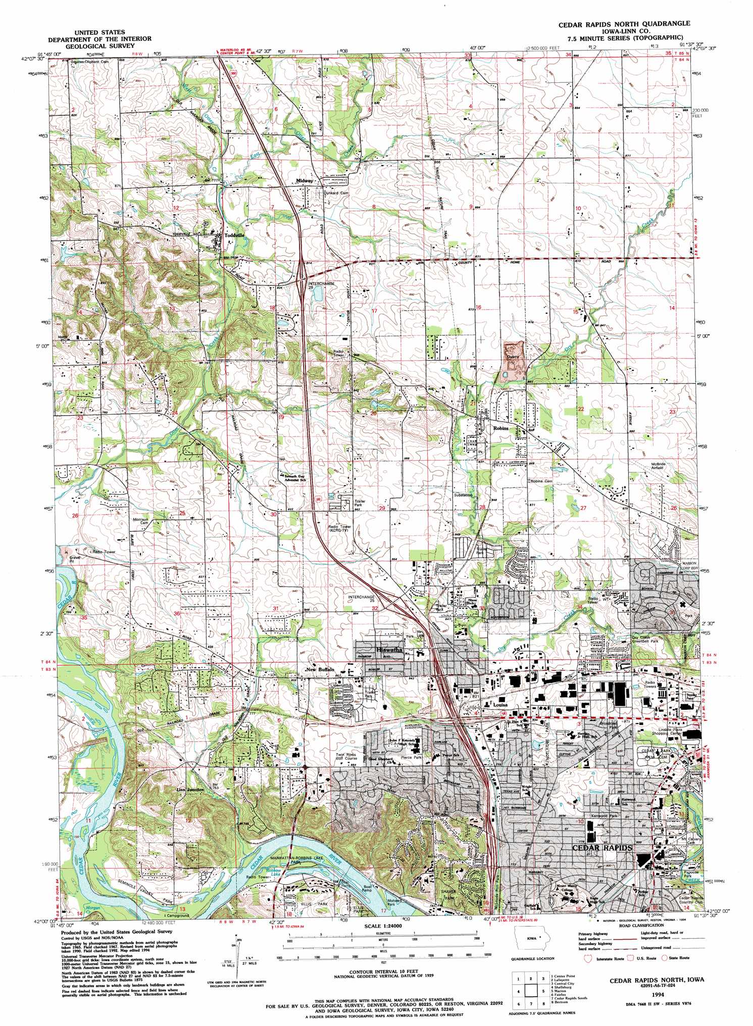
USGS Topo Quad 42091a6 - 1:24,000 scale
| Topo Map Name: | Cedar Rapids North |
| USGS Topo Quad ID: | 42091a6 |
| Print Size: | ca. 21 1/4" wide x 27" high |
| Southeast Coordinates: | 42° N latitude / 91.625° W longitude |
| Map Center Coordinates: | 42.0625° N latitude / 91.6875° W longitude |
| U.S. State: | IA |
| Filename: | o42091a6.jpg |
| Download Map JPG Image: | Cedar Rapids North topo map 1:24,000 scale |
| Map Type: | Topographic |
| Topo Series: | 7.5´ |
| Map Scale: | 1:24,000 |
| Source of Map Images: | United States Geological Survey (USGS) |
| Alternate Map Versions: |
Cedar Rapids North IA 1967, updated 1969 Download PDF Buy paper map Cedar Rapids North IA 1967, updated 1983 Download PDF Buy paper map Cedar Rapids North IA 1975, updated 1976 Download PDF Buy paper map Cedar Rapids North IA 1994, updated 1994 Download PDF Buy paper map Cedar Rapids North IA 1994, updated 1994 Download PDF Buy paper map Cedar Rapids North IA 2010 Download PDF Buy paper map Cedar Rapids North IA 2013 Download PDF Buy paper map Cedar Rapids North IA 2015 Download PDF Buy paper map |
1:24,000 Topo Quads surrounding Cedar Rapids North
Cheney |
Walker |
Troy Mills |
Coggon |
Ryan |
Center Point Nw |
Center Point |
Lafayette |
Central City |
Prairieburg |
Center Point Sw |
Shellsburg |
Cedar Rapids North |
Marion |
Springville |
Newhall |
Fairfax |
Cedar Rapids South |
Bertram |
Mount Vernon |
Middle Amana |
Amana |
Swisher |
Ely |
Solon |
> Back to 42091a1 at 1:100,000 scale
> Back to 42090a1 at 1:250,000 scale
> Back to U.S. Topo Maps home
Cedar Rapids North topo map: Gazetteer
Cedar Rapids North: Airports
Chain Lakes Airpark elevation 247m 810′Chain Lakes Landing Strip elevation 244m 800′
McBride Field elevation 269m 882′
Sherman Airport elevation 262m 859′
Cedar Rapids North: Crossings
Interchange 22 elevation 229m 751′Interchange 23 elevation 239m 784′
Interchange 24A elevation 243m 797′
Interchange 24B elevation 243m 797′
Interchange 25 elevation 261m 856′
Interchange 28 elevation 254m 833′
Cedar Rapids North: Lakes
Robbins Lake elevation 216m 708′Cedar Rapids North: Mines
Robins Quarry elevation 248m 813′Cedar Rapids North: Parks
Broadcast Park elevation 256m 839′Chatham Park elevation 253m 830′
Hiawatha Park elevation 259m 849′
Kenwood Park elevation 238m 780′
Manhattan Robbins Lake Park elevation 219m 718′
McLouds Run Park elevation 225m 738′
Mohawk Park elevation 219m 718′
Noelridge Park elevation 241m 790′
Papoose Park elevation 231m 757′
Pierce Park elevation 260m 853′
Robins Park elevation 256m 839′
Rock Island Botanical State Preserve elevation 261m 856′
Seminole Valley Park elevation 222m 728′
Shaver Park elevation 248m 813′
Tucker Park elevation 248m 813′
Cedar Rapids North: Populated Places
Bali Hai Estates Mobile Home Park elevation 263m 862′Cedar Rapids elevation 247m 810′
Five Seasons Manufactured Home Community elevation 255m 836′
Hiawatha elevation 258m 846′
Hiawatha Oak Brook Court elevation 259m 849′
Lindale Manor elevation 263m 862′
Linn Junction elevation 231m 757′
Louisa elevation 250m 820′
Midway elevation 256m 839′
New Buffalo elevation 252m 826′
Robins elevation 259m 849′
Sunset Village elevation 257m 843′
Toddville elevation 240m 787′
Tower Terrace Mobile Home Park elevation 260m 853′
Cedar Rapids North: Post Offices
Hiawatha Post Office elevation 250m 820′Kenwood Park Post Office (historical) elevation 242m 793′
Linn Junction Post Office (historical) elevation 231m 757′
Louisa Post Office (historical) elevation 250m 820′
Robins Post Office elevation 259m 849′
Toddville Post Office (historical) elevation 235m 770′
Cedar Rapids North: Streams
East Otter Creek elevation 236m 774′Morgan Creek elevation 216m 708′
Silver Creek elevation 221m 725′
West Otter Creek elevation 236m 774′
Cedar Rapids North digital topo map on disk
Buy this Cedar Rapids North topo map showing relief, roads, GPS coordinates and other geographical features, as a high-resolution digital map file on DVD: