Center Point Topo Map Iowa
To zoom in, hover over the map of Center Point
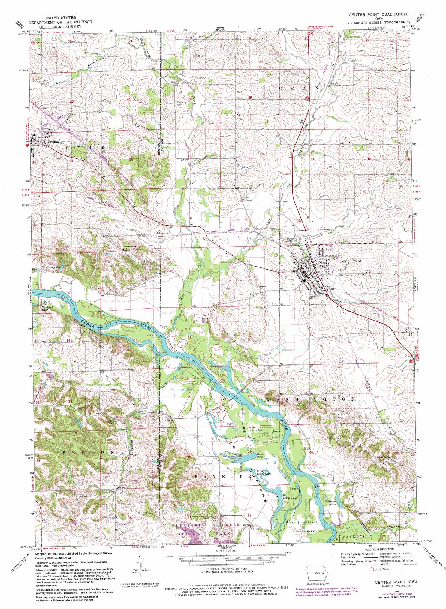
USGS Topo Quad 42091b7 - 1:24,000 scale
| Topo Map Name: | Center Point |
| USGS Topo Quad ID: | 42091b7 |
| Print Size: | ca. 21 1/4" wide x 27" high |
| Southeast Coordinates: | 42.125° N latitude / 91.75° W longitude |
| Map Center Coordinates: | 42.1875° N latitude / 91.8125° W longitude |
| U.S. State: | IA |
| Filename: | o42091b7.jpg |
| Download Map JPG Image: | Center Point topo map 1:24,000 scale |
| Map Type: | Topographic |
| Topo Series: | 7.5´ |
| Map Scale: | 1:24,000 |
| Source of Map Images: | United States Geological Survey (USGS) |
| Alternate Map Versions: |
Center Point IA 1968, updated 1971 Download PDF Buy paper map Center Point IA 1968, updated 1983 Download PDF Buy paper map Center Point IA 2010 Download PDF Buy paper map Center Point IA 2013 Download PDF Buy paper map Center Point IA 2015 Download PDF Buy paper map |
1:24,000 Topo Quads surrounding Center Point
Jesup |
Independence |
Quasqueton |
Winthrop |
Masonville |
Brandon |
Cheney |
Walker |
Troy Mills |
Coggon |
Vinton |
Center Point Nw |
Center Point |
Lafayette |
Central City |
Van Horne |
Center Point Sw |
Shellsburg |
Cedar Rapids North |
Marion |
Blairstown |
Newhall |
Fairfax |
Cedar Rapids South |
Bertram |
> Back to 42091a1 at 1:100,000 scale
> Back to 42090a1 at 1:250,000 scale
> Back to U.S. Topo Maps home
Center Point topo map: Gazetteer
Center Point: Airports
Hannen Airport elevation 276m 905′Center Point: Bends
Lewis Bottoms elevation 227m 744′Center Point: Lakes
Big Lewis Lake elevation 224m 734′Goose Pond elevation 227m 744′
Little Lewis Lake elevation 227m 744′
Williams Lake elevation 224m 734′
Center Point: Mines
Sweeting Quarry elevation 239m 784′Center Point: Parks
John Osborn Historical Marker elevation 254m 833′Lewis Bottoms Access County Park elevation 228m 748′
Lewis Preserve County Park (historical) elevation 226m 741′
Center Point: Populated Places
Center Point elevation 250m 820′Manatheka (historical) elevation 283m 928′
Urbana elevation 286m 938′
Center Point: Post Offices
Center Point Post Office elevation 247m 810′Urbana Post Office elevation 285m 935′
Center Point: Streams
Apple Creek elevation 234m 767′Blue Creek elevation 228m 748′
East Branch Blue Creek elevation 231m 757′
Nelson Creek elevation 225m 738′
Spring Creek elevation 228m 748′
West Branch Blue Creek elevation 243m 797′
Center Point digital topo map on disk
Buy this Center Point topo map showing relief, roads, GPS coordinates and other geographical features, as a high-resolution digital map file on DVD: