Strawberry Point Topo Map Iowa
To zoom in, hover over the map of Strawberry Point
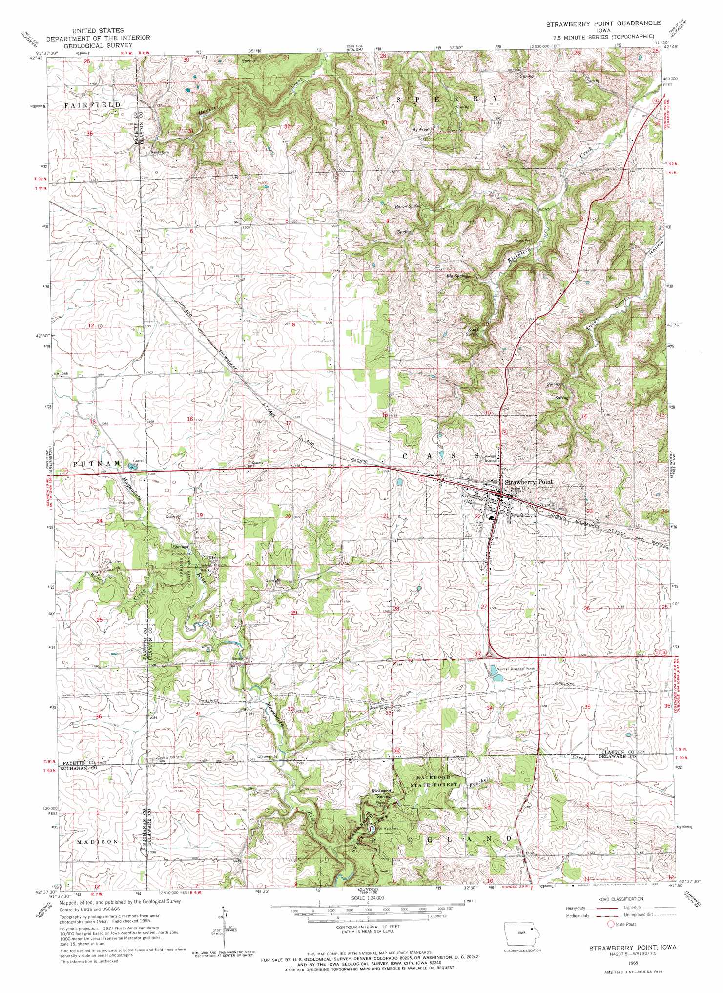
USGS Topo Quad 42091f5 - 1:24,000 scale
| Topo Map Name: | Strawberry Point |
| USGS Topo Quad ID: | 42091f5 |
| Print Size: | ca. 21 1/4" wide x 27" high |
| Southeast Coordinates: | 42.625° N latitude / 91.5° W longitude |
| Map Center Coordinates: | 42.6875° N latitude / 91.5625° W longitude |
| U.S. State: | IA |
| Filename: | o42091f5.jpg |
| Download Map JPG Image: | Strawberry Point topo map 1:24,000 scale |
| Map Type: | Topographic |
| Topo Series: | 7.5´ |
| Map Scale: | 1:24,000 |
| Source of Map Images: | United States Geological Survey (USGS) |
| Alternate Map Versions: |
Strawberry Point IA 1965, updated 1966 Download PDF Buy paper map Strawberry Point IA 2010 Download PDF Buy paper map Strawberry Point IA 2013 Download PDF Buy paper map Strawberry Point IA 2015 Download PDF Buy paper map |
1:24,000 Topo Quads surrounding Strawberry Point
West Union |
Elgin |
Gunder |
Saint Olaf |
Farmersburg |
Fayette |
Wadena |
Volga |
Elkader |
Littleport |
Stanley |
Arlington |
Strawberry Point |
Edgewood |
Garber |
Oelwein Se |
Lamont |
Dundee |
Thorpe |
Greeley |
Quasqueton |
Winthrop |
Masonville |
Manchester |
Earlville |
> Back to 42091e1 at 1:100,000 scale
> Back to 42090a1 at 1:250,000 scale
> Back to U.S. Topo Maps home
Strawberry Point topo map: Gazetteer
Strawberry Point: Airports
Strawberry Point Medical Center Heliport elevation 354m 1161′Strawberry Point: Forests
Backbone State Forest elevation 325m 1066′Strawberry Point: Parks
Joy Springs County Park elevation 323m 1059′Maquoketa River Wildlife Area elevation 338m 1108′
Old Mission Road Historical Marker elevation 370m 1213′
Strawberry Point: Populated Places
Saint Sebald elevation 346m 1135′Strawberry Point elevation 372m 1220′
Strawberry Point: Post Offices
Cass Post Office (historical) elevation 330m 1082′Saint Sebald Post Office (historical) elevation 346m 1135′
Strawberry Point Post Office elevation 371m 1217′
Strawberry Point: Springs
Baron Spring elevation 314m 1030′Big Spring elevation 322m 1056′
Richmond Spring elevation 319m 1046′
South Spring elevation 308m 1010′
Strawberry Point: Streams
Bruce Creek elevation 321m 1053′Fenchel Creek elevation 310m 1017′
Strawberry Point: Valleys
Sugar Camp Hollow elevation 274m 898′Strawberry Point digital topo map on disk
Buy this Strawberry Point topo map showing relief, roads, GPS coordinates and other geographical features, as a high-resolution digital map file on DVD: