Guttenberg Topo Map Wisconsin
To zoom in, hover over the map of Guttenberg
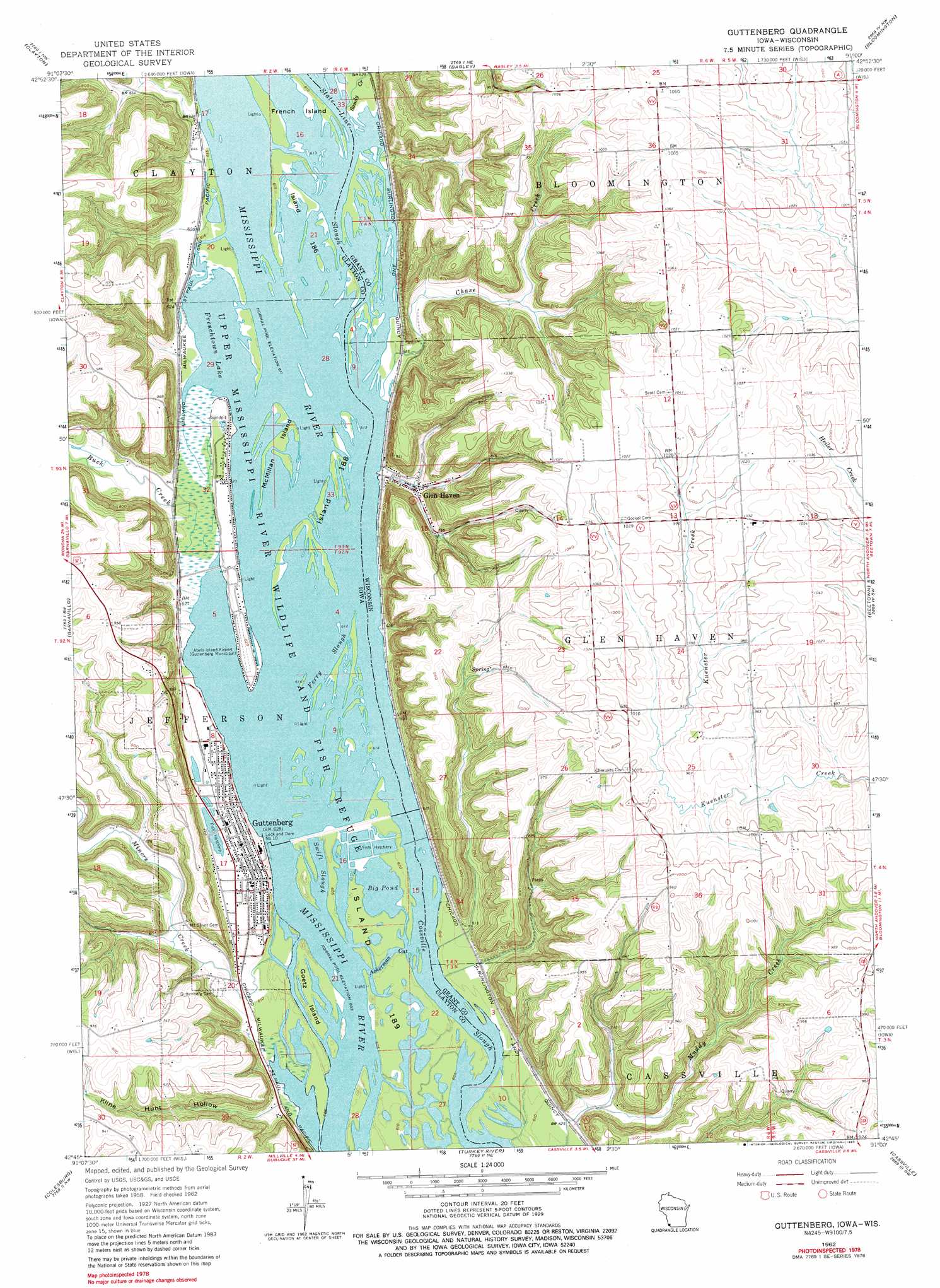
USGS Topo Quad 42091g1 - 1:24,000 scale
| Topo Map Name: | Guttenberg |
| USGS Topo Quad ID: | 42091g1 |
| Print Size: | ca. 21 1/4" wide x 27" high |
| Southeast Coordinates: | 42.75° N latitude / 91° W longitude |
| Map Center Coordinates: | 42.8125° N latitude / 91.0625° W longitude |
| U.S. States: | WI, IA |
| Filename: | o42091g1.jpg |
| Download Map JPG Image: | Guttenberg topo map 1:24,000 scale |
| Map Type: | Topographic |
| Topo Series: | 7.5´ |
| Map Scale: | 1:24,000 |
| Source of Map Images: | United States Geological Survey (USGS) |
| Alternate Map Versions: |
Guttenberg IA 1962, updated 1964 Download PDF Buy paper map Guttenberg IA 1962, updated 1980 Download PDF Buy paper map Guttenberg IA 2010 Download PDF Buy paper map Guttenberg IA 2013 Download PDF Buy paper map Guttenberg IA 2015 Download PDF Buy paper map |
1:24,000 Topo Quads surrounding Guttenberg
Giard |
Prairie Du Chien |
Bridgeport |
Wauzeka West |
Wauzeka East |
Farmersburg |
Clayton |
Bagley |
Bloomington |
Mount Hope |
Littleport |
Garnavillo |
Guttenberg |
Beetown |
Hurricane |
Garber |
Colesburg |
Turkey River |
Cassville |
Balltown |
Greeley |
Petersburg |
New Vienna |
Holy Cross |
Sherrill |
> Back to 42091e1 at 1:100,000 scale
> Back to 42090a1 at 1:250,000 scale
> Back to U.S. Topo Maps home
Guttenberg topo map: Gazetteer
Guttenberg: Airports
Abels Island Airport elevation 188m 616′GAA Private Airport elevation 188m 616′
Walters Heliport elevation 263m 862′
Guttenberg: Channels
Ackerman Cut elevation 186m 610′Cassville Slough elevation 186m 610′
Ferry Slough elevation 186m 610′
State Line Slough elevation 187m 613′
Guttenberg: Dams
Lock and Dam No elevation 197m 646′Lock and Dam Number Ten elevation 187m 613′
Guttenberg: Guts
Swift Slough elevation 186m 610′Guttenberg: Islands
French Island elevation 187m 613′Goetz Island elevation 186m 610′
Island 186 elevation 187m 613′
Island 188 elevation 187m 613′
McMillan Island elevation 186m 610′
Guttenberg: Lakes
Frenchtown Lake elevation 186m 610′Guttenberg: Parks
Guttenberg City Park elevation 195m 639′Guttenberg: Populated Places
Eckards elevation 187m 613′Glen Haven elevation 199m 652′
Guttenberg elevation 191m 626′
Guttenberg: Post Offices
Guttenberg Post Office elevation 193m 633′Guttenberg: Reservoirs
Big Pond elevation 186m 610′Guttenberg: Streams
Buck Creek elevation 191m 626′Chase Creek elevation 187m 613′
Miners Creek elevation 186m 610′
Sandy Creek elevation 187m 613′
State Line Slough elevation 187m 613′
Guttenberg: Valleys
Kline Hunt Hollow elevation 190m 623′Guttenberg digital topo map on disk
Buy this Guttenberg topo map showing relief, roads, GPS coordinates and other geographical features, as a high-resolution digital map file on DVD: