Bagley Topo Map Wisconsin
To zoom in, hover over the map of Bagley
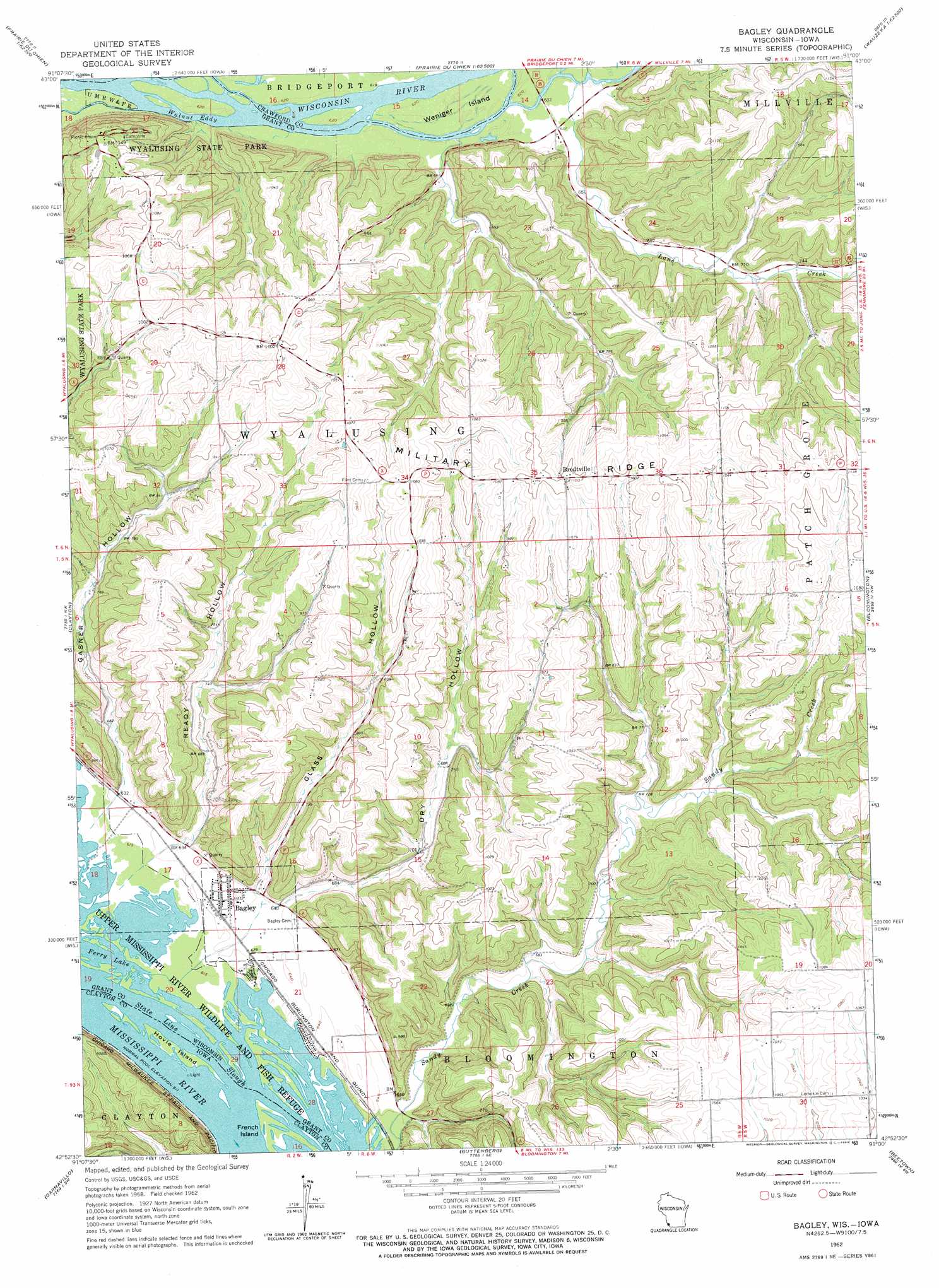
USGS Topo Quad 42091h1 - 1:24,000 scale
| Topo Map Name: | Bagley |
| USGS Topo Quad ID: | 42091h1 |
| Print Size: | ca. 21 1/4" wide x 27" high |
| Southeast Coordinates: | 42.875° N latitude / 91° W longitude |
| Map Center Coordinates: | 42.9375° N latitude / 91.0625° W longitude |
| U.S. States: | WI, IA |
| Filename: | o42091h1.jpg |
| Download Map JPG Image: | Bagley topo map 1:24,000 scale |
| Map Type: | Topographic |
| Topo Series: | 7.5´ |
| Map Scale: | 1:24,000 |
| Source of Map Images: | United States Geological Survey (USGS) |
| Alternate Map Versions: |
Bagley WI 1962, updated 1964 Download PDF Buy paper map Brodtville WI 2010 Download PDF Buy paper map Brodtville WI 2013 Download PDF Buy paper map Brodtville WI 2016 Download PDF Buy paper map |
1:24,000 Topo Quads surrounding Bagley
Waterville |
Harpers Ferry |
Eastman |
Crowley Ridge |
Steuben |
Giard |
Prairie Du Chien |
Bridgeport |
Wauzeka West |
Wauzeka East |
Farmersburg |
Clayton |
Bagley |
Bloomington |
Mount Hope |
Littleport |
Garnavillo |
Guttenberg |
Beetown |
Hurricane |
Garber |
Colesburg |
Turkey River |
Cassville |
Balltown |
> Back to 42091e1 at 1:100,000 scale
> Back to 42090a1 at 1:250,000 scale
> Back to U.S. Topo Maps home
Bagley topo map: Gazetteer
Bagley: Channels
State Line Slough elevation 187m 613′Bagley: Islands
Hovie Island elevation 187m 613′Weniger Island elevation 188m 616′
Bagley: Lakes
Ferry Lake elevation 187m 613′Bagley: Parks
Gasner Hollow Prairie State Natural Area elevation 289m 948′Wyalusing Hardwood Forest State Natural Area elevation 233m 764′
Wyalusing State Park elevation 324m 1062′
Wyalusing Walnut Forest State Natural Area elevation 226m 741′
Bagley: Populated Places
Bagley elevation 194m 636′Brodtville elevation 337m 1105′
Bagley: Rapids
Walnut Eddy elevation 207m 679′Bagley: Streams
Lane Creek elevation 190m 623′Bagley: Valleys
Dry Hollow elevation 197m 646′Gasner Hollow elevation 191m 626′
Glass Hollow elevation 198m 649′
Ready Hollow elevation 194m 636′
Bagley digital topo map on disk
Buy this Bagley topo map showing relief, roads, GPS coordinates and other geographical features, as a high-resolution digital map file on DVD: