Boone West Topo Map Iowa
To zoom in, hover over the map of Boone West
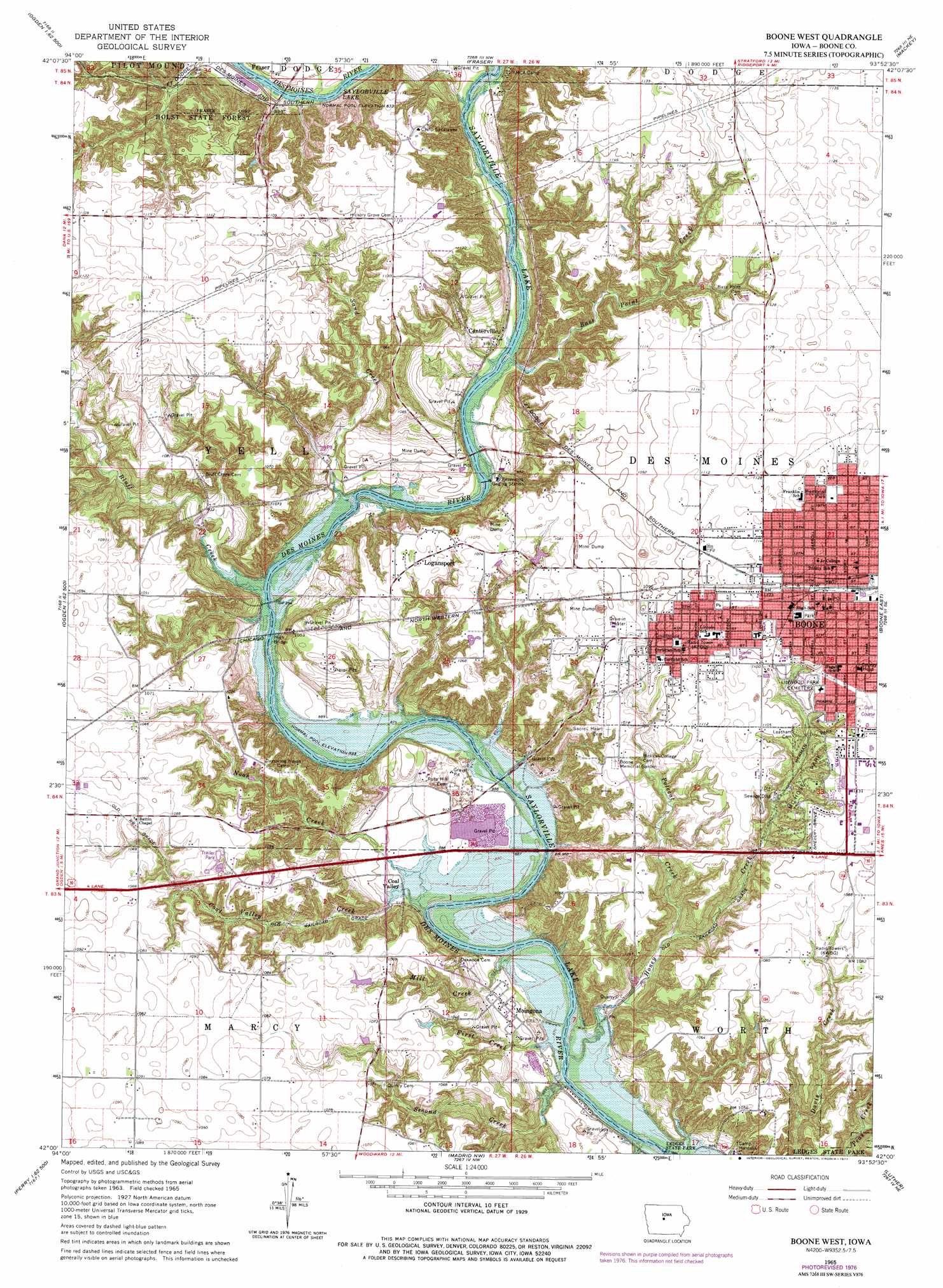
USGS Topo Quad 42093a8 - 1:24,000 scale
| Topo Map Name: | Boone West |
| USGS Topo Quad ID: | 42093a8 |
| Print Size: | ca. 21 1/4" wide x 27" high |
| Southeast Coordinates: | 42° N latitude / 93.875° W longitude |
| Map Center Coordinates: | 42.0625° N latitude / 93.9375° W longitude |
| U.S. State: | IA |
| Filename: | o42093a8.jpg |
| Download Map JPG Image: | Boone West topo map 1:24,000 scale |
| Map Type: | Topographic |
| Topo Series: | 7.5´ |
| Map Scale: | 1:24,000 |
| Source of Map Images: | United States Geological Survey (USGS) |
| Alternate Map Versions: |
Boone West IA 1965, updated 1966 Download PDF Buy paper map Boone West IA 1965, updated 1977 Download PDF Buy paper map Boone West IA 2010 Download PDF Buy paper map Boone West IA 2013 Download PDF Buy paper map Boone West IA 2015 Download PDF Buy paper map |
1:24,000 Topo Quads surrounding Boone West
Harcourt |
Lehigh |
Stratford |
Stanhope |
Jewell |
Lanyon |
Boxholm |
Fraser |
Mackey |
Ames Nw |
Grand Junction |
Ogden |
Boone West |
Boone East |
Ames West |
Rippey |
Berkley |
Madrid Nw |
Luther |
Slater |
Dawson |
Perry |
Woodward |
Granger |
Polk City |
> Back to 42093a1 at 1:100,000 scale
> Back to 42092a1 at 1:250,000 scale
> Back to U.S. Topo Maps home
Boone West topo map: Gazetteer
Boone West: Bridges
Boone Bridge elevation 265m 869′Boone Bridge Two elevation 265m 869′
High Bridge elevation 265m 869′
Boone West: Forests
Holst State Forest elevation 336m 1102′Boone West: Parks
Anderson Park elevation 351m 1151′Birthplace of Mamie D Eisenhower Historical Marker elevation 344m 1128′
Cummings Park elevation 338m 1108′
Dragoon Trail in Boone County Historical Marker elevation 338m 1108′
Franklin Park elevation 345m 1131′
Goeppinger Field elevation 341m 1118′
Herman Park elevation 321m 1053′
Kate Shelley Memorial Park elevation 280m 918′
Little League Park elevation 335m 1099′
McHose Park elevation 340m 1115′
Memorial Park elevation 346m 1135′
Miles-Lee Park elevation 333m 1092′
Boone West: Populated Places
Boone elevation 346m 1135′Centerville elevation 279m 915′
Coal Valley elevation 272m 892′
Country Aire Mobile Home Park elevation 327m 1072′
Logansport elevation 325m 1066′
Moingona elevation 280m 918′
Boone West: Post Offices
Boone Post Office elevation 345m 1131′Boonesboro Post Office (historical) elevation 338m 1108′
Incline Post Office (historical) elevation 323m 1059′
Moingona Post Office (historical) elevation 280m 918′
River Side Post Office (historical) elevation 323m 1059′
Riverside Post Office (historical) elevation 338m 1108′
Boone West: Streams
Bass Point Creek elevation 268m 879′Bluff Creek elevation 265m 869′
Coal Valley Creek elevation 262m 859′
First Creek elevation 262m 859′
Honey Creek elevation 262m 859′
Mill Creek elevation 262m 859′
Noah Creek elevation 263m 862′
Polecat Creek elevation 281m 921′
Sand Creek elevation 265m 869′
Second Creek elevation 262m 859′
Third Creek elevation 262m 859′
Boone West digital topo map on disk
Buy this Boone West topo map showing relief, roads, GPS coordinates and other geographical features, as a high-resolution digital map file on DVD: