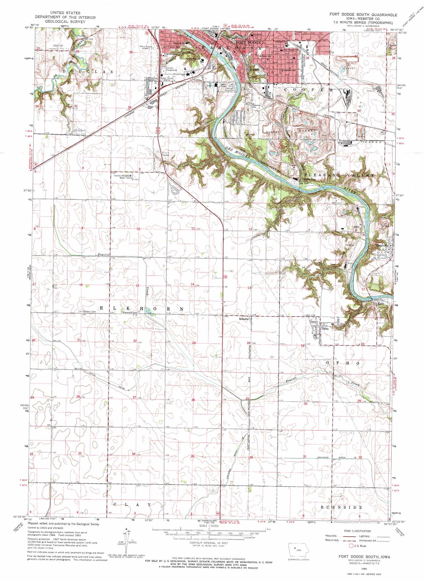
Fort Dodge South Topo Map Iowa
To zoom in, hover over the map of Fort Dodge South
USGS Topo Quad 42094d2 - 1:24,000 scale
| Topo Map Name: | Fort Dodge South |
| USGS Topo Quad ID: | 42094d2 |
| Print Size: | ca. 21 1/4" wide x 27" high |
| Southeast Coordinates: | 42.375° N latitude / 94.125° W longitude |
| Map Center Coordinates: | 42.4375° N latitude / 94.1875° W longitude |
| U.S. State: | IA |
| Filename: | o42094d2.jpg |
| Download Map JPG Image: | Fort Dodge South topo map 1:24,000 scale |
| Map Type: | Topographic |
| Topo Series: | 7.5´ |
| Map Scale: | 1:24,000 |
| Source of Map Images: | United States Geological Survey (USGS) |
| Alternate Map Versions: |
Fort Dodge South IA 1965, updated 1966 Download PDF Buy paper map Fort Dodge South IA 2010 Download PDF Buy paper map Fort Dodge South IA 2013 Download PDF Buy paper map Fort Dodge South IA 2015 Download PDF Buy paper map |
1:24,000 Topo Quads surrounding Fort Dodge South
Gilmore City |
Umque |
Humboldt |
Thor |
Eagle Grove |
Gilmore City Sw |
Clare |
Fort Dodge North |
Vincent |
Eagle Grove Sw |
Knierim |
Moorland |
Fort Dodge South |
Evanston |
Duncombe |
Farnhamville |
Gowrie |
Harcourt |
Lehigh |
Stratford |
Churdan |
Paton |
Lanyon |
Boxholm |
Fraser |
> Back to 42094a1 at 1:100,000 scale
> Back to 42094a1 at 1:250,000 scale
> Back to U.S. Topo Maps home
Fort Dodge South topo map: Gazetteer
Fort Dodge South: Airports
Trinity Regional Hospital Heliport elevation 327m 1072′Fort Dodge South: Canals
Ditch Number 96 elevation 341m 1118′Drainage Ditch 19 elevation 339m 1112′
Drainage Ditch Number 29 elevation 342m 1122′
Fort Dodge South: Parks
Bob Hay Memorial Conservation Area elevation 332m 1089′Dragoon Trail Historical Marker elevation 341m 1118′
East Lawn Acres Park elevation 338m 1108′
Leif Ericson Park elevation 339m 1112′
Linwood Hanson Park elevation 339m 1112′
Liska-Stanek Prairie elevation 345m 1131′
Mason Park elevation 323m 1059′
Old Arnold House Historical Marker elevation 341m 1118′
Oleson Park elevation 327m 1072′
Fort Dodge South: Populated Places
Coalville elevation 339m 1112′Cypsum City (historical) elevation 339m 1112′
Fort Dodge elevation 340m 1115′
Kalo elevation 297m 974′
Otho elevation 342m 1122′
Roberts elevation 341m 1118′
Shady Oak elevation 300m 984′
West Fort Dodge (historical) elevation 344m 1128′
Fort Dodge South: Post Offices
Carbon Junction Post Office (historical) elevation 338m 1108′Carbon Post Office (historical) elevation 338m 1108′
Coalville Post Office (historical) elevation 339m 1112′
Greenside Post Office (historical) elevation 342m 1122′
Gypsum Post Office (historical) elevation 338m 1108′
Jackson Centre Post Office (historical) elevation 346m 1135′
Kalo Post Office (historical) elevation 297m 974′
Otho Post Office elevation 342m 1122′
Shady Oak Post Office (historical) elevation 300m 984′
Fort Dodge South: Streams
Deer Creek elevation 295m 967′Elkhorn Creek elevation 300m 984′
Gypsum Creek elevation 292m 958′
Fort Dodge South: Trails
Fort Dodge Nature Trail elevation 341m 1118′Fort Dodge South digital topo map on disk
Buy this Fort Dodge South topo map showing relief, roads, GPS coordinates and other geographical features, as a high-resolution digital map file on DVD: