Storm Lake Topo Map Iowa
To zoom in, hover over the map of Storm Lake
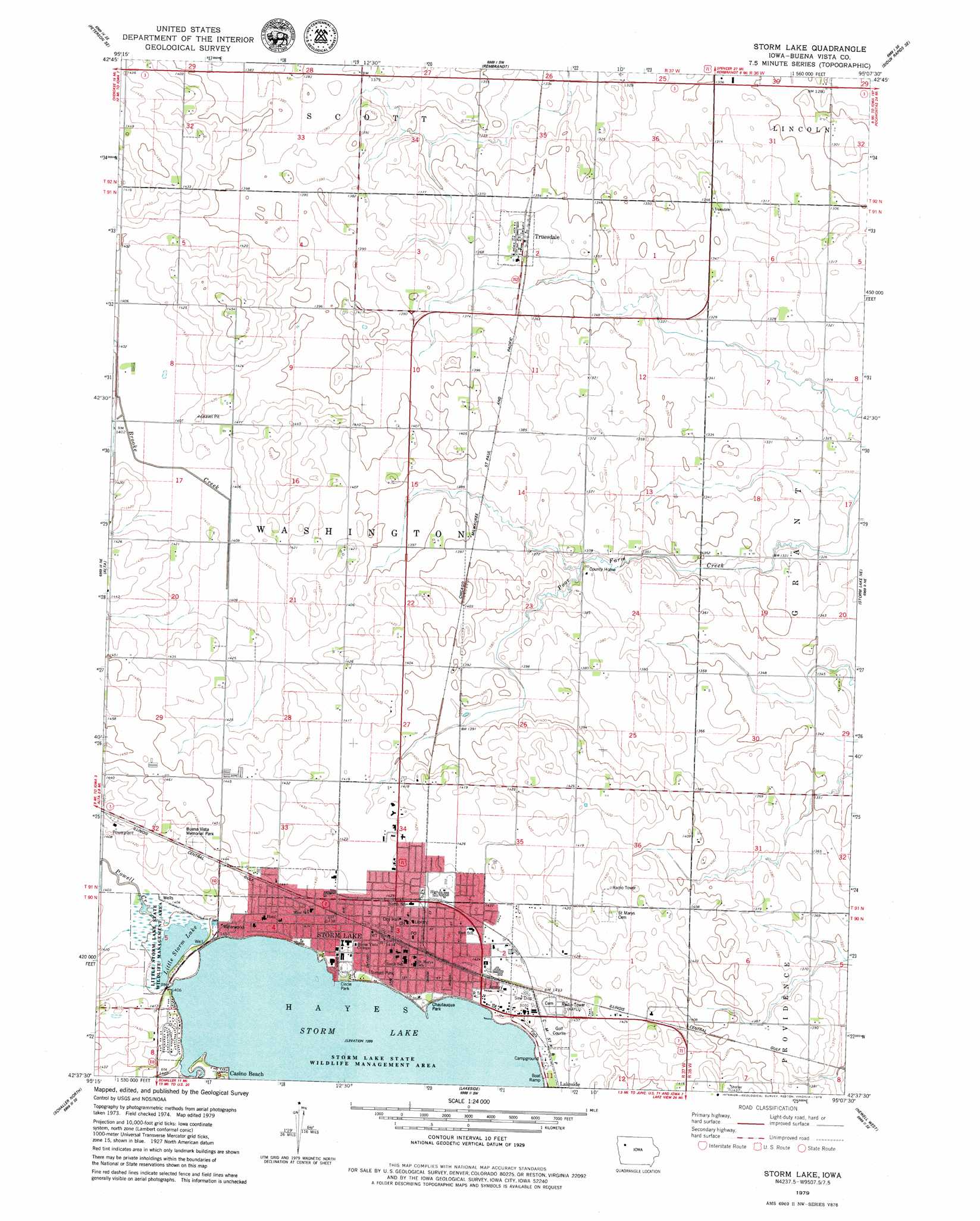
USGS Topo Quad 42095f2 - 1:24,000 scale
| Topo Map Name: | Storm Lake |
| USGS Topo Quad ID: | 42095f2 |
| Print Size: | ca. 21 1/4" wide x 27" high |
| Southeast Coordinates: | 42.625° N latitude / 95.125° W longitude |
| Map Center Coordinates: | 42.6875° N latitude / 95.1875° W longitude |
| U.S. State: | IA |
| Filename: | o42095f2.jpg |
| Download Map JPG Image: | Storm Lake topo map 1:24,000 scale |
| Map Type: | Topographic |
| Topo Series: | 7.5´ |
| Map Scale: | 1:24,000 |
| Source of Map Images: | United States Geological Survey (USGS) |
| Alternate Map Versions: |
Storm Lake IA 1979, updated 1979 Download PDF Buy paper map Storm Lake IA 2010 Download PDF Buy paper map Storm Lake IA 2013 Download PDF Buy paper map Storm Lake IA 2015 Download PDF Buy paper map |
1:24,000 Topo Quads surrounding Storm Lake
Sutherland East |
Peterson |
Sioux Rapids |
Webb |
Rush Lake West |
Peterson Sw |
Peterson Se |
Rembrandt |
Sioux Rapids Se |
Albert City |
Aurelia |
Alta |
Storm Lake |
Storm Lake Ne |
Varina |
Galva |
Schaller North |
Lakeside |
Newell West |
Newell East |
Ida Grove Nw |
Schaller South |
Early |
Sac City West |
Sac City East |
> Back to 42095e1 at 1:100,000 scale
> Back to 42094a1 at 1:250,000 scale
> Back to U.S. Topo Maps home
Storm Lake topo map: Gazetteer
Storm Lake: Beaches
Casino Beach elevation 425m 1394′Storm Lake: Lakes
Little Storm Lake elevation 425m 1394′Storm Lake elevation 425m 1394′
Storm Lake: Parks
Bradford Field elevation 429m 1407′Chautauqua Park elevation 430m 1410′
Circle Park elevation 427m 1400′
Dedication to Pioneers Historical Marker elevation 427m 1400′
Emerald Park elevation 428m 1404′
Frank Starr Park elevation 428m 1404′
J Leslie Rollins Stadium elevation 429m 1407′
Kolb Memorial Park elevation 429m 1407′
Little Storm Lake Game Management Area elevation 427m 1400′
Living Heritage Tree Museum elevation 433m 1420′
Radio Park elevation 430m 1410′
Scout Park elevation 429m 1407′
Storm Lake State Wildlife Management Area elevation 425m 1394′
Sunrise Park elevation 428m 1404′
Sunset Park elevation 433m 1420′
Victory Arch elevation 431m 1414′
Storm Lake: Populated Places
Storm Lake elevation 433m 1420′Truesdale elevation 417m 1368′
Vista Estates Mobile Home Park elevation 434m 1423′
Storm Lake: Post Offices
Plum Post Office (historical) elevation 427m 1400′Storm Lake Post Office elevation 438m 1437′
Truesdale Post Office elevation 417m 1368′
Storm Lake: Streams
Powell Creek elevation 428m 1404′Storm Lake: Trails
Storm Lake Laketrail elevation 433m 1420′Storm Lake digital topo map on disk
Buy this Storm Lake topo map showing relief, roads, GPS coordinates and other geographical features, as a high-resolution digital map file on DVD: