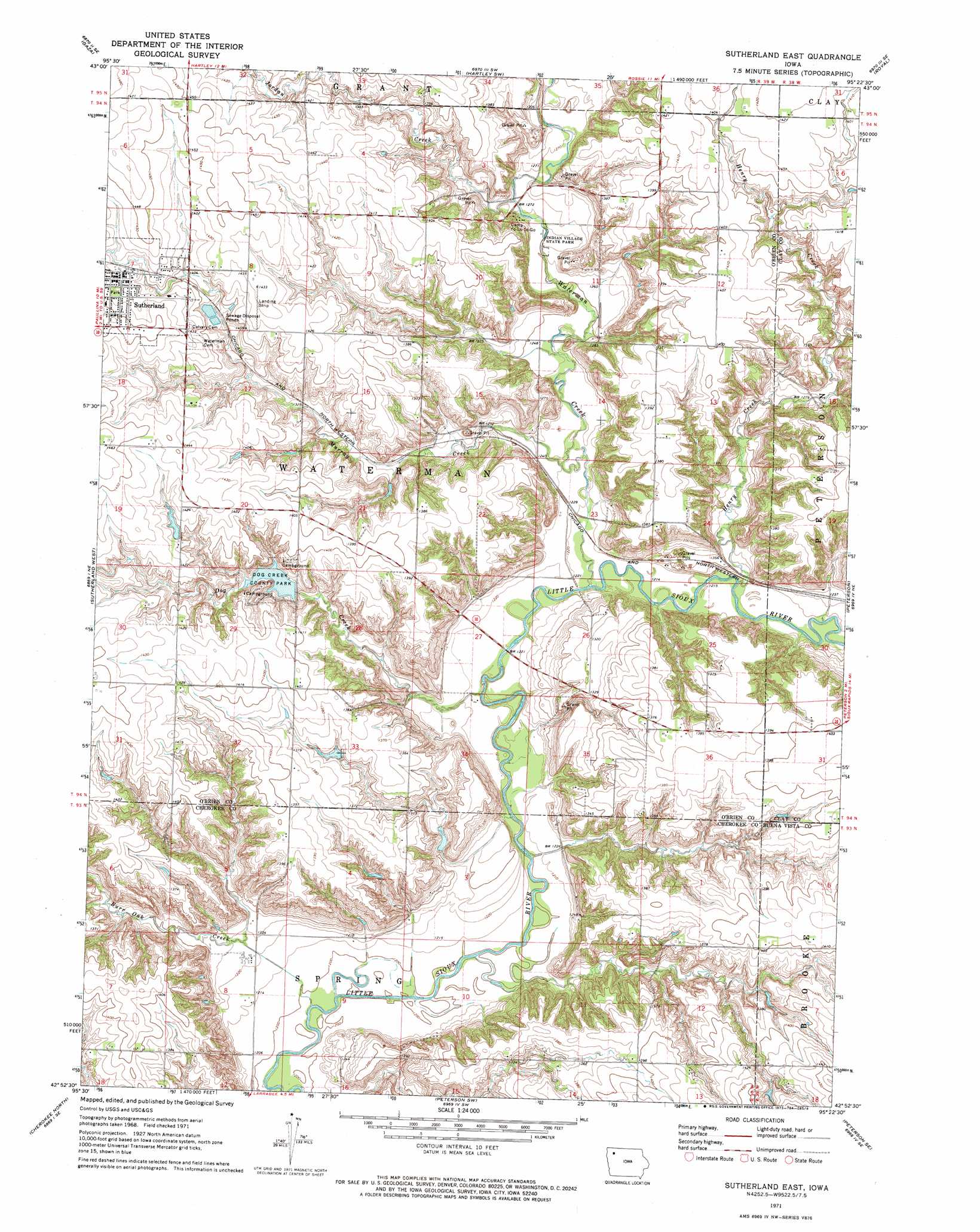
Sutherland East Topo Map Iowa
To zoom in, hover over the map of Sutherland East
USGS Topo Quad 42095h4 - 1:24,000 scale
| Topo Map Name: | Sutherland East |
| USGS Topo Quad ID: | 42095h4 |
| Print Size: | ca. 21 1/4" wide x 27" high |
| Southeast Coordinates: | 42.875° N latitude / 95.375° W longitude |
| Map Center Coordinates: | 42.9375° N latitude / 95.4375° W longitude |
| U.S. State: | IA |
| Filename: | o42095h4.jpg |
| Download Map JPG Image: | Sutherland East topo map 1:24,000 scale |
| Map Type: | Topographic |
| Topo Series: | 7.5´ |
| Map Scale: | 1:24,000 |
| Source of Map Images: | United States Geological Survey (USGS) |
| Alternate Map Versions: |
Sutherland East IA 1971, updated 1973 Download PDF Buy paper map Sutherland East IA 2010 Download PDF Buy paper map Sutherland East IA 2013 Download PDF Buy paper map Sutherland East IA 2015 Download PDF Buy paper map |
1:24,000 Topo Quads surrounding Sutherland East
Sanborn |
Plessis |
Hartley |
Everly |
Spencer |
Primghar |
Gaza |
Hartley Sw |
Royal |
Creenville |
Paullina |
Sutherland West |
Sutherland East |
Peterson |
Sioux Rapids |
Cleghorn |
Cherokee North |
Peterson Sw |
Peterson Se |
Rembrandt |
Quimby |
Cherokee South |
Aurelia |
Alta |
Storm Lake |
> Back to 42095e1 at 1:100,000 scale
> Back to 42094a1 at 1:250,000 scale
> Back to U.S. Topo Maps home
Sutherland East topo map: Gazetteer
Sutherland East: Dams
Dog Creek Dam elevation 400m 1312′Sutherland East: Parks
Dog Creek County Park elevation 419m 1374′First Settlement in O'Brien County Historical Marker elevation 404m 1325′
Indian Village State Park elevation 385m 1263′
McCormack Area elevation 382m 1253′
Negus Recreation Area elevation 429m 1407′
Waterman Prairie Wildlife Management Area elevation 376m 1233′
Sutherland East: Populated Places
Sutherland elevation 435m 1427′Waterman elevation 398m 1305′
Sutherland East: Post Offices
O'Brien Post Office (historical) elevation 422m 1384′Sutherland Post Office elevation 436m 1430′
Waterman Post Office (historical) elevation 398m 1305′
Sutherland East: Streams
Dog Creek elevation 368m 1207′Henry Creek elevation 369m 1210′
Jordan Creek elevation 384m 1259′
Murray Creek elevation 372m 1220′
Waterman Creek elevation 369m 1210′
Sutherland East digital topo map on disk
Buy this Sutherland East topo map showing relief, roads, GPS coordinates and other geographical features, as a high-resolution digital map file on DVD: