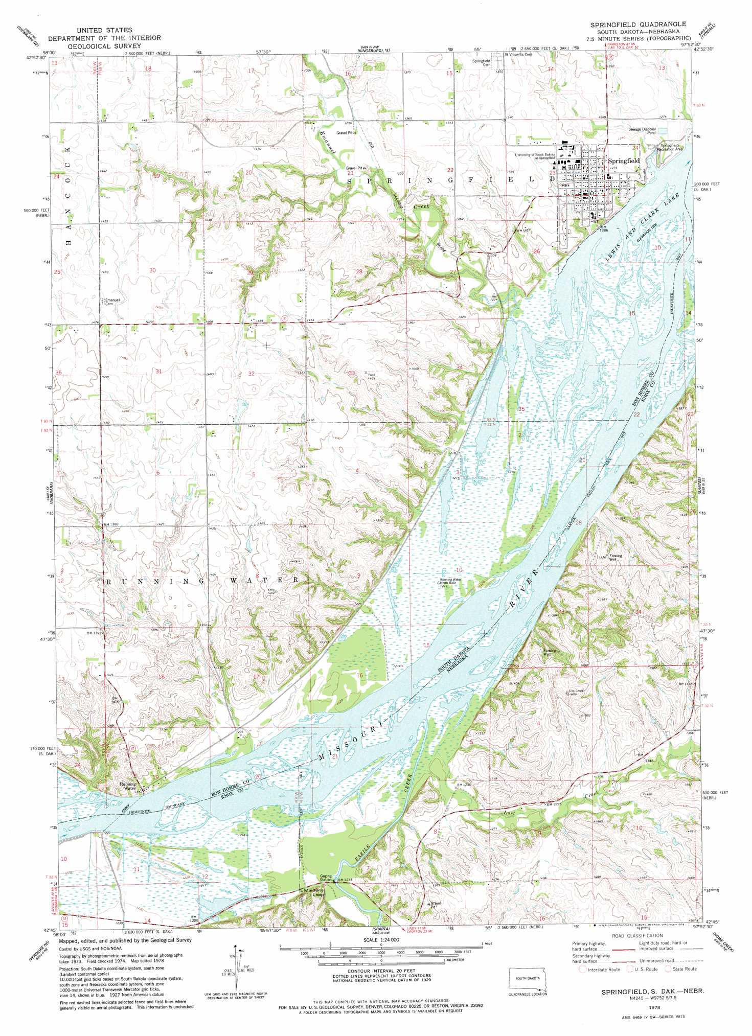
Springfield Topo Map South Dakota
To zoom in, hover over the map of Springfield
USGS Topo Quad 42097g8 - 1:24,000 scale
| Topo Map Name: | Springfield |
| USGS Topo Quad ID: | 42097g8 |
| Print Size: | ca. 21 1/4" wide x 27" high |
| Southeast Coordinates: | 42.75° N latitude / 97.875° W longitude |
| Map Center Coordinates: | 42.8125° N latitude / 97.9375° W longitude |
| U.S. States: | SD, NE |
| Filename: | o42097g8.jpg |
| Download Map JPG Image: | Springfield topo map 1:24,000 scale |
| Map Type: | Topographic |
| Topo Series: | 7.5´ |
| Map Scale: | 1:24,000 |
| Source of Map Images: | United States Geological Survey (USGS) |
| Alternate Map Versions: |
Springfield SD 1977, updated 1979 Download PDF Buy paper map Springfield SD 1978, updated 1979 Download PDF Buy paper map Springfield SD 2012 Download PDF Buy paper map Springfield SD 2015 Download PDF Buy paper map |
1:24,000 Topo Quads surrounding Springfield
Dante |
Avon |
Haucks Lake |
Tripp Se |
Kloucek Lake |
Niobrara Nw |
Niobrara Ne |
Kingsburg |
Tyndall |
Tabor |
Verdel |
Niobrara |
Springfield |
Santee |
Bon Homme Colony |
Pishelville |
Verdigre Ne |
Sparta |
Howe Creek |
Lindy |
Walnut |
Verdigre |
Center West |
Center East |
Bloomfield |
> Back to 42097e1 at 1:100,000 scale
> Back to 42096a1 at 1:250,000 scale
> Back to U.S. Topo Maps home
Springfield topo map: Gazetteer
Springfield: Parks
Bazile Creek State Wildlife Management Area elevation 368m 1207′Emanuel Creek Recreation Area elevation 372m 1220′
Springfield Recreation Area elevation 385m 1263′
Springfield: Populated Places
Springfield elevation 396m 1299′Springfield: Post Offices
Breckenridge Post Office (historical) elevation 377m 1236′Springfield: Streams
Bazile Creek elevation 367m 1204′Emanuel Creek elevation 372m 1220′
Lost Creek elevation 368m 1207′
Springfield: Summits
Maidens Leap elevation 395m 1295′Springfield digital topo map on disk
Buy this Springfield topo map showing relief, roads, GPS coordinates and other geographical features, as a high-resolution digital map file on DVD: