Turpin Lake East Topo Map Nebraska
To zoom in, hover over the map of Turpin Lake East
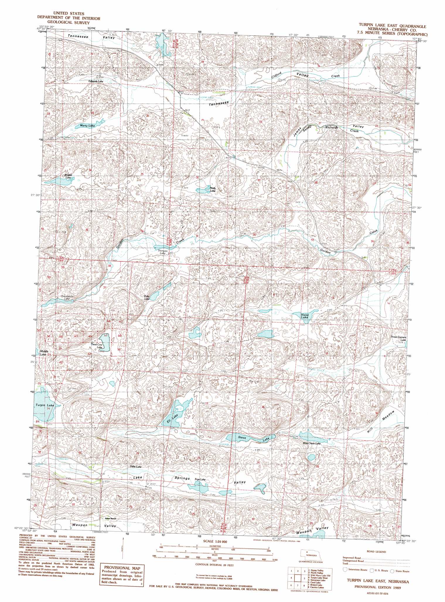
USGS Topo Quad 42101d7 - 1:24,000 scale
| Topo Map Name: | Turpin Lake East |
| USGS Topo Quad ID: | 42101d7 |
| Print Size: | ca. 21 1/4" wide x 27" high |
| Southeast Coordinates: | 42.375° N latitude / 101.75° W longitude |
| Map Center Coordinates: | 42.4375° N latitude / 101.8125° W longitude |
| U.S. State: | NE |
| Filename: | O42101D7.jpg |
| Download Map JPG Image: | Turpin Lake East topo map 1:24,000 scale |
| Map Type: | Topographic |
| Topo Series: | 7.5´ |
| Map Scale: | 1:24,000 |
| Source of Map Images: | United States Geological Survey (USGS) |
| Alternate Map Versions: |
Turpin Lake East NE 1989, updated 1989 Download PDF Buy paper map Turpin Lake East NE 2011 Download PDF Buy paper map Turpin Lake East NE 2014 Download PDF Buy paper map |
1:24,000 Topo Quads surrounding Turpin Lake East
Rushville 4 Ne |
Pole Creek Valley |
Bornemann Lake |
Wild Mare Lake Nw |
Wild Mare Lake |
Rushville 4 Se |
Gypsy Valley |
North Valley |
Wild Mare Lake Sw |
Wild Mare Lake Se |
Billys Lake |
Turpin Lake West |
Turpin Lake East |
Steverson Lake |
Round Lake |
Wolford Valley |
Card Lake |
Bristol Lake |
School Section Lake |
Hill Lake |
Lowe Valley |
Camp Valley |
Mother Lake |
Whitman Nw |
Sunflower Lake |
> Back to 42101a1 at 1:100,000 scale
> Back to 42100a1 at 1:250,000 scale
> Back to U.S. Topo Maps home
Turpin Lake East topo map: Gazetteer
Turpin Lake East: Basins
James Valley elevation 1096m 3595′Lake Springs Valley elevation 1134m 3720′
Tennessee Valley elevation 1096m 3595′
Turpin Lake East: Dams
Gordon Valley Dam elevation 1139m 3736′Turpin Lake East: Lakes
Blue Crane Lake elevation 1119m 3671′Bobtail Lake elevation 1128m 3700′
Chamberlin Lake elevation 1131m 3710′
Dead Cow Lake elevation 1125m 3690′
Dillie Lake elevation 1134m 3720′
Edwards Lake elevation 1114m 3654′
Ell Lake elevation 1123m 3684′
Frye Lake elevation 1131m 3710′
Holst Lake elevation 1113m 3651′
Mally Lake elevation 1113m 3651′
Marty Lake elevation 1119m 3671′
Ruby Lake elevation 1119m 3671′
Steve Lake elevation 1119m 3671′
Thirty-Six Lake elevation 1119m 3671′
Turpin Lake elevation 1137m 3730′
Turpin Lake East: Reservoirs
Gordon Valley Reservoir elevation 1139m 3736′Turpin Lake East: Swamps
Hill Meadow elevation 1108m 3635′Turpin Lake East digital topo map on disk
Buy this Turpin Lake East topo map showing relief, roads, GPS coordinates and other geographical features, as a high-resolution digital map file on DVD: