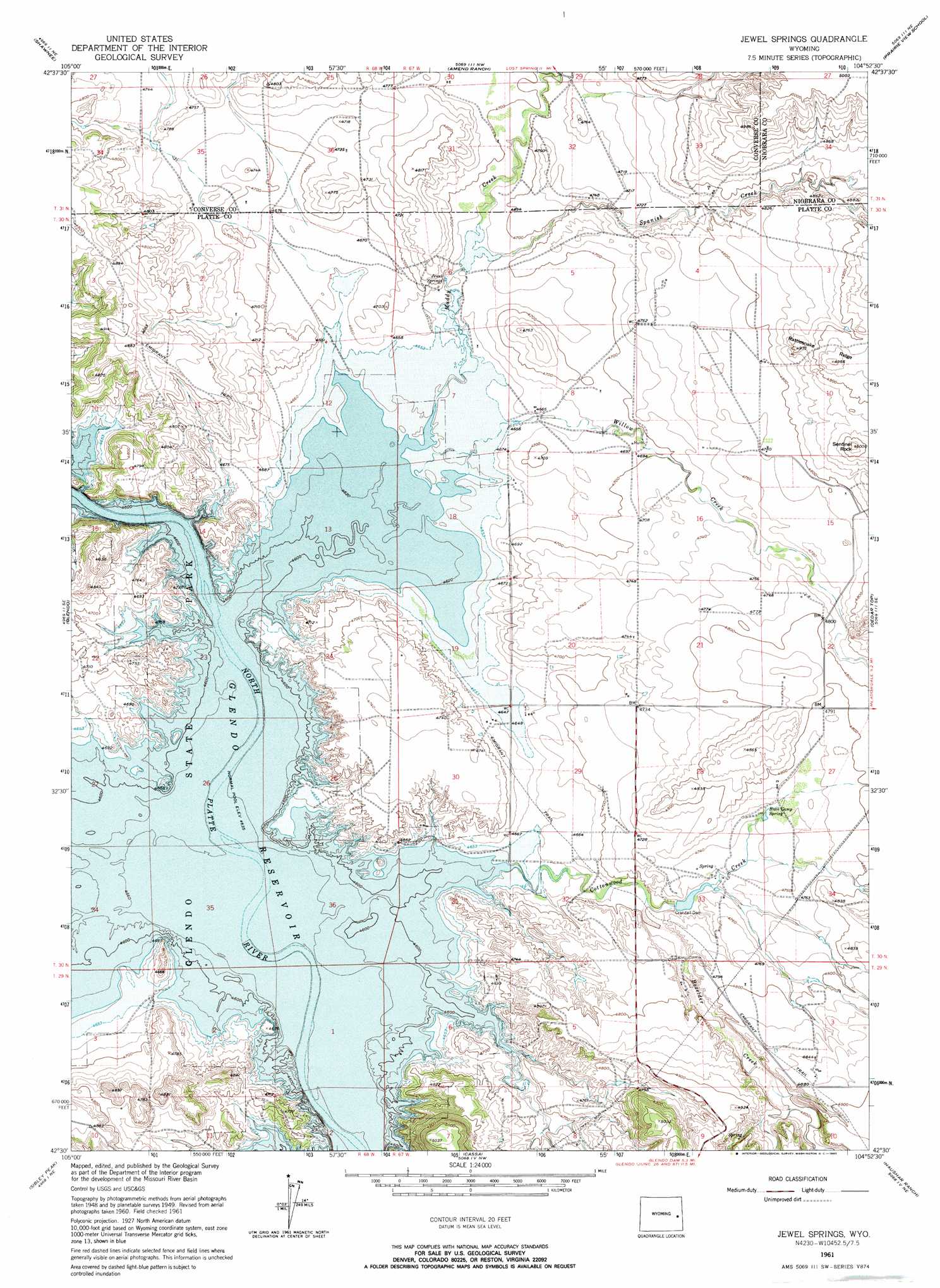
Jewel Springs Topo Map Wyoming
To zoom in, hover over the map of Jewel Springs
USGS Topo Quad 42104e8 - 1:24,000 scale
| Topo Map Name: | Jewel Springs |
| USGS Topo Quad ID: | 42104e8 |
| Print Size: | ca. 21 1/4" wide x 27" high |
| Southeast Coordinates: | 42.5° N latitude / 104.875° W longitude |
| Map Center Coordinates: | 42.5625° N latitude / 104.9375° W longitude |
| U.S. State: | WY |
| Filename: | o42104e8.jpg |
| Download Map JPG Image: | Jewel Springs topo map 1:24,000 scale |
| Map Type: | Topographic |
| Topo Series: | 7.5´ |
| Map Scale: | 1:24,000 |
| Source of Map Images: | United States Geological Survey (USGS) |
| Alternate Map Versions: |
Jewel Springs WY 1950 Download PDF Buy paper map Jewel Springs WY 1961, updated 1965 Download PDF Buy paper map Jewel Springs WY 2012 Download PDF Buy paper map Jewel Springs WY 2015 Download PDF Buy paper map |
1:24,000 Topo Quads surrounding Jewel Springs
Simpson Draw |
The Park |
Lost Springs |
Keeline |
Bills Creek |
Orin |
Shawnee |
Amend Ranch |
Prairie View School |
Lone Tree Hill |
Cedar Hill |
Glendo |
Jewel Springs |
Cedar Top |
Meadowdale |
Spring Creek |
Sibley Peak |
Cassa |
Haushar Ranch |
Hell Gap |
Cottonwood Falls |
Coleman Butte |
Herman Ranch |
Guernsey Reservoir |
Guernsey |
> Back to 42104e1 at 1:100,000 scale
> Back to 42104a1 at 1:250,000 scale
> Back to U.S. Topo Maps home
Jewel Springs topo map: Gazetteer
Jewel Springs: Dams
Crandall Dam elevation 1436m 4711′Muddy Number 1 Dam elevation 1422m 4665′
Jewel Springs: Parks
Glendo State Park elevation 1428m 4685′Jewel Springs: Reservoirs
Muddy Reservoir Number 1 elevation 1422m 4665′Jewel Springs: Ridges
Rattlesnake Ridge elevation 1500m 4921′Jewel Springs: Springs
Buck Camp Spring elevation 1451m 4760′Jewel Springs elevation 1428m 4685′
Jewel Springs: Streams
Boxelder Creek elevation 1431m 4694′Cottonwood Creek elevation 1419m 4655′
Muddy Creek elevation 1419m 4655′
Spanish Creek elevation 1428m 4685′
Willow Creek elevation 1419m 4655′
Jewel Springs: Summits
Sentinel Rock elevation 1503m 4931′Jewel Springs: Valleys
Morris Canyon elevation 1436m 4711′Jewel Springs digital topo map on disk
Buy this Jewel Springs topo map showing relief, roads, GPS coordinates and other geographical features, as a high-resolution digital map file on DVD:
Eastern Wyoming & Western South Dakota
Buy digital topo maps: Eastern Wyoming & Western South Dakota