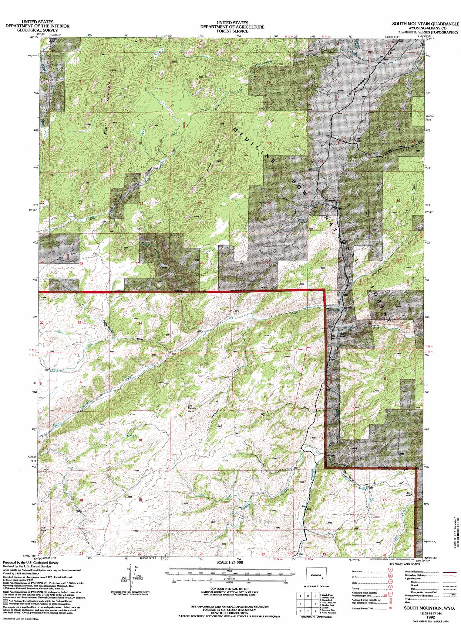
South Mountain Topo Map Wyoming
To zoom in, hover over the map of South Mountain
USGS Topo Quad 42105b4 - 1:24,000 scale
| Topo Map Name: | South Mountain |
| USGS Topo Quad ID: | 42105b4 |
| Print Size: | ca. 21 1/4" wide x 27" high |
| Southeast Coordinates: | 42.125° N latitude / 105.375° W longitude |
| Map Center Coordinates: | 42.1875° N latitude / 105.4375° W longitude |
| U.S. State: | WY |
| Filename: | o42105b4.jpg |
| Download Map JPG Image: | South Mountain topo map 1:24,000 scale |
| Map Type: | Topographic |
| Topo Series: | 7.5´ |
| Map Scale: | 1:24,000 |
| Source of Map Images: | United States Geological Survey (USGS) |
| Alternate Map Versions: |
South Mountain WY 1968, updated 1972 Download PDF Buy paper map South Mountain WY 1968, updated 1980 Download PDF Buy paper map South Mountain WY 1968, updated 1982 Download PDF Buy paper map South Mountain WY 1968, updated 1985 Download PDF Buy paper map South Mountain WY 1992, updated 1996 Download PDF Buy paper map South Mountain WY 2012 Download PDF Buy paper map South Mountain WY 2015 Download PDF Buy paper map |
| FStopo: | US Forest Service topo South Mountain is available: Download FStopo PDF Download FStopo TIF |
1:24,000 Topo Quads surrounding South Mountain
School Section Mountain |
Saddleback Mountain |
Braae |
Esterbrook |
Spring Creek |
Toltec |
Windy Peak |
Laramie Peak |
Harris Park |
Cottonwood Falls |
Cottonwood Creek |
Cow Creek Mountain |
South Mountain |
Fletcher Park |
Johnson Mountain |
Pinto Creek |
Garrett |
Davidson Flats |
Reese Mountain |
Hightower Sw |
Ayres Spring |
Dodge Ranch |
Bull Camp Peak |
Moonshine Peak |
Squaw Rock |
> Back to 42105a1 at 1:100,000 scale
> Back to 42104a1 at 1:250,000 scale
> Back to U.S. Topo Maps home
South Mountain topo map: Gazetteer
South Mountain: Dams
Parker Number 1 Dam elevation 2044m 6706′South Mountain: Flats
Cottonwood Park elevation 1975m 6479′South Mountain: Parks
Friend Park elevation 2263m 7424′South Mountain: Reservoirs
Parker Number 1 Reservoir elevation 2044m 6706′South Mountain: Streams
Arapaho Creek elevation 2095m 6873′Bear Creek elevation 1919m 6295′
Felix Creek elevation 1959m 6427′
Kloer Creek elevation 2160m 7086′
Rees Creek elevation 2018m 6620′
Reservoir Creek elevation 1978m 6489′
Siebolt Creek elevation 1958m 6423′
Sturgeon Creek elevation 1868m 6128′
South Mountain: Summits
Bear Head Mountain elevation 2480m 8136′Menter Knob elevation 2262m 7421′
South Mountain elevation 2664m 8740′
South Mountain: Valleys
Clark Draw elevation 1952m 6404′Menter Draw elevation 1953m 6407′
Merril Draw elevation 1912m 6272′
Murphy Canyon elevation 1895m 6217′
Rattlesnake Draw elevation 1944m 6377′
South Mountain digital topo map on disk
Buy this South Mountain topo map showing relief, roads, GPS coordinates and other geographical features, as a high-resolution digital map file on DVD:
Eastern Wyoming & Western South Dakota
Buy digital topo maps: Eastern Wyoming & Western South Dakota