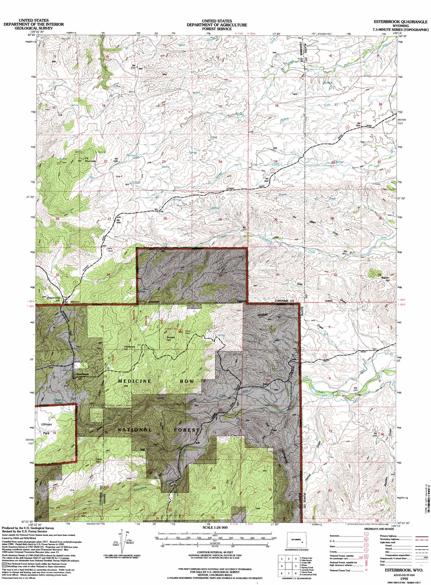
Esterbrook Topo Map Wyoming
To zoom in, hover over the map of Esterbrook
USGS Topo Quad 42105d3 - 1:24,000 scale
| Topo Map Name: | Esterbrook |
| USGS Topo Quad ID: | 42105d3 |
| Print Size: | ca. 21 1/4" wide x 27" high |
| Southeast Coordinates: | 42.375° N latitude / 105.25° W longitude |
| Map Center Coordinates: | 42.4375° N latitude / 105.3125° W longitude |
| U.S. State: | WY |
| Filename: | o42105d3.jpg |
| Download Map JPG Image: | Esterbrook topo map 1:24,000 scale |
| Map Type: | Topographic |
| Topo Series: | 7.5´ |
| Map Scale: | 1:24,000 |
| Source of Map Images: | United States Geological Survey (USGS) |
| Alternate Map Versions: |
Esterbrook WY 1985, updated 1985 Download PDF Buy paper map Esterbrook WY 1992, updated 1996 Download PDF Buy paper map Esterbrook WY 2012 Download PDF Buy paper map Esterbrook WY 2015 Download PDF Buy paper map |
| FStopo: | US Forest Service topo Esterbrook is available: Download FStopo PDF Download FStopo TIF |
1:24,000 Topo Quads surrounding Esterbrook
La Prele Reservoir |
Chalk Buttes |
Irvine |
Orin |
Shawnee |
Maneater Creek |
Poison Lake |
Dilts Ranch |
Cedar Hill |
Glendo |
Saddleback Mountain |
Braae |
Esterbrook |
Spring Creek |
Sibley Peak |
Windy Peak |
Laramie Peak |
Harris Park |
Cottonwood Falls |
Coleman Butte |
Cow Creek Mountain |
South Mountain |
Fletcher Park |
Johnson Mountain |
Lewis Flat |
> Back to 42105a1 at 1:100,000 scale
> Back to 42104a1 at 1:250,000 scale
> Back to U.S. Topo Maps home
Esterbrook topo map: Gazetteer
Esterbrook: Dams
Fred Dilts Number 4 Dam elevation 1875m 6151′Esterbrook: Populated Places
Esterbrook elevation 1986m 6515′Esterbrook: Reservoirs
Fred Dilts Reservoir Number 4 elevation 1875m 6151′Esterbrook: Springs
Cooper Spring elevation 1950m 6397′Esterbrook: Streams
Soldier Creek elevation 1738m 5702′Three Cripples Creek elevation 1619m 5311′
Esterbrook: Summits
Castle Rock elevation 1970m 6463′Elk Mountain elevation 1983m 6505′
Esterbrook Hill elevation 2064m 6771′
Prairie Dog Hill elevation 1950m 6397′
Reeder Hill elevation 1707m 5600′
Sunset Hill elevation 2019m 6624′
The Limestone elevation 1749m 5738′
Esterbrook: Valleys
Day Draw elevation 1820m 5971′Horse Draw elevation 1625m 5331′
Wildcat Draw elevation 1584m 5196′
Esterbrook digital topo map on disk
Buy this Esterbrook topo map showing relief, roads, GPS coordinates and other geographical features, as a high-resolution digital map file on DVD:
Eastern Wyoming & Western South Dakota
Buy digital topo maps: Eastern Wyoming & Western South Dakota