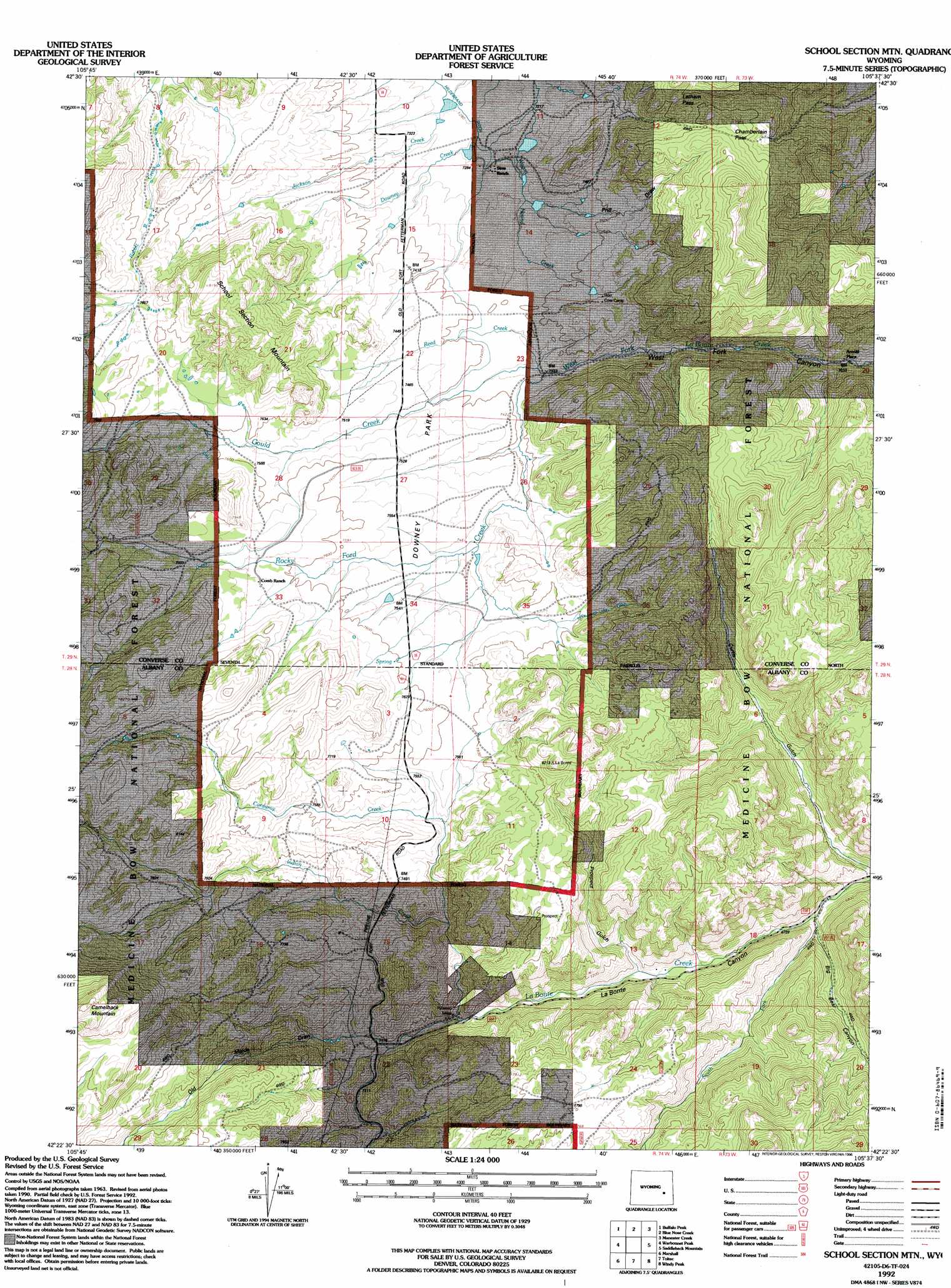
School Section Mountain Topo Map Wyoming
To zoom in, hover over the map of School Section Mountain
USGS Topo Quad 42105d6 - 1:24,000 scale
| Topo Map Name: | School Section Mountain |
| USGS Topo Quad ID: | 42105d6 |
| Print Size: | ca. 21 1/4" wide x 27" high |
| Southeast Coordinates: | 42.375° N latitude / 105.625° W longitude |
| Map Center Coordinates: | 42.4375° N latitude / 105.6875° W longitude |
| U.S. State: | WY |
| Filename: | o42105d6.jpg |
| Download Map JPG Image: | School Section Mountain topo map 1:24,000 scale |
| Map Type: | Topographic |
| Topo Series: | 7.5´ |
| Map Scale: | 1:24,000 |
| Source of Map Images: | United States Geological Survey (USGS) |
| Alternate Map Versions: |
School Section Mountain WY 1964, updated 1967 Download PDF Buy paper map School Section Mountain WY 1964, updated 1985 Download PDF Buy paper map School Section Mtn WY 1992, updated 1996 Download PDF Buy paper map School Section Mountain WY 2012 Download PDF Buy paper map School Section Mountain WY 2015 Download PDF Buy paper map |
| FStopo: | US Forest Service topo School Section Mountain is available: Download FStopo PDF Download FStopo TIF |
1:24,000 Topo Quads surrounding School Section Mountain
Protsmans Knob |
Root Creek |
Hermit Rock |
La Prele Reservoir |
Chalk Buttes |
Buck Peak |
Buffalo Peak |
Blue Nose Creek |
Maneater Creek |
Poison Lake |
Rock Creek |
Warbonnett Peak |
School Section Mountain |
Saddleback Mountain |
Braae |
Pass Creek |
Marshall |
Toltec |
Windy Peak |
Laramie Peak |
Boot Heel |
Rogers Creek |
Cottonwood Creek |
Cow Creek Mountain |
South Mountain |
> Back to 42105a1 at 1:100,000 scale
> Back to 42104a1 at 1:250,000 scale
> Back to U.S. Topo Maps home
School Section Mountain topo map: Gazetteer
School Section Mountain: Canals
Hildebrand Ditch elevation 2220m 7283′School Section Mountain: Dams
Wagonhound Dam elevation 2211m 7253′School Section Mountain: Flats
Downey Park elevation 2263m 7424′School Section Mountain: Gaps
Chamberlain Pass elevation 2403m 7883′Latham Pass elevation 2328m 7637′
School Section Mountain: Mines
Pyramid Mine elevation 2173m 7129′School Section Mountain: Reservoirs
Wagonhound Reservoir elevation 2211m 7253′School Section Mountain: Streams
Corduroy Creek elevation 2215m 7267′Downey Creek elevation 2206m 7237′
Gould Creek elevation 2233m 7326′
Indian Creek elevation 2159m 7083′
Reed Creek elevation 2233m 7326′
Rocky Ford Creek elevation 2233m 7326′
South Fork La Bonte Creek elevation 2047m 6715′
School Section Mountain: Summits
School Section Mountain elevation 2478m 8129′School Section Mountain: Valleys
Big Bear Canyon elevation 2066m 6778′Curtis Gulch elevation 2024m 6640′
Old Maids Draw elevation 2187m 7175′
Prill Draw elevation 2244m 7362′
Prospect Gulch elevation 2102m 6896′
West Fork Canyon elevation 2241m 7352′
School Section Mountain digital topo map on disk
Buy this School Section Mountain topo map showing relief, roads, GPS coordinates and other geographical features, as a high-resolution digital map file on DVD:
Eastern Wyoming & Western South Dakota
Buy digital topo maps: Eastern Wyoming & Western South Dakota