La Prele Reservoir Topo Map Wyoming
To zoom in, hover over the map of La Prele Reservoir
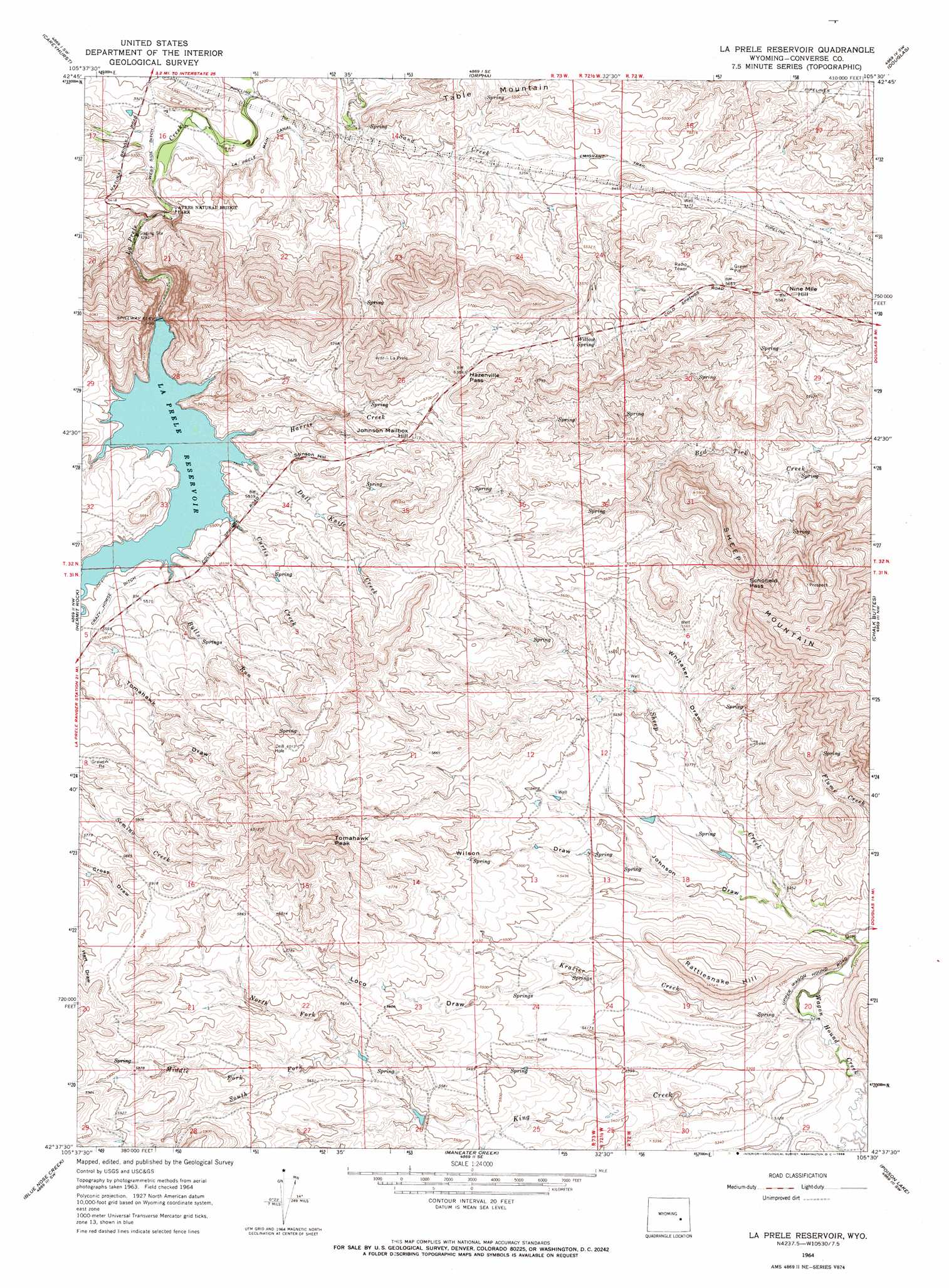
USGS Topo Quad 42105f5 - 1:24,000 scale
| Topo Map Name: | La Prele Reservoir |
| USGS Topo Quad ID: | 42105f5 |
| Print Size: | ca. 21 1/4" wide x 27" high |
| Southeast Coordinates: | 42.625° N latitude / 105.5° W longitude |
| Map Center Coordinates: | 42.6875° N latitude / 105.5625° W longitude |
| U.S. State: | WY |
| Filename: | o42105f5.jpg |
| Download Map JPG Image: | La Prele Reservoir topo map 1:24,000 scale |
| Map Type: | Topographic |
| Topo Series: | 7.5´ |
| Map Scale: | 1:24,000 |
| Source of Map Images: | United States Geological Survey (USGS) |
| Alternate Map Versions: |
La Prele Reservoir WY 1964, updated 1968 Download PDF Buy paper map La Prele Reservoir WY 2012 Download PDF Buy paper map La Prele Reservoir WY 2015 Download PDF Buy paper map |
1:24,000 Topo Quads surrounding La Prele Reservoir
Hylton Ranch |
Leuenberger Ranch |
Gilbert Lake |
Sundquist Ranch |
Clausen Ranch |
Glenrock |
Careyhurst |
Orpha |
Douglas |
Antelope Creek |
Root Creek |
Hermit Rock |
La Prele Reservoir |
Chalk Buttes |
Irvine |
Buffalo Peak |
Blue Nose Creek |
Maneater Creek |
Poison Lake |
Dilts Ranch |
Warbonnett Peak |
School Section Mountain |
Saddleback Mountain |
Braae |
Esterbrook |
> Back to 42105e1 at 1:100,000 scale
> Back to 42104a1 at 1:250,000 scale
> Back to U.S. Topo Maps home
La Prele Reservoir topo map: Gazetteer
La Prele Reservoir: Arches
Ayres Natural Bridge elevation 1632m 5354′La Prele Reservoir: Dams
Center Realty Reservoir Number 1 Dam elevation 1665m 5462′La Prele Dam elevation 1674m 5492′
Wilson Number 1 Dam elevation 1594m 5229′
La Prele Reservoir: Gaps
Hazenville Pass elevation 1756m 5761′Schofield Pass elevation 1733m 5685′
La Prele Reservoir: Reservoirs
Center Realty Reservoir Number 1 elevation 1665m 5462′La Prele Reservoir elevation 1663m 5456′
Wilson Number 1 Reservoir elevation 1594m 5229′
La Prele Reservoir: Slopes
Stinson Hill elevation 1734m 5688′La Prele Reservoir: Springs
Willow Spring elevation 1713m 5620′La Prele Reservoir: Streams
Buckshot Creek elevation 1675m 5495′Bulls Run elevation 1681m 5515′
Curtis Creek elevation 1679m 5508′
Dull Knife Creek elevation 1674m 5492′
Harris Creek elevation 1676m 5498′
King Creek elevation 1590m 5216′
Krazier Creek elevation 1590m 5216′
Middle Fork King Creek elevation 1719m 5639′
North Fork King Creek elevation 1696m 5564′
Sand Creek elevation 1585m 5200′
Sheep Creek elevation 1580m 5183′
South Fork King Creek elevation 1696m 5564′
La Prele Reservoir: Summits
Johnson Mailbox Hill elevation 1745m 5725′Nine Mile Hill elevation 1707m 5600′
Rattlesnake Hill elevation 1722m 5649′
Tomahawk Peak elevation 1867m 6125′
La Prele Reservoir: Valleys
Johnson Draw elevation 1595m 5232′Loco Draw elevation 1630m 5347′
Tomahawk Draw elevation 1688m 5538′
Whitaker Draw elevation 1630m 5347′
Wilson Draw elevation 1623m 5324′
La Prele Reservoir digital topo map on disk
Buy this La Prele Reservoir topo map showing relief, roads, GPS coordinates and other geographical features, as a high-resolution digital map file on DVD:
Eastern Wyoming & Western South Dakota
Buy digital topo maps: Eastern Wyoming & Western South Dakota