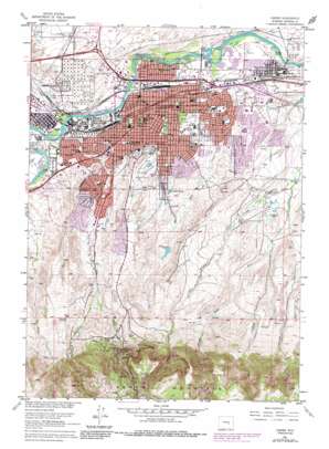
Casper Topo Map Wyoming
To zoom in, hover over the map of Casper
USGS Topo Quad 42106g3 - 1:24,000 scale
| Topo Map Name: | Casper |
| USGS Topo Quad ID: | 42106g3 |
| Print Size: | ca. 21 1/4" wide x 27" high |
| Southeast Coordinates: | 42.75° N latitude / 106.25° W longitude |
| Map Center Coordinates: | 42.8125° N latitude / 106.3125° W longitude |
| U.S. State: | WY |
| Filename: | o42106g3.jpg |
| Download Map JPG Image: | Casper topo map 1:24,000 scale |
| Map Type: | Topographic |
| Topo Series: | 7.5´ |
| Map Scale: | 1:24,000 |
| Source of Map Images: | United States Geological Survey (USGS) |
| Alternate Map Versions: |
Casper WY 1951, updated 1952 Download PDF Buy paper map Casper WY 1951, updated 1953 Download PDF Buy paper map Casper WY 1961, updated 1965 Download PDF Buy paper map Casper WY 1961, updated 1973 Download PDF Buy paper map Casper WY 1961, updated 1985 Download PDF Buy paper map Casper WY 2012 Download PDF Buy paper map Casper WY 2015 Download PDF Buy paper map |
1:24,000 Topo Quads surrounding Casper
> Back to 42106e1 at 1:100,000 scale
> Back to 42106a1 at 1:250,000 scale
> Back to U.S. Topo Maps home
Casper topo map: Gazetteer
Casper: Airports
True Heliport elevation 1559m 5114′Wyoming Medical Center Heliport elevation 1579m 5180′
Casper: Dams
Carroll Number 1 Dam elevation 1593m 5226′Carroll Number 2 Dam elevation 1580m 5183′
Duhling Dam elevation 1646m 5400′
East Fork Wolf Creek Dam elevation 1665m 5462′
Evansville Storage Dam elevation 1897m 6223′
Katy Dam elevation 1638m 5374′
Miller Dam elevation 1717m 5633′
Sage Creek Dam elevation 1687m 5534′
Spicer Upper Dam elevation 1689m 5541′
Casper: Falls
Garden Creek Waterfall elevation 1958m 6423′Casper: Mines
Casper Concrete Pit elevation 1555m 5101′Hidebrand Pit elevation 1593m 5226′
Kaycee Clay Mine elevation 1610m 5282′
Kaycee Mine elevation 1638m 5374′
Koch Deposit Number Two elevation 2036m 6679′
Midwest-Thoeming and Wakem Mine elevation 1562m 5124′
Rim Rock Ranch Pit elevation 2003m 6571′
Casper: Parks
Eastdale Park elevation 1565m 5134′Fort Casper Historical Grounds elevation 1561m 5121′
Hospital Park elevation 1572m 5157′
Huber Park elevation 1581m 5187′
North Casper Park elevation 1555m 5101′
Rotary Park elevation 1911m 6269′
Washington Park elevation 1592m 5223′
Westwood Park elevation 1566m 5137′
Casper: Populated Places
Allendale elevation 1634m 5360′Casper elevation 1560m 5118′
Evansville elevation 1562m 5124′
Midwest Heights elevation 1585m 5200′
Mills elevation 1562m 5124′
Thorndale Acres elevation 1620m 5314′
Casper: Reservoirs
Carroll Number 1 Reservoir elevation 1593m 5226′Carroll Number 2 Reservoir elevation 1580m 5183′
Casper Reservoir elevation 1625m 5331′
Duhling Reservoir elevation 1646m 5400′
East Fork Wolf Creek Reservoir elevation 1665m 5462′
Evansville Storage Reservoir elevation 1897m 6223′
Katy Reservoir elevation 1638m 5374′
Miller Reservoir elevation 1717m 5633′
Sage Creek Reservoir elevation 1687m 5534′
Spicer Upper Reservoir elevation 1689m 5541′
Casper: Springs
Hillcrest Spring elevation 1837m 6026′Casper: Streams
Casper Creek elevation 1560m 5118′East Fork Elkhorn Creek elevation 1601m 5252′
Garden Creek elevation 1561m 5121′
Katy Creek elevation 1653m 5423′
Middle Fork Elkhorn Creek elevation 1742m 5715′
Sage Creek elevation 1555m 5101′
West Fork Garden Creek elevation 1732m 5682′
Casper: Summits
Casper Mountain elevation 2390m 7841′Scott Hill elevation 1616m 5301′
Casper digital topo map on disk
Buy this Casper topo map showing relief, roads, GPS coordinates and other geographical features, as a high-resolution digital map file on DVD:
Eastern Wyoming & Western South Dakota
Buy digital topo maps: Eastern Wyoming & Western South Dakota


