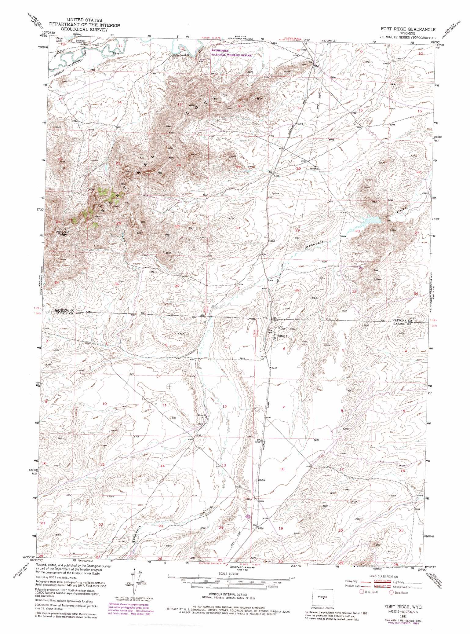
Fort Ridge Topo Map Wyoming
To zoom in, hover over the map of Fort Ridge
USGS Topo Quad 42107d1 - 1:24,000 scale
| Topo Map Name: | Fort Ridge |
| USGS Topo Quad ID: | 42107d1 |
| Print Size: | ca. 21 1/4" wide x 27" high |
| Southeast Coordinates: | 42.375° N latitude / 107° W longitude |
| Map Center Coordinates: | 42.4375° N latitude / 107.0625° W longitude |
| U.S. State: | WY |
| Filename: | o42107d1.jpg |
| Download Map JPG Image: | Fort Ridge topo map 1:24,000 scale |
| Map Type: | Topographic |
| Topo Series: | 7.5´ |
| Map Scale: | 1:24,000 |
| Source of Map Images: | United States Geological Survey (USGS) |
| Alternate Map Versions: |
Fort Ridge WY 1951, updated 1953 Download PDF Buy paper map Fort Ridge WY 1951, updated 1973 Download PDF Buy paper map Fort Ridge WY 1951, updated 1981 Download PDF Buy paper map Fort Ridge WY 2012 Download PDF Buy paper map Fort Ridge WY 2015 Download PDF Buy paper map |
1:24,000 Topo Quads surrounding Fort Ridge
Barlow Gap |
Saddle Rock |
Horse Creek Springs |
Mccleary Reservoir |
Benton Basin Ne |
Miller Spring |
Beulah Belle Lake |
Sanford Ranch |
Benton Basin Sw |
Benton Basin |
Savage Peak |
Independence Rock |
Fort Ridge |
Pathfinder Reservoir Nw |
Pathfinder Dam |
Youngs Pass |
Spanish Mine |
Buzzard Ranch |
Pathfinder Reservoir Sw |
Leo |
Lamont Ne |
Ferris |
Bradley Peak |
Seminoe Dam |
Seminoe Dam Ne |
> Back to 42107a1 at 1:100,000 scale
> Back to 42106a1 at 1:250,000 scale
> Back to U.S. Topo Maps home
Fort Ridge topo map: Gazetteer
Fort Ridge: Dams
Annis Dam elevation 1833m 6013′Fort Ridge: Reservoirs
Annis Reservoir elevation 1833m 6013′Fort Ridge: Ridges
Sentinel Rocks elevation 2169m 7116′Fort Ridge: Streams
East Arkansas Creek elevation 1891m 6204′Fort Ridge: Summits
Fort Ridge elevation 2186m 7171′Fort Ridge digital topo map on disk
Buy this Fort Ridge topo map showing relief, roads, GPS coordinates and other geographical features, as a high-resolution digital map file on DVD:
Eastern Wyoming & Western South Dakota
Buy digital topo maps: Eastern Wyoming & Western South Dakota