Gas Hills Topo Map Wyoming
To zoom in, hover over the map of Gas Hills
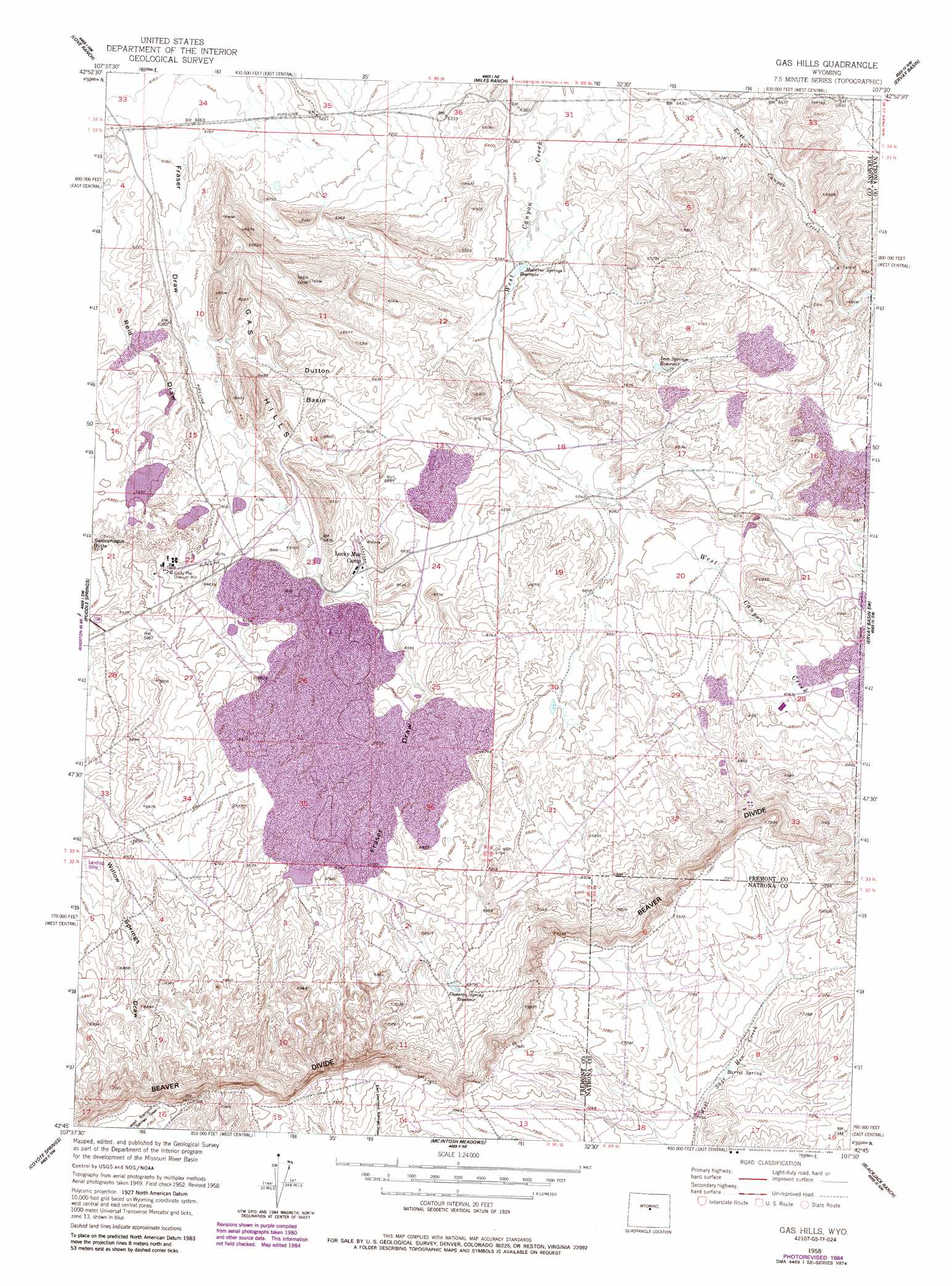
USGS Topo Quad 42107g5 - 1:24,000 scale
| Topo Map Name: | Gas Hills |
| USGS Topo Quad ID: | 42107g5 |
| Print Size: | ca. 21 1/4" wide x 27" high |
| Southeast Coordinates: | 42.75° N latitude / 107.5° W longitude |
| Map Center Coordinates: | 42.8125° N latitude / 107.5625° W longitude |
| U.S. State: | WY |
| Filename: | o42107g5.jpg |
| Download Map JPG Image: | Gas Hills topo map 1:24,000 scale |
| Map Type: | Topographic |
| Topo Series: | 7.5´ |
| Map Scale: | 1:24,000 |
| Source of Map Images: | United States Geological Survey (USGS) |
| Alternate Map Versions: |
Gas Hills WY 1952, updated 1953 Download PDF Buy paper map Gas Hills WY 1952, updated 1956 Download PDF Buy paper map Gas Hills WY 1958, updated 1959 Download PDF Buy paper map Gas Hills WY 1958, updated 1975 Download PDF Buy paper map Gas Hills WY 1958, updated 1985 Download PDF Buy paper map Gas Hills WY 2012 Download PDF Buy paper map Gas Hills WY 2015 Download PDF Buy paper map |
1:24,000 Topo Quads surrounding Gas Hills
Squaw Butte |
Seventy One Reservoir |
Moneta Se |
Arminto Sw |
Hiland |
Butte Well |
Love Ranch |
Miles Ranch |
Ervay Basin |
Mcrae Gap |
Rongis Reservoir Se |
Puddle Springs |
Gas Hills |
Ervay Basin Sw |
Garfield Peak |
Muskrat Basin |
Coyote Springs |
Mcintosh Meadows |
Blackjack Ranch |
Barlow Gap |
Stampede Meadow |
Black Rock Gap |
Lankin Dome |
Lone Mountain |
Miller Spring |
> Back to 42107e1 at 1:100,000 scale
> Back to 42106a1 at 1:250,000 scale
> Back to U.S. Topo Maps home
Gas Hills topo map: Gazetteer
Gas Hills: Basins
Dutton Basin elevation 1975m 6479′Gas Hills: Mines
Beaver Rim Annex Mine elevation 2079m 6820′Big Bull Number Three Mine elevation 1983m 6505′
Bill Eykamp Number Two Mine elevation 2023m 6637′
Blue Buck Number One Number Mine elevation 2092m 6863′
Bobcat Group Mine elevation 1991m 6532′
Bobcat Mine elevation 2019m 6624′
Cannel Number Nine Mine elevation 1998m 6555′
Clark Number Three Mine elevation 1999m 6558′
Clark Number Two Mine elevation 1957m 6420′
D and M Number One Mine elevation 2080m 6824′
Deseret Number One Mine elevation 2080m 6824′
E Pits elevation 2055m 6742′
Fanny May Mine elevation 2022m 6633′
Frasier-Lamac Mine elevation 2024m 6640′
Gas Hills Project Mine elevation 1919m 6295′
George Mine elevation 1982m 6502′
Hayes Number Seven Mine elevation 2012m 6601′
Hylite Number Three Mine elevation 1986m 6515′
Jay Z Mine elevation 1983m 6505′
John Jay Mine elevation 1992m 6535′
John-C Mine elevation 1995m 6545′
JSJ Number One Mine elevation 2023m 6637′
Last Chance Mine elevation 2059m 6755′
Lucky Mac Mine elevation 1999m 6558′
Lucky Mac Number Fifteen Mine elevation 1958m 6423′
Lucky Mac Number Sixteen Mine elevation 1958m 6423′
M F and K Group Number Fifteen Mine elevation 2092m 6863′
M F and K Group Number Seven Mine elevation 2092m 6863′
Mountain Mesa U Pit elevation 2092m 6863′
Noble Number Seven Mine elevation 1997m 6551′
Noble Number Thirty Mine elevation 1997m 6551′
PCH Number Sixteen Mine elevation 2123m 6965′
Rainbow Number One Mine elevation 2080m 6824′
Ray Number Six Mine elevation 2059m 6755′
Red Hen Number Sixteen Mine elevation 2059m 6755′
Red Horse Number Three Mine elevation 2096m 6876′
Rim Mine elevation 2068m 6784′
Rim Number Four Mine elevation 2031m 6663′
Rox Mine elevation 2081m 6827′
S E Erickson Pit Number Two elevation 2078m 6817′
Sailboat Number One Mine elevation 1986m 6515′
School Section Mine elevation 2067m 6781′
Silver Spider Number Two Mine elevation 2023m 6637′
Stan Number Nine Mine elevation 2025m 6643′
Stan Number One Mine elevation 2002m 6568′
Stan Number Seven Mine elevation 2022m 6633′
Stan Number Three Mine elevation 2018m 6620′
Thunderbird Number One Mine elevation 2033m 6669′
U Mine elevation 2243m 7358′
Uranium Point Number Nine Mine elevation 2147m 7043′
Veca Mine elevation 2081m 6827′
Wind River Group Mine elevation 2021m 6630′
Wing Number One Mine elevation 1991m 6532′
Yellowbuck Mine elevation 2026m 6646′
Gas Hills: Ranges
Gas Hills elevation 1942m 6371′Gas Hills: Reservoirs
Cameron Spring Reservoir elevation 2116m 6942′Canyon Creek Reservoir elevation 2072m 6797′
Iron Springs Reservoir elevation 2007m 6584′
Medicine Springs Reservoir elevation 1948m 6391′
Gas Hills: Springs
Barrel Spring elevation 2193m 7194′Gas Hills digital topo map on disk
Buy this Gas Hills topo map showing relief, roads, GPS coordinates and other geographical features, as a high-resolution digital map file on DVD:
Eastern Wyoming & Western South Dakota
Buy digital topo maps: Eastern Wyoming & Western South Dakota