Fossil Hill Topo Map Wyoming
To zoom in, hover over the map of Fossil Hill
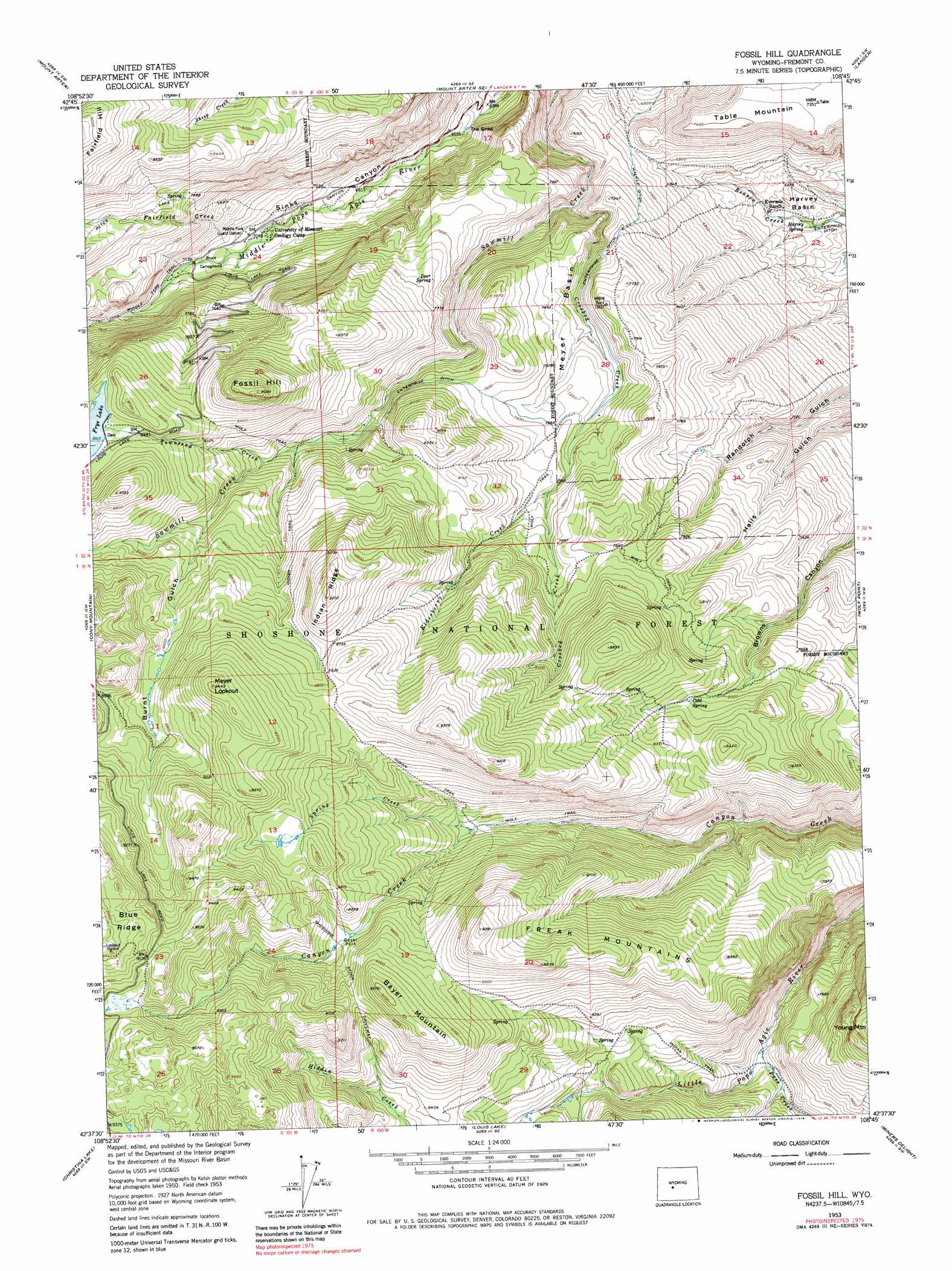
USGS Topo Quad 42108f7 - 1:24,000 scale
| Topo Map Name: | Fossil Hill |
| USGS Topo Quad ID: | 42108f7 |
| Print Size: | ca. 21 1/4" wide x 27" high |
| Southeast Coordinates: | 42.625° N latitude / 108.75° W longitude |
| Map Center Coordinates: | 42.6875° N latitude / 108.8125° W longitude |
| U.S. State: | WY |
| Filename: | o42108f7.jpg |
| Download Map JPG Image: | Fossil Hill topo map 1:24,000 scale |
| Map Type: | Topographic |
| Topo Series: | 7.5´ |
| Map Scale: | 1:24,000 |
| Source of Map Images: | United States Geological Survey (USGS) |
| Alternate Map Versions: |
Fossil Hill WY 1953, updated 1955 Download PDF Buy paper map Fossil Hill WY 1953, updated 1963 Download PDF Buy paper map Fossil Hill WY 1953, updated 1973 Download PDF Buy paper map Fossil Hill WY 1953, updated 1979 Download PDF Buy paper map Fossil Hill WY 1991, updated 1997 Download PDF Buy paper map Fossil Hill WY 2012 Download PDF Buy paper map Fossil Hill WY 2015 Download PDF Buy paper map |
| FStopo: | US Forest Service topo Fossil Hill is available: Download FStopo PDF Download FStopo TIF |
1:24,000 Topo Quads surrounding Fossil Hill
Moccasin Lake |
Wind River |
Ray Lake |
Lander Nw |
Hudson |
Dickinson Park |
Mount Arter |
Mount Arter Se |
Lander |
Lander Se |
Sweetwater Gap |
Cony Mountain |
Fossil Hill |
Wolf Point |
Weiser Pass |
Sweetwater Needles |
Christina Lake |
Louis Lake |
Miners Delight |
Gravel Spring |
Halls Meadow Spring |
Anderson Ridge |
South Pass City |
Atlantic City |
Radium Springs |
> Back to 42108e1 at 1:100,000 scale
> Back to 42108a1 at 1:250,000 scale
> Back to U.S. Topo Maps home
Fossil Hill topo map: Gazetteer
Fossil Hill: Basins
Meyer Basin elevation 2288m 7506′Fossil Hill: Canals
Enterprise Ditch elevation 2243m 7358′Walker Ditch elevation 2086m 6843′
Fossil Hill: Dams
Enterprise Dam elevation 2620m 8595′Fossil Hill: Flats
Bayer Park elevation 2616m 8582′Fossil Hill: Lakes
The Sinks elevation 1983m 6505′Fossil Hill: Mines
Table Mountain Number One Mine elevation 2268m 7440′Table Mountain Number Two Mine elevation 2315m 7595′
Fossil Hill: Ranges
Freak Mountains elevation 2701m 8861′Fossil Hill: Reservoirs
Enterprise Reservoir elevation 2620m 8595′Frye Lake elevation 2589m 8494′
Fossil Hill: Ridges
Indian Ridge elevation 2805m 9202′Fossil Hill: Springs
Cold Spring elevation 2454m 8051′Deer Spring elevation 2360m 7742′
Harvey Spring elevation 1923m 6309′
Fossil Hill: Streams
Crooked Creek elevation 2110m 6922′Elderberry Creek elevation 2329m 7641′
Fairfield Creek elevation 2155m 7070′
Pass Creek elevation 2195m 7201′
Spring Creek elevation 2429m 7969′
Townsend Creek elevation 2396m 7860′
Fossil Hill: Summits
Bayer Mountain elevation 2809m 9215′Fossil Hill elevation 2770m 9087′
Meyer Lookout elevation 2880m 9448′
Fossil Hill: Trails
Indian Trail elevation 2653m 8704′Wolf Trail elevation 2396m 7860′
Fossil Hill: Valleys
Burnt Gulch elevation 2493m 8179′Fossil Hill digital topo map on disk
Buy this Fossil Hill topo map showing relief, roads, GPS coordinates and other geographical features, as a high-resolution digital map file on DVD: