Cony Mountain Topo Map Wyoming
To zoom in, hover over the map of Cony Mountain
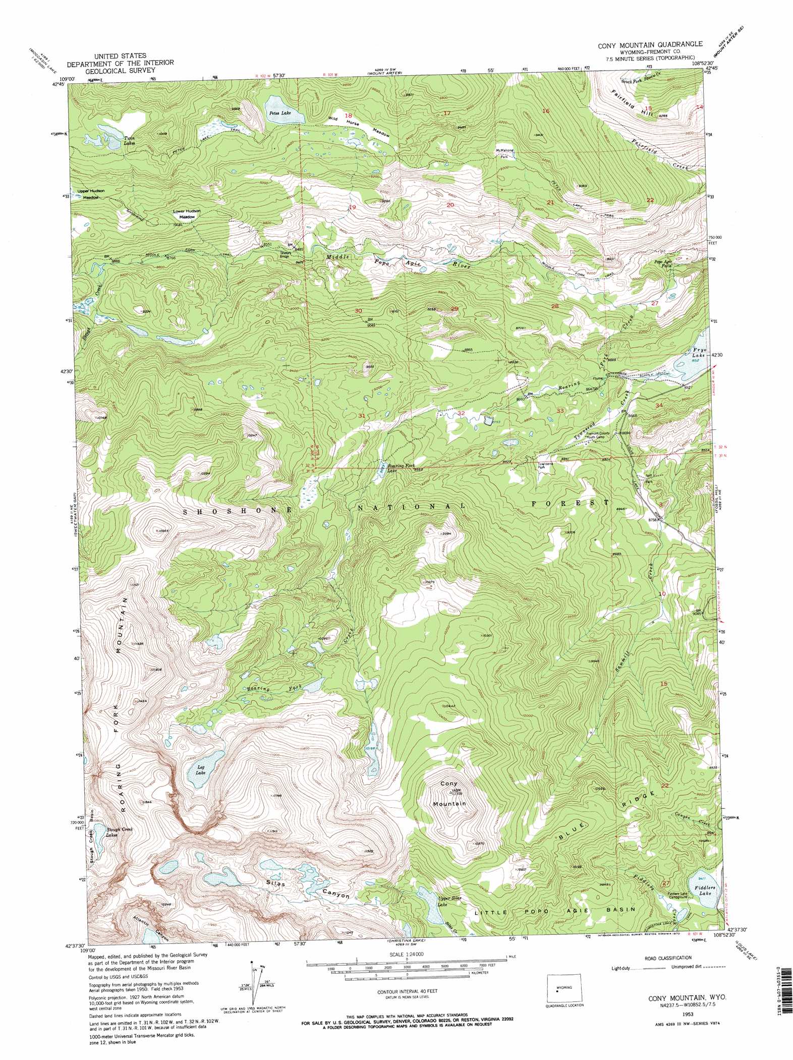
USGS Topo Quad 42108f8 - 1:24,000 scale
| Topo Map Name: | Cony Mountain |
| USGS Topo Quad ID: | 42108f8 |
| Print Size: | ca. 21 1/4" wide x 27" high |
| Southeast Coordinates: | 42.625° N latitude / 108.875° W longitude |
| Map Center Coordinates: | 42.6875° N latitude / 108.9375° W longitude |
| U.S. State: | WY |
| Filename: | o42108f8.jpg |
| Download Map JPG Image: | Cony Mountain topo map 1:24,000 scale |
| Map Type: | Topographic |
| Topo Series: | 7.5´ |
| Map Scale: | 1:24,000 |
| Source of Map Images: | United States Geological Survey (USGS) |
| Alternate Map Versions: |
Cony Mountain WY 1953, updated 1955 Download PDF Buy paper map Cony Mountain WY 1953, updated 1963 Download PDF Buy paper map Cony Mountain WY 1953, updated 1970 Download PDF Buy paper map Cony Mountain WY 1953, updated 1970 Download PDF Buy paper map Cony Mountain WY 1991, updated 1997 Download PDF Buy paper map Cony Mountain WY 1991, updated 1997 Download PDF Buy paper map Cony Mountain WY 2012 Download PDF Buy paper map Cony Mountain WY 2015 Download PDF Buy paper map |
| FStopo: | US Forest Service topo Cony Mountain is available: Download FStopo PDF Download FStopo TIF |
1:24,000 Topo Quads surrounding Cony Mountain
Washakie Park |
Moccasin Lake |
Wind River |
Ray Lake |
Lander Nw |
Lizard Head Peak |
Dickinson Park |
Mount Arter |
Mount Arter Se |
Lander |
Temple Peak |
Sweetwater Gap |
Cony Mountain |
Fossil Hill |
Wolf Point |
Jensen Meadows |
Sweetwater Needles |
Christina Lake |
Louis Lake |
Miners Delight |
Prospect Mountains |
Halls Meadow Spring |
Anderson Ridge |
South Pass City |
Atlantic City |
> Back to 42108e1 at 1:100,000 scale
> Back to 42108a1 at 1:250,000 scale
> Back to U.S. Topo Maps home
Cony Mountain topo map: Gazetteer
Cony Mountain: Bridges
Sheep Bridge elevation 2590m 8497′Cony Mountain: Canals
Enterprise Supply Ditch elevation 2609m 8559′Cony Mountain: Dams
Worten Meadow Dam elevation 2656m 8713′Cony Mountain: Falls
Popo Agie Falls elevation 2359m 7739′Cony Mountain: Flats
Deer Park elevation 2705m 8874′Lower Hudson Meadow elevation 2763m 9064′
McMahone Park elevation 2750m 9022′
Neff Park elevation 2667m 8750′
Townsend Park elevation 2679m 8789′
Wild Horse Meadow elevation 2876m 9435′
Cony Mountain: Lakes
Boulder Lake elevation 3091m 10141′Fiddlers Lake elevation 2872m 9422′
Island Lake elevation 3224m 10577′
Leg Lake elevation 3202m 10505′
Petes Lake elevation 2884m 9461′
Roaring Fork Lake elevation 2751m 9025′
Thumb Lake elevation 3349m 10987′
Twin Lakes elevation 2970m 9744′
Twin Lakes elevation 2751m 9025′
Upper Silas Lake elevation 3079m 10101′
Cony Mountain: Reservoirs
Worten Meadow Reservoir elevation 2656m 8713′Worthen Meadow Reservoir elevation 2690m 8825′
Cony Mountain: Ridges
Blue Ridge elevation 3090m 10137′Cony Mountain: Streams
Roaring Fork Creek elevation 2443m 8015′Stough Creek elevation 2713m 8900′
Cony Mountain: Summits
Cony Mountain elevation 3383m 11099′Fairfield Hill elevation 2827m 9274′
Cony Mountain: Trails
Cold Spring Trail elevation 2711m 8894′Middle Fork Trail elevation 2481m 8139′
Petes Lake Trail elevation 2867m 9406′
Cony Mountain: Valleys
Silas Canyon elevation 3133m 10278′Cony Mountain digital topo map on disk
Buy this Cony Mountain topo map showing relief, roads, GPS coordinates and other geographical features, as a high-resolution digital map file on DVD: