Ray Lake Topo Map Wyoming
To zoom in, hover over the map of Ray Lake
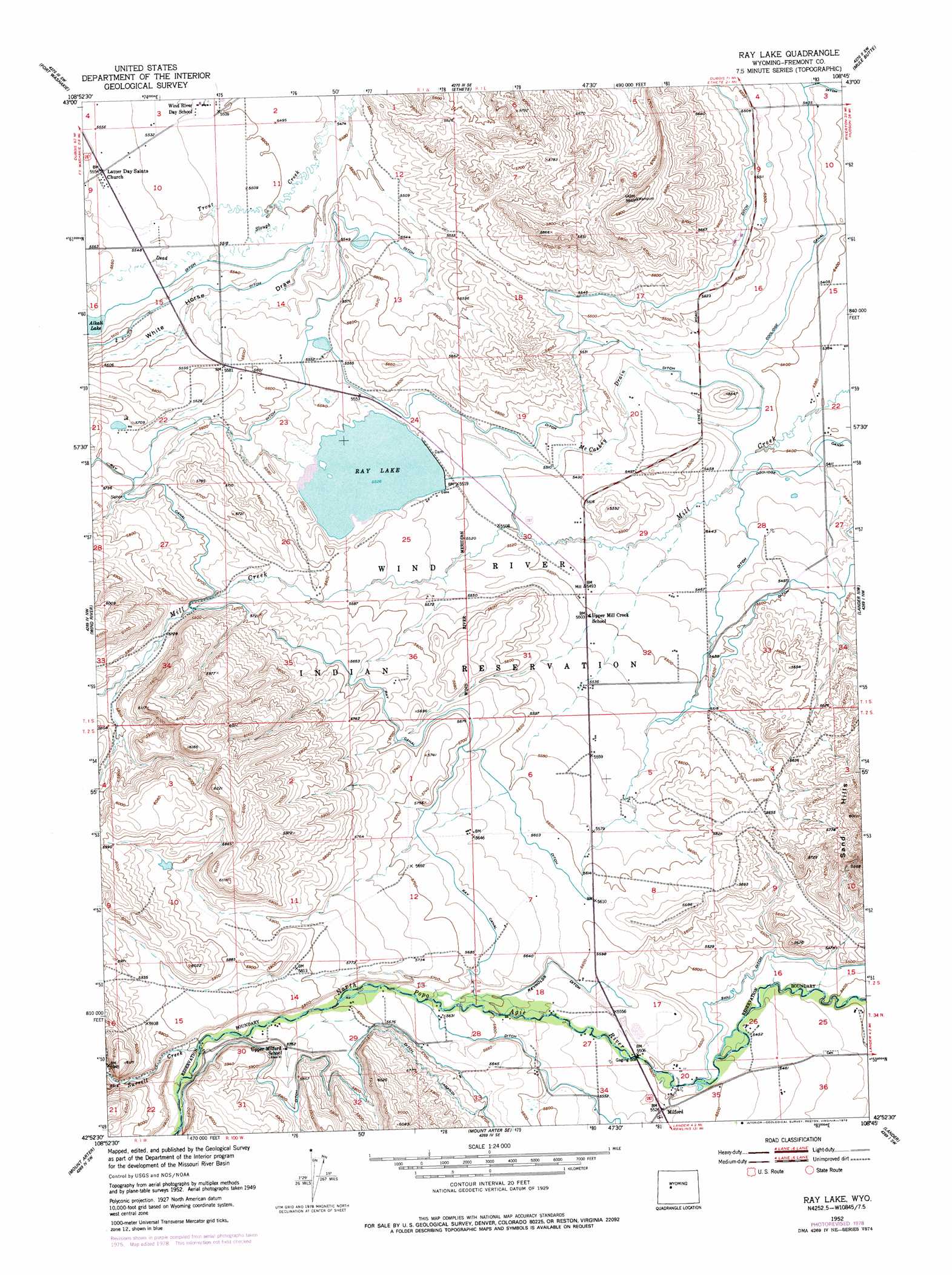
USGS Topo Quad 42108h7 - 1:24,000 scale
| Topo Map Name: | Ray Lake |
| USGS Topo Quad ID: | 42108h7 |
| Print Size: | ca. 21 1/4" wide x 27" high |
| Southeast Coordinates: | 42.875° N latitude / 108.75° W longitude |
| Map Center Coordinates: | 42.9375° N latitude / 108.8125° W longitude |
| U.S. State: | WY |
| Filename: | o42108h7.jpg |
| Download Map JPG Image: | Ray Lake topo map 1:24,000 scale |
| Map Type: | Topographic |
| Topo Series: | 7.5´ |
| Map Scale: | 1:24,000 |
| Source of Map Images: | United States Geological Survey (USGS) |
| Alternate Map Versions: |
Ray Lake WY 1952, updated 1954 Download PDF Buy paper map Ray Lake WY 1952, updated 1973 Download PDF Buy paper map Ray Lake WY 1952, updated 1979 Download PDF Buy paper map Ray Lake WY 2012 Download PDF Buy paper map Ray Lake WY 2015 Download PDF Buy paper map |
1:24,000 Topo Quads surrounding Ray Lake
Bull Lake East |
Argo Butte |
Morton |
Pavillion |
Ocean Lake |
Wise Flat |
Fort Washakie |
Ethete |
Mule Butte |
Pavillion Se |
Moccasin Lake |
Wind River |
Ray Lake |
Lander Nw |
Hudson |
Dickinson Park |
Mount Arter |
Mount Arter Se |
Lander |
Lander Se |
Sweetwater Gap |
Cony Mountain |
Fossil Hill |
Wolf Point |
Weiser Pass |
> Back to 42108e1 at 1:100,000 scale
> Back to 42108a1 at 1:250,000 scale
> Back to U.S. Topo Maps home
Ray Lake topo map: Gazetteer
Ray Lake: Canals
Coolidge Canal elevation 1655m 5429′Ray Canal elevation 1732m 5682′
Ray Lake: Dams
Ray Dam elevation 1685m 5528′Ray Lake: Mines
Wind River Mountain Front Number Six Mine elevation 1737m 5698′Wind River Mountain Front Number Three Mine elevation 1804m 5918′
Ray Lake: Populated Places
Boulder Flats elevation 1703m 5587′Milford elevation 1685m 5528′
Ray Lake: Reservoirs
Ray Lake elevation 1685m 5528′Ray Reservoir elevation 1685m 5528′
Ray Lake: Streams
Dead Horse Slough elevation 1677m 5501′McCaskey Drain elevation 1652m 5419′
Surrell Creek elevation 1763m 5784′
Ray Lake: Valleys
White Horse Draw elevation 1672m 5485′Ray Lake digital topo map on disk
Buy this Ray Lake topo map showing relief, roads, GPS coordinates and other geographical features, as a high-resolution digital map file on DVD: