Fontenelle Basin Topo Map Wyoming
To zoom in, hover over the map of Fontenelle Basin
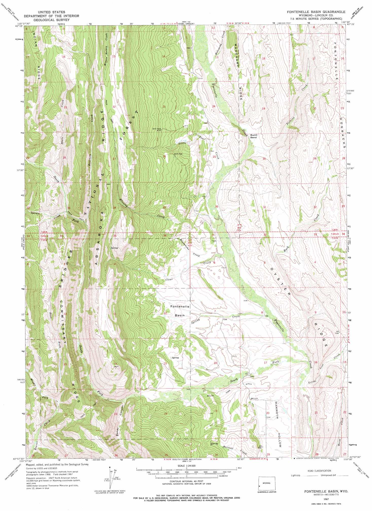
USGS Topo Quad 42110b5 - 1:24,000 scale
| Topo Map Name: | Fontenelle Basin |
| USGS Topo Quad ID: | 42110b5 |
| Print Size: | ca. 21 1/4" wide x 27" high |
| Southeast Coordinates: | 42.125° N latitude / 110.5° W longitude |
| Map Center Coordinates: | 42.1875° N latitude / 110.5625° W longitude |
| U.S. State: | WY |
| Filename: | o42110b5.jpg |
| Download Map JPG Image: | Fontenelle Basin topo map 1:24,000 scale |
| Map Type: | Topographic |
| Topo Series: | 7.5´ |
| Map Scale: | 1:24,000 |
| Source of Map Images: | United States Geological Survey (USGS) |
| Alternate Map Versions: |
Fontenelle Basin WY 1967, updated 1971 Download PDF Buy paper map Fontenelle Basin WY 1967, updated 1978 Download PDF Buy paper map Fontenelle Basin WY 2012 Download PDF Buy paper map Fontenelle Basin WY 2015 Download PDF Buy paper map |
| FStopo: | US Forest Service topo Fontenelle Basin is available: Download FStopo PDF Download FStopo TIF |
1:24,000 Topo Quads surrounding Fontenelle Basin
Porcupine Creek |
Graham Peak |
Mount Thompson |
Pine Grove Ridge |
Cretaceous Mountain |
Big Park |
Devils Hole Creek |
Coal Creek |
Lake Mountain |
The Hogsback |
Nugent Park |
Pole Creek |
Fontenelle Basin |
Fort Hill |
Red Gap |
Sublette Canyon |
Wilkinson Creek |
South Fork Mountain |
Fontenelle Gap |
The Palisades |
The Rock Slide |
Kemmerer Reservoir |
Sublet |
Round Mountain |
Graham Reservoir |
> Back to 42110a1 at 1:100,000 scale
> Back to 42110a1 at 1:250,000 scale
> Back to U.S. Topo Maps home
Fontenelle Basin topo map: Gazetteer
Fontenelle Basin: Basins
Fontenelle Basin elevation 2248m 7375′Fontenelle Basin: Canals
South Fork Ditch elevation 2266m 7434′Fontenelle Basin: Flats
Burnt Bend elevation 2302m 7552′Fontenelle Basin: Ridges
Commissary Ridge elevation 2571m 8435′Fontenelle Hogbacks elevation 2598m 8523′
Fontenelle Basin: Streams
Bearhole Creek elevation 2443m 8015′Bluejay Creek elevation 2265m 7431′
Clear Creek elevation 2237m 7339′
East Fork Beaver Creek elevation 2389m 7837′
Krall Spring Creek elevation 2252m 7388′
Little Bear Creek elevation 2276m 7467′
Little Coal Creek elevation 2204m 7230′
Mahogany Creek elevation 2339m 7673′
Middle Fork Beaver Creek elevation 2399m 7870′
Minnehaha Creek elevation 2254m 7395′
Perkins Creek elevation 2292m 7519′
Rock Creek elevation 2213m 7260′
Shale Creek elevation 2485m 8152′
South Fork Fontenelle Creek elevation 2205m 7234′
Spring Creek elevation 2224m 7296′
Spruce Creek elevation 2451m 8041′
Fontenelle Basin: Valleys
Boney Canyon elevation 2303m 7555′Fontenelle Basin digital topo map on disk
Buy this Fontenelle Basin topo map showing relief, roads, GPS coordinates and other geographical features, as a high-resolution digital map file on DVD: