Porcupine Creek Topo Map Wyoming
To zoom in, hover over the map of Porcupine Creek
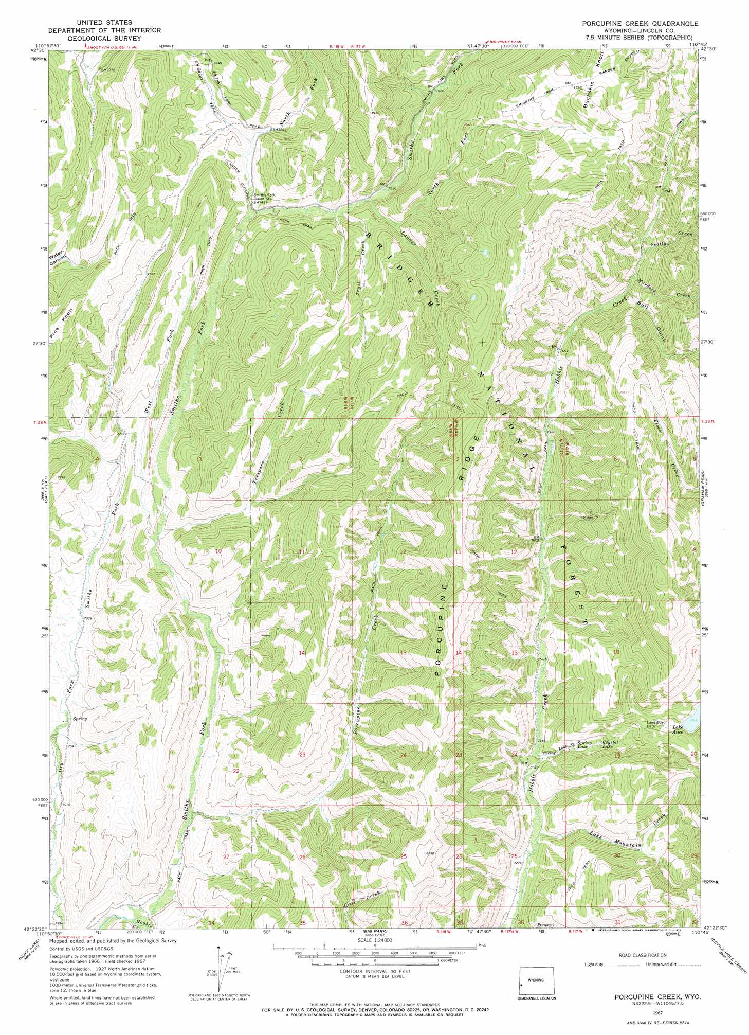
USGS Topo Quad 42110d7 - 1:24,000 scale
| Topo Map Name: | Porcupine Creek |
| USGS Topo Quad ID: | 42110d7 |
| Print Size: | ca. 21 1/4" wide x 27" high |
| Southeast Coordinates: | 42.375° N latitude / 110.75° W longitude |
| Map Center Coordinates: | 42.4375° N latitude / 110.8125° W longitude |
| U.S. State: | WY |
| Filename: | o42110d7.jpg |
| Download Map JPG Image: | Porcupine Creek topo map 1:24,000 scale |
| Map Type: | Topographic |
| Topo Series: | 7.5´ |
| Map Scale: | 1:24,000 |
| Source of Map Images: | United States Geological Survey (USGS) |
| Alternate Map Versions: |
Porcupine Creek WY 1967, updated 1971 Download PDF Buy paper map Porcupine Creek WY 2012 Download PDF Buy paper map Porcupine Creek WY 2015 Download PDF Buy paper map |
| FStopo: | US Forest Service topo Porcupine Creek is available: Download FStopo PDF Download FStopo TIF |
1:24,000 Topo Quads surrounding Porcupine Creek
Sage Valley |
Afton |
Red Top Mountain |
Box Canyon Creek |
Mount Schidler |
Elk Valley |
Smoot |
Mount Wagner |
Poison Meadows |
Wyoming Peak |
Giraffe Creek |
Salt Flat |
Porcupine Creek |
Graham Peak |
Mount Thompson |
Geneva |
Huff Lake |
Big Park |
Devils Hole Creek |
Coal Creek |
Border |
Marse |
Nugent Park |
Pole Creek |
Fontenelle Basin |
> Back to 42110a1 at 1:100,000 scale
> Back to 42110a1 at 1:250,000 scale
> Back to U.S. Topo Maps home
Porcupine Creek topo map: Gazetteer
Porcupine Creek: Bends
Oregon Trail Lander Cutoff elevation 2278m 7473′Porcupine Creek: Dams
Landslide Dam elevation 2364m 7755′Porcupine Creek: Lakes
Crystal Lake elevation 2295m 7529′Spring Lake elevation 2271m 7450′
Porcupine Creek: Mines
Coantag Prospect elevation 2302m 7552′Griggs Mine elevation 2612m 8569′
Spring Lake Creek Prospect elevation 2311m 7582′
Porcupine Creek: Ridges
Buckskin Knoll elevation 2719m 8920′Porcupine Ridge elevation 2699m 8854′
Porcupine Creek: Streams
Hobble Creek elevation 2126m 6975′Lake Mountain Creek elevation 2214m 7263′
Lander Creek elevation 2283m 7490′
Murdock Creek elevation 2374m 7788′
North Fork Lander Creek elevation 2316m 7598′
North Fork Smiths Fork elevation 2250m 7381′
Porcupine Creek elevation 2132m 6994′
Scotty Creek elevation 2380m 7808′
Spring Lake Creek elevation 2237m 7339′
Trail Creek elevation 2283m 7490′
Trespass Creek elevation 2189m 7181′
West Fork Smiths Fork elevation 2184m 7165′
Porcupine Creek: Trails
Oregon Trail - Lander Cutoff elevation 2278m 7473′Smiths Fork Greys River Stock Driveway elevation 2291m 7516′
Porcupine Creek: Valleys
Bull Gulch elevation 2384m 7821′Porcupine Creek digital topo map on disk
Buy this Porcupine Creek topo map showing relief, roads, GPS coordinates and other geographical features, as a high-resolution digital map file on DVD: